![](/images/other/stat-length.png)
![Tour Zu Fuß Ludwigswinkel - Horbachkanzel-Runde - Photo](https://media.geolcdn.com/t/1900/400/ext.pjpeg?maxdim=2&url=https%3A%2F%2Fmedia.geolcdn.com%2Ff%2F5498a04f-ba6b-4345-82fb-7bd25f635273.jpeg)
Horbachkanzel-Runde
SityTrail - itinéraires balisés pédestres
Tous les sentiers balisés d’Europe PRO
![Länge](/images/other/stat-length.png)
Länge
6,9 km
![Maximale Höhe](https://static1.geolcdn.com/siteimages/upload/files/1508320355ic_sort_altitude_max_24dp.png)
Maximale Höhe
339 m
![Positive Höhendifferenz](https://static1.geolcdn.com/siteimages/upload/files/1508320355ic_sort_den_pos_24dp.png)
Positive Höhendifferenz
159 m
![Km-Effort](/images/other/stat-length.png)
Km-Effort
9 km
![Min. Höhe](https://static1.geolcdn.com/siteimages/upload/files/1508320355ic_sort_altitude_min_24dp.png)
Min. Höhe
225 m
![Negative Höhendifferenz](https://static1.geolcdn.com/siteimages/upload/files/1508320355ic_sort_den_neg_24dp.png)
Negative Höhendifferenz
159 m
![Boucle](https://static1.geolcdn.com/siteimages/upload/files/16400158638029165_repeat_loop_refresh_sync_direction_icon.png)
Boucle
Ja
Kennzeichnung
Erstellungsdatum :
2022-02-11 17:24:42.932
Letzte Änderung :
2022-02-11 17:24:42.932
![Zu Fuß](https://static1.geolcdn.com/sitytour/trail-icons/100.png)
2h02
Schwierigkeit : Einfach
![Scannen Sie diesen QR-Code, um die Tour in der SityTrail-Anwendung zu öffnen](https://capi.geolives.com/qq0zvz2zws4bq2lad0pu/sitytour/trails/3097881/qr.png?size=200)
Kostenlosegpshiking-Anwendung
Über SityTrail
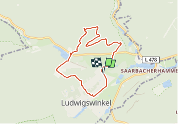
Tour Zu Fuß von 6,9 km verfügbar auf Rheinland-Pfalz, Südwestpfalz, Ludwigswinkel. Diese Tour wird von SityTrail - itinéraires balisés pédestres vorgeschlagen.
Beschreibung
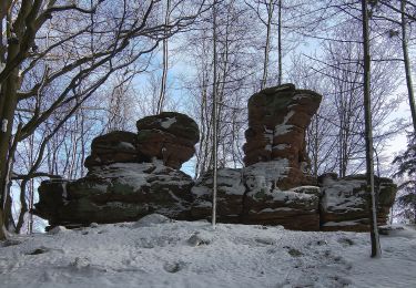
Symbol: Stilisierter Grüner Felsen mit grüner Leiter auf gelbem Grund mit grüner Unterschrift "Horbachkanzel-Runde"
Ort
Land:
Germany
Region :
Rheinland-Pfalz
Abteilung/Provinz :
Südwestpfalz
Kommune :
Ludwigswinkel
Standort:
Unknown
Gehen Sie:(Dec)
Gehen Sie:(UTM)
402829 ; 5437456 (32U) N.
Kommentare
Touren in der Umgebung
![Tour Zu Fuß Stürzelbronn - Bei den Möchen von Sturzelbronn - Photo](https://media.geolcdn.com/t/375/260/ext.jpg?maxdim=2&url=https%3A%2F%2Fmedia.geolcdn.com%2Ff%2Fcaf7594f-14b2-48e2-8398-22008e31622f.jpeg)
![Zu Fuß Zu Fuß](https://static1.geolcdn.com/sitytour/trail-icons/100.png)
Bei den Möchen von Sturzelbronn
Zu Fuß
Einfach
Stürzelbronn,
Großer Osten,
Mosel,
France
![](/images/other/stat-length.png)
10,9 km | 14,8 km-effort
3h 22min
![](https://static1.geolcdn.com/siteimages/upload/files/16400158638029165_repeat_loop_refresh_sync_direction_icon.png)
Ja
![Tour Zu Fuß Niedersteinbach - Anneau bleu - Photo](https://media.geolcdn.com/t/375/260/ext.jpg?maxdim=2&url=https%3A%2F%2Fmedia.geolcdn.com%2Ff%2F2ce4a169-1183-4834-953e-6328c36b8057.jpeg)
![Zu Fuß Zu Fuß](https://static1.geolcdn.com/sitytour/trail-icons/100.png)
Anneau bleu
Zu Fuß
Einfach
Niedersteinbach,
Großer Osten,
Unterelsass,
France
![](/images/other/stat-length.png)
3,9 km | 6,8 km-effort
1h 32min
![](https://static1.geolcdn.com/siteimages/upload/files/16400158638029165_repeat_loop_refresh_sync_direction_icon.png)
Ja
![Tour Zu Fuß Niedersteinbach - Anneau jaune - Photo](https://media.geolcdn.com/t/375/260/ext.jpg?maxdim=2&url=https%3A%2F%2Fmedia.geolcdn.com%2Ff%2F864ec68b-7e8c-46d6-8de7-bd04be428ab9.jpeg)
![Zu Fuß Zu Fuß](https://static1.geolcdn.com/sitytour/trail-icons/100.png)
Anneau jaune
Zu Fuß
Einfach
Niedersteinbach,
Großer Osten,
Unterelsass,
France
![](/images/other/stat-length.png)
3,4 km | 4,9 km-effort
1h 6min
![](https://static1.geolcdn.com/siteimages/upload/files/16400158638029165_repeat_loop_refresh_sync_direction_icon.png)
Ja
![Tour Zu Fuß Stürzelbronn - Entdeckungsroute Landschaft über Grenzen #3 - Photo](https://media.geolcdn.com/t/375/260/ext.jpg?maxdim=2&url=https%3A%2F%2Fmedia.geolcdn.com%2Ff%2F9a7ba633-a867-49a1-a146-4bd2e867222a.jpeg)
![Zu Fuß Zu Fuß](https://static1.geolcdn.com/sitytour/trail-icons/100.png)
Entdeckungsroute Landschaft über Grenzen #3
Zu Fuß
Einfach
Stürzelbronn,
Großer Osten,
Mosel,
France
![](/images/other/stat-length.png)
10 km | 13,8 km-effort
3h 8min
![](https://static1.geolcdn.com/siteimages/upload/files/16400158638029165_repeat_loop_refresh_sync_direction_icon.png)
Ja
![Tour Zu Fuß Schönau (Pfalz) - Triangle rouge - Photo](https://media.geolcdn.com/t/375/260/ext.jpg?maxdim=2&url=https%3A%2F%2Fmedia.geolcdn.com%2Ff%2Fc37e08a9-77fa-4c6c-8b97-059397a874b3.jpeg)
![Zu Fuß Zu Fuß](https://static1.geolcdn.com/sitytour/trail-icons/100.png)
Triangle rouge
Zu Fuß
Einfach
Schönau (Pfalz),
Rheinland-Pfalz,
Südwestpfalz,
Germany
![](/images/other/stat-length.png)
5,5 km | 8,2 km-effort
1h 51min
![](https://static1.geolcdn.com/siteimages/upload/files/16400158638029165_repeat_loop_refresh_sync_direction_icon.png)
Nein
![Tour Zu Fuß Niedersteinbach - Croix rouge - Photo](https://media.geolcdn.com/t/375/260/ext.jpg?maxdim=2&url=https%3A%2F%2Fmedia.geolcdn.com%2Ff%2F864ec68b-7e8c-46d6-8de7-bd04be428ab9.jpeg)
![Zu Fuß Zu Fuß](https://static1.geolcdn.com/sitytour/trail-icons/100.png)
Croix rouge
Zu Fuß
Einfach
Niedersteinbach,
Großer Osten,
Unterelsass,
France
![](/images/other/stat-length.png)
5,7 km | 9,5 km-effort
2h 9min
![](https://static1.geolcdn.com/siteimages/upload/files/16400158638029165_repeat_loop_refresh_sync_direction_icon.png)
Nein
![Tour Zu Fuß Ludwigswinkel - Hohe List-Tour - Photo](https://media.geolcdn.com/t/375/260/ext.jpg?maxdim=2&url=https%3A%2F%2Fmedia.geolcdn.com%2Ff%2F5498a04f-ba6b-4345-82fb-7bd25f635273.jpeg)
![Zu Fuß Zu Fuß](https://static1.geolcdn.com/sitytour/trail-icons/100.png)
Hohe List-Tour
Zu Fuß
Medium
Ludwigswinkel,
Rheinland-Pfalz,
Südwestpfalz,
Germany
![](/images/other/stat-length.png)
16,9 km | 23 km-effort
5h 10min
![](https://static1.geolcdn.com/siteimages/upload/files/16400158638029165_repeat_loop_refresh_sync_direction_icon.png)
Ja
![Tour Zu Fuß Ludwigswinkel - Lindelskopf-Tour - Photo](https://media.geolcdn.com/t/375/260/ext.jpg?maxdim=2&url=https%3A%2F%2Fmedia.geolcdn.com%2Ff%2F5498a04f-ba6b-4345-82fb-7bd25f635273.jpeg)
![Zu Fuß Zu Fuß](https://static1.geolcdn.com/sitytour/trail-icons/100.png)
Lindelskopf-Tour
Zu Fuß
Einfach
Ludwigswinkel,
Rheinland-Pfalz,
Südwestpfalz,
Germany
![](/images/other/stat-length.png)
7 km | 9,1 km-effort
2h 4min
![](https://static1.geolcdn.com/siteimages/upload/files/16400158638029165_repeat_loop_refresh_sync_direction_icon.png)
Ja
![Tour Zu Fuß Ludwigswinkel - Rumberg-Steig - Photo](https://media.geolcdn.com/t/375/260/ext.jpg?maxdim=2&url=https%3A%2F%2Fmedia.geolcdn.com%2Ff%2F5498a04f-ba6b-4345-82fb-7bd25f635273.jpeg)
![Zu Fuß Zu Fuß](https://static1.geolcdn.com/sitytour/trail-icons/100.png)
Rumberg-Steig
Zu Fuß
Einfach
Ludwigswinkel,
Rheinland-Pfalz,
Südwestpfalz,
Germany
![](/images/other/stat-length.png)
11,3 km | 15,2 km-effort
3h 27min
![](https://static1.geolcdn.com/siteimages/upload/files/16400158638029165_repeat_loop_refresh_sync_direction_icon.png)
Ja