![](/images/other/stat-length.png)
![Tour Zu Fuß Mayschoß - Mayschoß - Rundweg 3 - Photo](https://media.geolcdn.com/t/1900/400/16f600b5-0607-441e-b639-8cbd6e404fe6.jpeg&format=pjpeg&maxdim=2)
Mayschoß - Rundweg 3
SityTrail - itinéraires balisés pédestres
Tous les sentiers balisés d’Europe GUIDE+
![Länge](/images/other/stat-length.png)
Länge
7,2 km
![Maximale Höhe](https://static1.geolcdn.com/siteimages/upload/files/1508320355ic_sort_altitude_max_24dp.png)
Maximale Höhe
481 m
![Positive Höhendifferenz](https://static1.geolcdn.com/siteimages/upload/files/1508320355ic_sort_den_pos_24dp.png)
Positive Höhendifferenz
349 m
![Km-Effort](/images/other/stat-length.png)
Km-Effort
11,9 km
![Min. Höhe](https://static1.geolcdn.com/siteimages/upload/files/1508320355ic_sort_altitude_min_24dp.png)
Min. Höhe
138 m
![Negative Höhendifferenz](https://static1.geolcdn.com/siteimages/upload/files/1508320355ic_sort_den_neg_24dp.png)
Negative Höhendifferenz
349 m
![Boucle](https://static1.geolcdn.com/siteimages/upload/files/16400158638029165_repeat_loop_refresh_sync_direction_icon.png)
Boucle
Ja
Kennzeichnung
Erstellungsdatum :
2022-02-11 16:59:57.527
Letzte Änderung :
2022-02-11 16:59:57.527
![Zu Fuß](https://static1.geolcdn.com/sitytour/trail-icons/100.png)
2h41
Schwierigkeit : Einfach
![Scannen Sie diesen QR-Code, um die Tour in der SityTrail-Anwendung zu öffnen](https://capi.geolives.com/qq0zvz2zws4bq2lad0pu/sitytour/trails/3097149/qr.png?size=200)
Kostenlosegpshiking-Anwendung
Über SityTrail
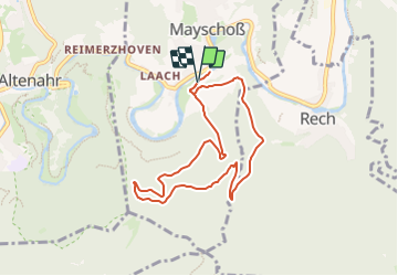
Tour Zu Fuß von 7,2 km verfügbar auf Rheinland-Pfalz, Landkreis Ahrweiler, Mayschoß. Diese Tour wird von SityTrail - itinéraires balisés pédestres vorgeschlagen.
Beschreibung
Trail created by Verkehrs- und Verschönerungsverein Mayschoß e.V..
Symbol: Weiße 3 in schwarzem Vollkreis auf weißem Hintergrund
Ort
Land:
Germany
Region :
Rheinland-Pfalz
Abteilung/Provinz :
Landkreis Ahrweiler
Kommune :
Mayschoß
Standort:
Unknown
Gehen Sie:(Dec)
Gehen Sie:(UTM)
359515 ; 5597947 (32U) N.
Kommentare
Touren in der Umgebung
![Tour Zu Fuß Mayschoß - Mayschoß - Rundweg 2 - Photo](https://media.geolcdn.com/t/375/260/16f600b5-0607-441e-b639-8cbd6e404fe6.jpeg&format=jpg&maxdim=2)
![Zu Fuß Zu Fuß](https://static1.geolcdn.com/sitytour/trail-icons/100.png)
Mayschoß - Rundweg 2
Zu Fuß
Einfach
Mayschoß,
Rheinland-Pfalz,
Landkreis Ahrweiler,
Germany
![](/images/other/stat-length.png)
5,8 km | 9,8 km-effort
2h 13min
![](https://static1.geolcdn.com/siteimages/upload/files/16400158638029165_repeat_loop_refresh_sync_direction_icon.png)
Ja
![Tour Zu Fuß Mayschoß - Mayschoß - Rundweg 1 - Photo](https://media.geolcdn.com/t/375/260/16f600b5-0607-441e-b639-8cbd6e404fe6.jpeg&format=jpg&maxdim=2)
![Zu Fuß Zu Fuß](https://static1.geolcdn.com/sitytour/trail-icons/100.png)
Mayschoß - Rundweg 1
Zu Fuß
Einfach
Mayschoß,
Rheinland-Pfalz,
Landkreis Ahrweiler,
Germany
![](/images/other/stat-length.png)
3,8 km | 6,2 km-effort
1h 24min
![](https://static1.geolcdn.com/siteimages/upload/files/16400158638029165_repeat_loop_refresh_sync_direction_icon.png)
Ja
![Tour Zu Fuß Altenahr - Gottfried-Kinkel-Weg - Photo](https://media.geolcdn.com/t/375/260/56366be1-f933-47d3-b229-3722b4a18fdb.jpeg&format=jpg&maxdim=2)
![Zu Fuß Zu Fuß](https://static1.geolcdn.com/sitytour/trail-icons/100.png)
Gottfried-Kinkel-Weg
Zu Fuß
Einfach
Altenahr,
Rheinland-Pfalz,
Landkreis Ahrweiler,
Germany
![](/images/other/stat-length.png)
9,7 km | 14,6 km-effort
3h 19min
![](https://static1.geolcdn.com/siteimages/upload/files/16400158638029165_repeat_loop_refresh_sync_direction_icon.png)
Nein
![Tour Zu Fuß Altenahr - Sahrbachweg - Photo](https://media.geolcdn.com/t/375/260/436e4f06-a858-4c94-b3a9-d0115085abf6.jpeg&format=jpg&maxdim=2)
![Zu Fuß Zu Fuß](https://static1.geolcdn.com/sitytour/trail-icons/100.png)
Sahrbachweg
Zu Fuß
Einfach
Altenahr,
Rheinland-Pfalz,
Landkreis Ahrweiler,
Germany
![](/images/other/stat-length.png)
8,2 km | 11,2 km-effort
2h 32min
![](https://static1.geolcdn.com/siteimages/upload/files/16400158638029165_repeat_loop_refresh_sync_direction_icon.png)
Nein
![Tour Zu Fuß Altenahr - Kotzberger Weg - Photo](https://media.geolcdn.com/t/375/260/fbc56b0b-96d8-4c9b-a866-87396f219721.jpeg&format=jpg&maxdim=2)
![Zu Fuß Zu Fuß](https://static1.geolcdn.com/sitytour/trail-icons/100.png)
Kotzberger Weg
Zu Fuß
Einfach
Altenahr,
Rheinland-Pfalz,
Landkreis Ahrweiler,
Germany
![](/images/other/stat-length.png)
3,2 km | 4,9 km-effort
1h 7min
![](https://static1.geolcdn.com/siteimages/upload/files/16400158638029165_repeat_loop_refresh_sync_direction_icon.png)
Nein
![Tour Zu Fuß Altenahr - Altenahr Rundweg 2 - Photo](https://media.geolcdn.com/t/375/260/9471d7e4-5f47-4647-8922-bdef73c6c06b.jpeg&format=jpg&maxdim=2)
![Zu Fuß Zu Fuß](https://static1.geolcdn.com/sitytour/trail-icons/100.png)
Altenahr Rundweg 2
Zu Fuß
Einfach
Altenahr,
Rheinland-Pfalz,
Landkreis Ahrweiler,
Germany
![](/images/other/stat-length.png)
3,2 km | 4,5 km-effort
1h 1min
![](https://static1.geolcdn.com/siteimages/upload/files/16400158638029165_repeat_loop_refresh_sync_direction_icon.png)
Ja
![Tour Zu Fuß Altenahr - Altenahr Rundweg 3 - Photo](https://media.geolcdn.com/t/375/260/7f317ab8-ece3-4330-9878-22a7250d772e.jpeg&format=jpg&maxdim=2)
![Zu Fuß Zu Fuß](https://static1.geolcdn.com/sitytour/trail-icons/100.png)
Altenahr Rundweg 3
Zu Fuß
Einfach
Altenahr,
Rheinland-Pfalz,
Landkreis Ahrweiler,
Germany
![](/images/other/stat-length.png)
4,6 km | 6,8 km-effort
1h 32min
![](https://static1.geolcdn.com/siteimages/upload/files/16400158638029165_repeat_loop_refresh_sync_direction_icon.png)
Ja
![Tour Zu Fuß Kesseling - [⑨] Rundweg Kesseling 9 - Photo](https://media.geolcdn.com/t/375/260/4dbbe2ae-b239-4136-9a63-e512e4629c8b.jpeg&format=jpg&maxdim=2)
![Zu Fuß Zu Fuß](https://static1.geolcdn.com/sitytour/trail-icons/100.png)
[⑨] Rundweg Kesseling 9
Zu Fuß
Einfach
Kesseling,
Rheinland-Pfalz,
Landkreis Ahrweiler,
Germany
![](/images/other/stat-length.png)
3,3 km | 5,3 km-effort
1h 11min
![](https://static1.geolcdn.com/siteimages/upload/files/16400158638029165_repeat_loop_refresh_sync_direction_icon.png)
Nein
![Tour Zu Fuß Kesseling - [②] Rundweg Kesseling 2 - Photo](https://media.geolcdn.com/t/375/260/e28c37ed-289e-49ae-9f9a-74ed114331b4.jpeg&format=jpg&maxdim=2)
![Zu Fuß Zu Fuß](https://static1.geolcdn.com/sitytour/trail-icons/100.png)
[②] Rundweg Kesseling 2
Zu Fuß
Einfach
Kesseling,
Rheinland-Pfalz,
Landkreis Ahrweiler,
Germany
![](/images/other/stat-length.png)
10,6 km | 15,4 km-effort
3h 29min
![](https://static1.geolcdn.com/siteimages/upload/files/16400158638029165_repeat_loop_refresh_sync_direction_icon.png)
Ja