![](/images/other/stat-length.png)
![Tour Zu Fuß Acht - Wanderather - Photo](https://media.geolcdn.com/t/1900/400/b277f1c9-e116-4561-a875-5a24a219b12f.jpeg&format=pjpeg&maxdim=2)
Wanderather
SityTrail - itinéraires balisés pédestres
Tous les sentiers balisés d’Europe GUIDE+
![Länge](/images/other/stat-length.png)
Länge
12,4 km
![Maximale Höhe](https://static1.geolcdn.com/siteimages/upload/files/1508320355ic_sort_altitude_max_24dp.png)
Maximale Höhe
548 m
![Positive Höhendifferenz](https://static1.geolcdn.com/siteimages/upload/files/1508320355ic_sort_den_pos_24dp.png)
Positive Höhendifferenz
351 m
![Km-Effort](/images/other/stat-length.png)
Km-Effort
17,1 km
![Min. Höhe](https://static1.geolcdn.com/siteimages/upload/files/1508320355ic_sort_altitude_min_24dp.png)
Min. Höhe
365 m
![Negative Höhendifferenz](https://static1.geolcdn.com/siteimages/upload/files/1508320355ic_sort_den_neg_24dp.png)
Negative Höhendifferenz
351 m
![Boucle](https://static1.geolcdn.com/siteimages/upload/files/16400158638029165_repeat_loop_refresh_sync_direction_icon.png)
Boucle
Nein
Kennzeichnung
Erstellungsdatum :
2022-02-11 16:08:41.778
Letzte Änderung :
2022-02-11 16:08:41.778
![Zu Fuß](https://static1.geolcdn.com/sitytour/trail-icons/100.png)
3h52
Schwierigkeit : Einfach
![Scannen Sie diesen QR-Code, um die Tour in der SityTrail-Anwendung zu öffnen](https://capi.geolives.com/qq0zvz2zws4bq2lad0pu/sitytour/trails/3095813/qr.png?size=200)
Kostenlosegpshiking-Anwendung
Über SityTrail
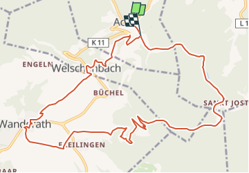
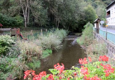
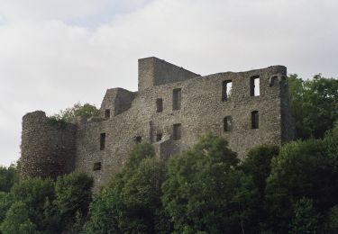
Tour Zu Fuß von 12,4 km verfügbar auf Rheinland-Pfalz, Landkreis Mayen-Koblenz, Acht. Diese Tour wird von SityTrail - itinéraires balisés pédestres vorgeschlagen.
Beschreibung
Trail created by Rhein-Mosel-Eifel-Touristik.
Symbol: Oranger Hintergrund mit weißem Weg - Traumpfade
Ort
Land:
Germany
Region :
Rheinland-Pfalz
Abteilung/Provinz :
Landkreis Mayen-Koblenz
Kommune :
Acht
Standort:
Unknown
Gehen Sie:(Dec)
Gehen Sie:(UTM)
363036 ; 5581495 (32U) N.
Kommentare
Touren in der Umgebung
![Tour Zu Fuß Lind - Booser Doppelmaartour - Photo](https://media.geolcdn.com/t/375/260/1e47e8c9-736a-45d8-91a0-fc62420c2953.jpeg&format=jpg&maxdim=2)
![Zu Fuß Zu Fuß](https://static1.geolcdn.com/sitytour/trail-icons/100.png)
Booser Doppelmaartour
Zu Fuß
Einfach
Lind,
Rheinland-Pfalz,
Landkreis Mayen-Koblenz,
Germany
![](/images/other/stat-length.png)
9,1 km | 11,7 km-effort
2h 38min
![](https://static1.geolcdn.com/siteimages/upload/files/16400158638029165_repeat_loop_refresh_sync_direction_icon.png)
Ja
![Tour Zu Fuß Langscheid - Wacholderweg - Photo](https://media.geolcdn.com/t/375/260/df2bc356-4117-4c05-9360-e9b6f3d66f76.jpeg&format=jpg&maxdim=2)
![Zu Fuß Zu Fuß](https://static1.geolcdn.com/sitytour/trail-icons/100.png)
Wacholderweg
Zu Fuß
Einfach
Langscheid,
Rheinland-Pfalz,
Landkreis Mayen-Koblenz,
Germany
![](/images/other/stat-length.png)
7,2 km | 10,2 km-effort
2h 19min
![](https://static1.geolcdn.com/siteimages/upload/files/16400158638029165_repeat_loop_refresh_sync_direction_icon.png)
Nein
![Tour Zu Fuß Mayen - DE-8 - Photo](https://media.geolcdn.com/t/375/260/8b43a2e6-3bc2-41b8-be4f-03d51604523a.jpeg&format=jpg&maxdim=2)
![Zu Fuß Zu Fuß](https://static1.geolcdn.com/sitytour/trail-icons/100.png)
DE-8
Zu Fuß
Einfach
Mayen,
Rheinland-Pfalz,
Landkreis Mayen-Koblenz,
Germany
![](/images/other/stat-length.png)
4,4 km | 5,9 km-effort
1h 21min
![](https://static1.geolcdn.com/siteimages/upload/files/16400158638029165_repeat_loop_refresh_sync_direction_icon.png)
Nein
![Tour Zu Fuß Virneburg - Virne-Burgweg - Photo](https://media.geolcdn.com/t/375/260/52cd3d8b-4f1b-4585-af5c-d7774d6fba90.jpeg&format=jpg&maxdim=2)
![Zu Fuß Zu Fuß](https://static1.geolcdn.com/sitytour/trail-icons/100.png)
Virne-Burgweg
Zu Fuß
Einfach
Virneburg,
Rheinland-Pfalz,
Landkreis Mayen-Koblenz,
Germany
![](/images/other/stat-length.png)
9,8 km | 13,7 km-effort
3h 6min
![](https://static1.geolcdn.com/siteimages/upload/files/16400158638029165_repeat_loop_refresh_sync_direction_icon.png)
Ja
![Tour Wandern Arft - Trumpfade Arft et sa rivière à descendre voir. - Photo](https://media.geolcdn.com/t/375/260/ext.jpg?maxdim=2&url=https%3A%2F%2Fstatic1.geolcdn.com%2Fsiteimages%2Fupload%2Ffiles%2F1553511878bg_sport_marche.png)
![Wandern Wandern](https://static1.geolcdn.com/sitytour/trail-icons/101.png)
Trumpfade Arft et sa rivière à descendre voir.
Wandern
Einfach
Arft,
Rheinland-Pfalz,
Landkreis Mayen-Koblenz,
Germany
![](/images/other/stat-length.png)
10,3 km | 14,3 km-effort
2h 48min
![](https://static1.geolcdn.com/siteimages/upload/files/16400158638029165_repeat_loop_refresh_sync_direction_icon.png)
Ja