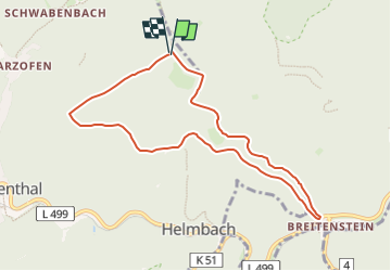
![](/images/other/stat-length.png)
![Tour Zu Fuß Elmstein - DE-4 - Photo](https://media.geolcdn.com/t/1900/400/ext.pjpeg?maxdim=2&url=https%3A%2F%2Fmedia.geolcdn.com%2Ff%2F07363d0a-aace-4ec4-8d24-f426ac52edc1.jpeg)
DE-4
SityTrail - itinéraires balisés pédestres
Tous les sentiers balisés d’Europe PRO
![Länge](/images/other/stat-length.png)
Länge
8 km
![Maximale Höhe](https://static1.geolcdn.com/siteimages/upload/files/1508320355ic_sort_altitude_max_24dp.png)
Maximale Höhe
418 m
![Positive Höhendifferenz](https://static1.geolcdn.com/siteimages/upload/files/1508320355ic_sort_den_pos_24dp.png)
Positive Höhendifferenz
231 m
![Km-Effort](/images/other/stat-length.png)
Km-Effort
11,1 km
![Min. Höhe](https://static1.geolcdn.com/siteimages/upload/files/1508320355ic_sort_altitude_min_24dp.png)
Min. Höhe
206 m
![Negative Höhendifferenz](https://static1.geolcdn.com/siteimages/upload/files/1508320355ic_sort_den_neg_24dp.png)
Negative Höhendifferenz
241 m
![Boucle](https://static1.geolcdn.com/siteimages/upload/files/16400158638029165_repeat_loop_refresh_sync_direction_icon.png)
Boucle
Ja
Kennzeichnung
Erstellungsdatum :
2022-02-11 15:36:48.583
Letzte Änderung :
2022-02-11 15:36:48.583
![Zu Fuß](https://static1.geolcdn.com/sitytour/trail-icons/100.png)
2h31
Schwierigkeit : Einfach
![Scannen Sie diesen QR-Code, um die Tour in der SityTrail-Anwendung zu öffnen](https://capi.geolives.com/qq0zvz2zws4bq2lad0pu/sitytour/trails/3094877/qr.png?size=200)
Kostenlosegpshiking-Anwendung
Über SityTrail
Tour Zu Fuß von 8 km verfügbar auf Rheinland-Pfalz, Landkreis Bad Dürkheim, Elmstein. Diese Tour wird von SityTrail - itinéraires balisés pédestres vorgeschlagen.
Beschreibung
Trail created by Pfälzerwald-Verein Esthal.
Symbol: black::white_dot:4:black
Ort
Land:
Germany
Region :
Rheinland-Pfalz
Abteilung/Provinz :
Landkreis Bad Dürkheim
Kommune :
Elmstein
Standort:
Unknown
Gehen Sie:(Dec)
Gehen Sie:(UTM)
425713 ; 5468191 (32U) N.
Kommentare
Touren in der Umgebung
![Tour Zu Fuß Elmstein - Rundwanderweg Iggelbach 5 - Photo](https://media.geolcdn.com/t/375/260/ext.jpg?maxdim=2&url=https%3A%2F%2Fmedia.geolcdn.com%2Ff%2F1fde10f1-c445-4c37-949a-61388fe88134.jpeg)
![Zu Fuß Zu Fuß](https://static1.geolcdn.com/sitytour/trail-icons/100.png)
Rundwanderweg Iggelbach 5
Zu Fuß
Einfach
Elmstein,
Rheinland-Pfalz,
Landkreis Bad Dürkheim,
Germany
![](/images/other/stat-length.png)
6 km | 9 km-effort
2h 2min
![](https://static1.geolcdn.com/siteimages/upload/files/16400158638029165_repeat_loop_refresh_sync_direction_icon.png)
Nein
![Tour Zu Fuß Elmstein - Elmstein Rundwanderweg 2 - Photo](https://media.geolcdn.com/t/375/260/ext.jpg?maxdim=2&url=https%3A%2F%2Fmedia.geolcdn.com%2Ff%2F0402e13a-a222-4bda-b77b-cb944b2ba216.jpeg)
![Zu Fuß Zu Fuß](https://static1.geolcdn.com/sitytour/trail-icons/100.png)
Elmstein Rundwanderweg 2
Zu Fuß
Einfach
Elmstein,
Rheinland-Pfalz,
Landkreis Bad Dürkheim,
Germany
![](/images/other/stat-length.png)
4,6 km | 7,4 km-effort
1h 40min
![](https://static1.geolcdn.com/siteimages/upload/files/16400158638029165_repeat_loop_refresh_sync_direction_icon.png)
Ja
![Tour Zu Fuß Elmstein - Elmstein Rundwanderweg 1 - Photo](https://media.geolcdn.com/t/375/260/ext.jpg?maxdim=2&url=https%3A%2F%2Fmedia.geolcdn.com%2Ff%2F3b3fb7e5-c6cb-40a3-aa65-cac8c892092f.jpeg)
![Zu Fuß Zu Fuß](https://static1.geolcdn.com/sitytour/trail-icons/100.png)
Elmstein Rundwanderweg 1
Zu Fuß
Einfach
Elmstein,
Rheinland-Pfalz,
Landkreis Bad Dürkheim,
Germany
![](/images/other/stat-length.png)
5,1 km | 7,7 km-effort
1h 45min
![](https://static1.geolcdn.com/siteimages/upload/files/16400158638029165_repeat_loop_refresh_sync_direction_icon.png)
Nein
![Tour Zu Fuß Esthal - DE-2 Breitenstein - Photo](https://media.geolcdn.com/t/375/260/ext.jpg?maxdim=2&url=https%3A%2F%2Fmedia.geolcdn.com%2Ff%2Ff9fa4a96-04fe-44f1-a47d-dec0e47ed68a.jpeg)
![Zu Fuß Zu Fuß](https://static1.geolcdn.com/sitytour/trail-icons/100.png)
DE-2 Breitenstein
Zu Fuß
Einfach
Esthal,
Rheinland-Pfalz,
Landkreis Bad Dürkheim,
Germany
![](/images/other/stat-length.png)
6 km | 8,9 km-effort
2h 1min
![](https://static1.geolcdn.com/siteimages/upload/files/16400158638029165_repeat_loop_refresh_sync_direction_icon.png)
Ja
![Tour Zu Fuß Esthal - DE-3 - Photo](https://media.geolcdn.com/t/375/260/ext.jpg?maxdim=2&url=https%3A%2F%2Fmedia.geolcdn.com%2Ff%2F07363d0a-aace-4ec4-8d24-f426ac52edc1.jpeg)
![Zu Fuß Zu Fuß](https://static1.geolcdn.com/sitytour/trail-icons/100.png)
DE-3
Zu Fuß
Einfach
Esthal,
Rheinland-Pfalz,
Landkreis Bad Dürkheim,
Germany
![](/images/other/stat-length.png)
7,8 km | 10,8 km-effort
2h 27min
![](https://static1.geolcdn.com/siteimages/upload/files/16400158638029165_repeat_loop_refresh_sync_direction_icon.png)
Ja
![Tour Zu Fuß Unbekannt - Rundwanderweg 3, Parkplatz Spangenberg - Photo](https://media.geolcdn.com/t/375/260/ext.jpg?maxdim=2&url=https%3A%2F%2Fmedia.geolcdn.com%2Ff%2Ff9fa4a96-04fe-44f1-a47d-dec0e47ed68a.jpeg)
![Zu Fuß Zu Fuß](https://static1.geolcdn.com/sitytour/trail-icons/100.png)
Rundwanderweg 3, Parkplatz Spangenberg
Zu Fuß
Einfach
Unbekannt,
Rheinland-Pfalz,
Neustadt an der Weinstraße,
Germany
![](/images/other/stat-length.png)
5,1 km | 8,2 km-effort
1h 51min
![](https://static1.geolcdn.com/siteimages/upload/files/16400158638029165_repeat_loop_refresh_sync_direction_icon.png)
Ja
![Tour Zu Fuß Unbekannt - Rundwanderweg 2, Parkplatz Spangenberg - Photo](https://media.geolcdn.com/t/375/260/ext.jpg?maxdim=2&url=https%3A%2F%2Fmedia.geolcdn.com%2Ff%2Ff9fa4a96-04fe-44f1-a47d-dec0e47ed68a.jpeg)
![Zu Fuß Zu Fuß](https://static1.geolcdn.com/sitytour/trail-icons/100.png)
Rundwanderweg 2, Parkplatz Spangenberg
Zu Fuß
Einfach
Unbekannt,
Rheinland-Pfalz,
Neustadt an der Weinstraße,
Germany
![](/images/other/stat-length.png)
10 km | 14,3 km-effort
3h 14min
![](https://static1.geolcdn.com/siteimages/upload/files/16400158638029165_repeat_loop_refresh_sync_direction_icon.png)
Ja
![Tour Zu Fuß Elmstein - Rundweg um Elmstein 8 - Photo](https://media.geolcdn.com/t/375/260/ext.jpg?maxdim=2&url=https%3A%2F%2Fmedia.geolcdn.com%2Ff%2F3b3fb7e5-c6cb-40a3-aa65-cac8c892092f.jpeg)
![Zu Fuß Zu Fuß](https://static1.geolcdn.com/sitytour/trail-icons/100.png)
Rundweg um Elmstein 8
Zu Fuß
Einfach
Elmstein,
Rheinland-Pfalz,
Landkreis Bad Dürkheim,
Germany
![](/images/other/stat-length.png)
10,5 km | 15,5 km-effort
3h 31min
![](https://static1.geolcdn.com/siteimages/upload/files/16400158638029165_repeat_loop_refresh_sync_direction_icon.png)
Ja
![Tour Zu Fuß Esthal - Drei-Burgen-Rundweg, Lambrecht, Pfalz - Photo](https://media.geolcdn.com/t/375/260/ext.jpg?maxdim=2&url=https%3A%2F%2Fmedia.geolcdn.com%2Ff%2Ff9fa4a96-04fe-44f1-a47d-dec0e47ed68a.jpeg)
![Zu Fuß Zu Fuß](https://static1.geolcdn.com/sitytour/trail-icons/100.png)
Drei-Burgen-Rundweg, Lambrecht, Pfalz
Zu Fuß
Einfach
Esthal,
Rheinland-Pfalz,
Landkreis Bad Dürkheim,
Germany
![](/images/other/stat-length.png)
4,4 km | 6,5 km-effort
1h 28min
![](https://static1.geolcdn.com/siteimages/upload/files/16400158638029165_repeat_loop_refresh_sync_direction_icon.png)
Ja