![](/images/other/stat-length.png)
![Tour Zu Fuß Unknown - Kulturweg Aschaffenburg 7 - Photo](https://media.geolcdn.com/t/1900/400/ext.pjpeg?maxdim=2&url=https%3A%2F%2Fmedia.geolcdn.com%2Ff%2Ffccbda03-0511-48a4-a333-5f665996420e.jpeg)
Kulturweg Aschaffenburg 7
SityTrail - itinéraires balisés pédestres
Tous les sentiers balisés d’Europe PRO
![Länge](/images/other/stat-length.png)
Länge
7,4 km
![Maximale Höhe](https://static1.geolcdn.com/siteimages/upload/files/1508320355ic_sort_altitude_max_24dp.png)
Maximale Höhe
145 m
![Positive Höhendifferenz](https://static1.geolcdn.com/siteimages/upload/files/1508320355ic_sort_den_pos_24dp.png)
Positive Höhendifferenz
53 m
![Km-Effort](/images/other/stat-length.png)
Km-Effort
8,2 km
![Min. Höhe](https://static1.geolcdn.com/siteimages/upload/files/1508320355ic_sort_altitude_min_24dp.png)
Min. Höhe
114 m
![Negative Höhendifferenz](https://static1.geolcdn.com/siteimages/upload/files/1508320355ic_sort_den_neg_24dp.png)
Negative Höhendifferenz
58 m
![Boucle](https://static1.geolcdn.com/siteimages/upload/files/16400158638029165_repeat_loop_refresh_sync_direction_icon.png)
Boucle
Ja
Kennzeichnung
Erstellungsdatum :
2022-02-11 15:35:54.242
Letzte Änderung :
2022-02-11 15:35:54.242
![Zu Fuß](https://static1.geolcdn.com/sitytour/trail-icons/100.png)
1h51
Schwierigkeit : Einfach
![Scannen Sie diesen QR-Code, um die Tour in der SityTrail-Anwendung zu öffnen](https://capi.geolives.com/qq0zvz2zws4bq2lad0pu/sitytour/trails/3094841/qr.png?size=200)
Kostenlosegpshiking-Anwendung
Über SityTrail
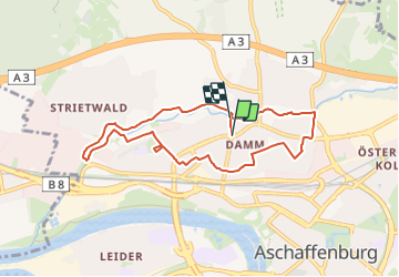
Tour Zu Fuß von 7,4 km verfügbar auf Bayern, Aschaffenburg. Diese Tour wird von SityTrail - itinéraires balisés pédestres vorgeschlagen.
Beschreibung
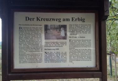
Trail created by Archäologisches Spessartprojekt.
Symbol: Gelbes EU-Schiffchen auf blauem Grund
Website: https://www.spessartprojekt.de/?page_id=10344
Ort
Land:
Germany
Region :
Bayern
Abteilung/Provinz :
Aschaffenburg
Kommune :
Unknown
Standort:
Unknown
Gehen Sie:(Dec)
Gehen Sie:(UTM)
509768 ; 5537038 (32U) N.
Kommentare
Touren in der Umgebung
![Tour Zu Fuß Haibach - Waldlehrpfad Haibach - Photo](https://media.geolcdn.com/t/375/260/ext.jpg?maxdim=2&url=https%3A%2F%2Fmedia.geolcdn.com%2Ff%2F62a06696-8444-4a85-86e3-d7f0481a7431.jpeg)
![Zu Fuß Zu Fuß](https://static1.geolcdn.com/sitytour/trail-icons/100.png)
Waldlehrpfad Haibach
Zu Fuß
Einfach
Haibach,
Bayern,
Landkreis Aschaffenburg,
Germany
![](/images/other/stat-length.png)
3,1 km | 4,1 km-effort
55min
![](https://static1.geolcdn.com/siteimages/upload/files/16400158638029165_repeat_loop_refresh_sync_direction_icon.png)
Ja
![Tour Zu Fuß Johannesberg - Roter Hase Rundwanderweg Johannesberg - Photo](https://media.geolcdn.com/t/375/260/ext.jpg?maxdim=2&url=https%3A%2F%2Fmedia.geolcdn.com%2Ff%2Fcc3587dc-8766-4d75-a554-77ecd178dfac.jpeg)
![Zu Fuß Zu Fuß](https://static1.geolcdn.com/sitytour/trail-icons/100.png)
Roter Hase Rundwanderweg Johannesberg
Zu Fuß
Einfach
Johannesberg,
Bayern,
Landkreis Aschaffenburg,
Germany
![](/images/other/stat-length.png)
7 km | 10 km-effort
2h 15min
![](https://static1.geolcdn.com/siteimages/upload/files/16400158638029165_repeat_loop_refresh_sync_direction_icon.png)
Ja
![Tour Zu Fuß Johannesberg - Ortswanderweg Johannesberg 1 - Photo](https://media.geolcdn.com/t/375/260/ext.jpg?maxdim=2&url=https%3A%2F%2Fmedia.geolcdn.com%2Ff%2F45f74531-bc9e-4201-afd7-a233b903d546.jpeg)
![Zu Fuß Zu Fuß](https://static1.geolcdn.com/sitytour/trail-icons/100.png)
Ortswanderweg Johannesberg 1
Zu Fuß
Einfach
Johannesberg,
Bayern,
Landkreis Aschaffenburg,
Germany
![](/images/other/stat-length.png)
3,6 km | 5,2 km-effort
1h 11min
![](https://static1.geolcdn.com/siteimages/upload/files/16400158638029165_repeat_loop_refresh_sync_direction_icon.png)
Nein
![Tour Zu Fuß Kleinostheim - Kulturweg Kleinostheim - Photo](https://media.geolcdn.com/t/375/260/ext.jpg?maxdim=2&url=https%3A%2F%2Fmedia.geolcdn.com%2Ff%2Fe88bec4e-92ba-489b-a2a6-fe5520b2694b.jpeg)
![Zu Fuß Zu Fuß](https://static1.geolcdn.com/sitytour/trail-icons/100.png)
Kulturweg Kleinostheim
Zu Fuß
Einfach
Kleinostheim,
Bayern,
Landkreis Aschaffenburg,
Germany
![](/images/other/stat-length.png)
9,7 km | 12,9 km-effort
2h 55min
![](https://static1.geolcdn.com/siteimages/upload/files/16400158638029165_repeat_loop_refresh_sync_direction_icon.png)
Nein
![Tour Zu Fuß Kleinostheim - Nordic Walking 2 Rot Kleinostheim - Photo](https://media.geolcdn.com/t/375/260/ext.jpg?maxdim=2&url=https%3A%2F%2Fmedia.geolcdn.com%2Ff%2F9f50d534-1efc-4413-bc8a-6894ebd41db5.jpeg)
![Zu Fuß Zu Fuß](https://static1.geolcdn.com/sitytour/trail-icons/100.png)
Nordic Walking 2 Rot Kleinostheim
Zu Fuß
Einfach
Kleinostheim,
Bayern,
Landkreis Aschaffenburg,
Germany
![](/images/other/stat-length.png)
6 km | 8,6 km-effort
1h 57min
![](https://static1.geolcdn.com/siteimages/upload/files/16400158638029165_repeat_loop_refresh_sync_direction_icon.png)
Ja
![Tour Zu Fuß Kleinostheim - Kulturweg Kleinostheim - Wanderung - Photo](https://media.geolcdn.com/t/375/260/ext.jpg?maxdim=2&url=https%3A%2F%2Fmedia.geolcdn.com%2Ff%2Fe88bec4e-92ba-489b-a2a6-fe5520b2694b.jpeg)
![Zu Fuß Zu Fuß](https://static1.geolcdn.com/sitytour/trail-icons/100.png)
Kulturweg Kleinostheim - Wanderung
Zu Fuß
Einfach
Kleinostheim,
Bayern,
Landkreis Aschaffenburg,
Germany
![](/images/other/stat-length.png)
9,7 km | 12,9 km-effort
2h 55min
![](https://static1.geolcdn.com/siteimages/upload/files/16400158638029165_repeat_loop_refresh_sync_direction_icon.png)
Nein
![Tour Zu Fuß - Nordic Walking 2 Rot Strietwald - Photo](https://media.geolcdn.com/t/375/260/ext.jpg?maxdim=2&url=https%3A%2F%2Fmedia.geolcdn.com%2Ff%2F76172452-1405-407d-a031-22861bd01d11.jpeg)
![Zu Fuß Zu Fuß](https://static1.geolcdn.com/sitytour/trail-icons/100.png)
Nordic Walking 2 Rot Strietwald
Zu Fuß
Einfach
,
Bayern,
Aschaffenburg,
Germany
![](/images/other/stat-length.png)
7,6 km | 10,1 km-effort
2h 17min
![](https://static1.geolcdn.com/siteimages/upload/files/16400158638029165_repeat_loop_refresh_sync_direction_icon.png)
Nein
![Tour Zu Fuß - Nordic Walking 3 Schwarz Strietwald - Photo](https://media.geolcdn.com/t/375/260/ext.jpg?maxdim=2&url=https%3A%2F%2Fmedia.geolcdn.com%2Ff%2F76172452-1405-407d-a031-22861bd01d11.jpeg)
![Zu Fuß Zu Fuß](https://static1.geolcdn.com/sitytour/trail-icons/100.png)
Nordic Walking 3 Schwarz Strietwald
Zu Fuß
Einfach
,
Bayern,
Aschaffenburg,
Germany
![](/images/other/stat-length.png)
7,8 km | 10,5 km-effort
2h 22min
![](https://static1.geolcdn.com/siteimages/upload/files/16400158638029165_repeat_loop_refresh_sync_direction_icon.png)
Nein
![Tour Zu Fuß - Roter Schmetterling, Rundwanderweg Schweinheim Erbig - Photo](https://media.geolcdn.com/t/375/260/ext.jpg?maxdim=2&url=https%3A%2F%2Fmedia.geolcdn.com%2Ff%2Fa9806206-d614-4dd0-9141-a8cd5b92414c.jpeg)
![Zu Fuß Zu Fuß](https://static1.geolcdn.com/sitytour/trail-icons/100.png)
Roter Schmetterling, Rundwanderweg Schweinheim Erbig
Zu Fuß
Einfach
,
Bayern,
Aschaffenburg,
Germany
![](/images/other/stat-length.png)
4 km | 5,3 km-effort
1h 12min
![](https://static1.geolcdn.com/siteimages/upload/files/16400158638029165_repeat_loop_refresh_sync_direction_icon.png)
Ja