![](/images/other/stat-length.png)
![Tour Zu Fuß Berching - Berching - Holnstein - Photo](https://media.geolcdn.com/t/1900/400/70bc2a95-37ba-468c-83c7-8ce50370f65b.jpeg&format=pjpeg&maxdim=2)
Berching - Holnstein
SityTrail - itinéraires balisés pédestres
Tous les sentiers balisés d’Europe GUIDE+
![Länge](/images/other/stat-length.png)
Länge
3,7 km
![Maximale Höhe](https://static1.geolcdn.com/siteimages/upload/files/1508320355ic_sort_altitude_max_24dp.png)
Maximale Höhe
526 m
![Positive Höhendifferenz](https://static1.geolcdn.com/siteimages/upload/files/1508320355ic_sort_den_pos_24dp.png)
Positive Höhendifferenz
18 m
![Km-Effort](/images/other/stat-length.png)
Km-Effort
4,3 km
![Min. Höhe](https://static1.geolcdn.com/siteimages/upload/files/1508320355ic_sort_altitude_min_24dp.png)
Min. Höhe
419 m
![Negative Höhendifferenz](https://static1.geolcdn.com/siteimages/upload/files/1508320355ic_sort_den_neg_24dp.png)
Negative Höhendifferenz
119 m
![Boucle](https://static1.geolcdn.com/siteimages/upload/files/16400158638029165_repeat_loop_refresh_sync_direction_icon.png)
Boucle
Nein
Kennzeichnung
Erstellungsdatum :
2022-02-11 15:34:22.13
Letzte Änderung :
2022-02-11 15:34:22.13
![Zu Fuß](https://static1.geolcdn.com/sitytour/trail-icons/100.png)
58m
Schwierigkeit : Einfach
![Scannen Sie diesen QR-Code, um die Tour in der SityTrail-Anwendung zu öffnen](https://capi.geolives.com/qq0zvz2zws4bq2lad0pu/sitytour/trails/3094787/qr.png?size=200)
Kostenlosegpshiking-Anwendung
Über SityTrail
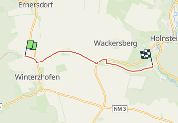
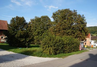
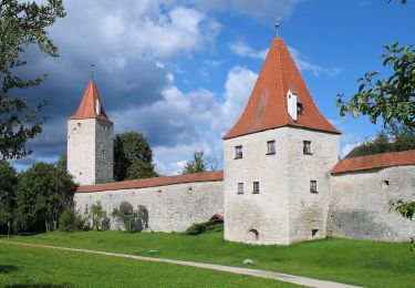
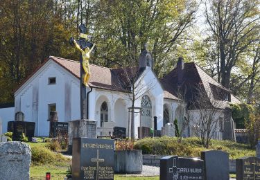
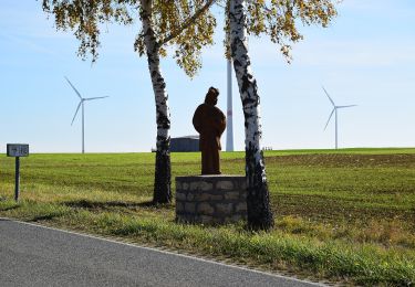
Tour Zu Fuß von 3,7 km verfügbar auf Bayern, Landkreis Neumarkt in der Oberpfalz, Berching. Diese Tour wird von SityTrail - itinéraires balisés pédestres vorgeschlagen.
Beschreibung
Trail created by Stadt Berching.
Symbol: Schwarze W1b auf gelbem Grund
Ort
Land:
Germany
Region :
Bayern
Abteilung/Provinz :
Landkreis Neumarkt in der Oberpfalz
Kommune :
Berching
Standort:
Unknown
Gehen Sie:(Dec)
Gehen Sie:(UTM)
679870 ; 5442652 (32U) N.
Kommentare
Touren in der Umgebung
![Tour Zu Fuß Berching - Wasser- und Mühlenweg - Photo](https://media.geolcdn.com/t/375/260/0f30577b-cb8c-433c-9898-83c9e06a4cab.jpeg&format=jpg&maxdim=2)
![Zu Fuß Zu Fuß](https://static1.geolcdn.com/sitytour/trail-icons/100.png)
Wasser- und Mühlenweg
Zu Fuß
Schwierig
Berching,
Bayern,
Landkreis Neumarkt in der Oberpfalz,
Germany
![](/images/other/stat-length.png)
22 km | 31 km-effort
7h 4min
![](https://static1.geolcdn.com/siteimages/upload/files/16400158638029165_repeat_loop_refresh_sync_direction_icon.png)
Nein
![Tour Zu Fuß Berching - Plankstetten - Oening - Photo](https://media.geolcdn.com/t/375/260/24a9071a-4aed-476c-b913-466963111fef.jpeg&format=jpg&maxdim=2)
![Zu Fuß Zu Fuß](https://static1.geolcdn.com/sitytour/trail-icons/100.png)
Plankstetten - Oening
Zu Fuß
Einfach
Berching,
Bayern,
Landkreis Neumarkt in der Oberpfalz,
Germany
![](/images/other/stat-length.png)
5,9 km | 7,4 km-effort
1h 41min
![](https://static1.geolcdn.com/siteimages/upload/files/16400158638029165_repeat_loop_refresh_sync_direction_icon.png)
Nein
![Tour Zu Fuß Berching - Benediktusweg - Photo](https://media.geolcdn.com/t/375/260/69d8dc5c-1e6d-4328-8342-6c70a13e7a2c.jpeg&format=jpg&maxdim=2)
![Zu Fuß Zu Fuß](https://static1.geolcdn.com/sitytour/trail-icons/100.png)
Benediktusweg
Zu Fuß
Einfach
Berching,
Bayern,
Landkreis Neumarkt in der Oberpfalz,
Germany
![](/images/other/stat-length.png)
12,6 km | 18,5 km-effort
4h 11min
![](https://static1.geolcdn.com/siteimages/upload/files/16400158638029165_repeat_loop_refresh_sync_direction_icon.png)
Ja
![Tour Zu Fuß Berching - Hoher Brunnen - Photo](https://media.geolcdn.com/t/375/260/55fecf17-a42a-4166-ac2b-1ad3b1fa7b1e.jpeg&format=jpg&maxdim=2)
![Zu Fuß Zu Fuß](https://static1.geolcdn.com/sitytour/trail-icons/100.png)
Hoher Brunnen
Zu Fuß
Einfach
Berching,
Bayern,
Landkreis Neumarkt in der Oberpfalz,
Germany
![](/images/other/stat-length.png)
10,1 km | 12,9 km-effort
2h 56min
![](https://static1.geolcdn.com/siteimages/upload/files/16400158638029165_repeat_loop_refresh_sync_direction_icon.png)
Ja
![Tour Zu Fuß Berching - Steinweg - Photo](https://media.geolcdn.com/t/375/260/718be3e5-e71f-4466-9c76-1b30cd02520a.jpeg&format=jpg&maxdim=2)
![Zu Fuß Zu Fuß](https://static1.geolcdn.com/sitytour/trail-icons/100.png)
Steinweg
Zu Fuß
Einfach
Berching,
Bayern,
Landkreis Neumarkt in der Oberpfalz,
Germany
![](/images/other/stat-length.png)
7,5 km | 10,1 km-effort
2h 17min
![](https://static1.geolcdn.com/siteimages/upload/files/16400158638029165_repeat_loop_refresh_sync_direction_icon.png)
Ja
![Tour Zu Fuß Berching - Jurasteig König-Ludwig-Schlaufe - Photo](https://media.geolcdn.com/t/375/260/70bc2a95-37ba-468c-83c7-8ce50370f65b.jpeg&format=jpg&maxdim=2)
![Zu Fuß Zu Fuß](https://static1.geolcdn.com/sitytour/trail-icons/100.png)
Jurasteig König-Ludwig-Schlaufe
Zu Fuß
Medium
Berching,
Bayern,
Landkreis Neumarkt in der Oberpfalz,
Germany
![](/images/other/stat-length.png)
15,9 km | 21 km-effort
4h 40min
![](https://static1.geolcdn.com/siteimages/upload/files/16400158638029165_repeat_loop_refresh_sync_direction_icon.png)
Nein