Tour Zu Fuß Allersberg - Die Rothsee-Tour - Photo

Tous les sentiers balisés d’Europe PRO

© OpenStreetMap contributors
Länge
Länge
23 km
Maximale Höhe
Maximale Höhe
415 m
Positive Höhendifferenz
286 m
Km-Effort
Km-Effort  
27 km
Min. Höhe
Min. Höhe
364 m
Negative Höhendifferenz
284 m
Boucle
Boucle
Ja
Kennzeichnung
Kennzeichnung
Erstellungsdatum :
2022-02-11 15:33:23.2
Letzte Änderung :
2022-02-11 15:33:23.2

(0 Nachricht)

Zu Fuß
Zu Fuß
6h09
Schwierigkeit : Medium

Scannen Sie diesen QR-Code, um die Tour in der SityTrail-Anwendung zu öffnen

Kostenlosegpshiking-Anwendung

Logo SityTrail SityTrail

IGN / Geografische Institute

SityTrail aus dem App Store herunterladen SityTrail von Google Play herunterladen

Logo SityTrail SityTrail World

Die Welt öffnet sich für Sie

SityTrail aus dem App Store herunterladen SityTrail von Google Play herunterladen SityTrail auf Huawei AppGallery herunterladen

Über SityTrail

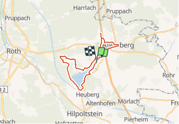
Tour Zu Fuß von 23 km verfügbar auf Bayern, Landkreis Roth, Allersberg. Diese Tour wird von SityTrail - itinéraires balisés pédestres vorgeschlagen.

Beschreibung

Übernommen aus einer GPX-Vorlage des Landkreises, mit Genehmigung des Amtes für Kultur und Tourismus (siehe http://wiki.openstreetmap.org/wiki/Landkreis_Roth#Lokale_Wanderwege)

Foto-Galerie

Ort

Land:
Germany
Region :
Bayern
Abteilung/Provinz :
Landkreis Roth
Kommune :
Allersberg
Standort:
Unknown
Gehen Sie:(UTM)
660563 ; 5455917 (32U) N.

Touren in der Umgebung

Tour Zu Fuß Hilpoltstein - Rothsee Rundweg No.11 - Photo
Zu Fuß
PRO

Zu Fuß

Einfach
Hilpoltstein, Bayern, Landkreis Roth, Germany
14 km | 16,5 km-effort
3h 44min
Nein
Tour Zu Fuß Hilpoltstein - Rothsee Rundweg No.8 - Photo
Zu Fuß
PRO

Zu Fuß

Einfach
Hilpoltstein, Bayern, Landkreis Roth, Germany
9 km | 10,6 km-effort
2h 24min
Nein
Tour Zu Fuß Allersberg - Quellen am Rothsee - Photo
Zu Fuß
PRO

Zu Fuß

Einfach
Allersberg, Bayern, Landkreis Roth, Germany
6,1 km | 7,3 km-effort
1h 39min
Ja
Tour Zu Fuß Roth - Rothsee Rundweg No.6 - Photo
Zu Fuß
PRO

Zu Fuß

Einfach
Roth, Bayern, Landkreis Roth, Germany
7,9 km | 8,9 km-effort
2h 1min
Nein
Tour Zu Fuß Roth - Rothsee Rundweg No.2 - Photo
Zu Fuß
PRO

Zu Fuß

Einfach
Roth, Bayern, Landkreis Roth, Germany
6,7 km | 7,7 km-effort
1h 44min
Ja
Tour Zu Fuß Hilpoltstein - Mühlenweg (Roth) - Photo
Zu Fuß
PRO

Zu Fuß

Einfach
Hilpoltstein, Bayern, Landkreis Roth, Germany
7,1 km | 8,2 km-effort
1h 51min
Nein
Tour Zu Fuß Hilpoltstein - Rothsee Rundweg No.10 - Photo
Zu Fuß
PRO

Zu Fuß

Einfach
Hilpoltstein, Bayern, Landkreis Roth, Germany
3 km | 3,4 km-effort
46min
Nein
Tour Zu Fuß Roth - Rothsee Rundweg No.9 - Photo
Zu Fuß
PRO

Zu Fuß

Einfach
Roth, Bayern, Landkreis Roth, Germany
14,2 km | 16,5 km-effort
3h 44min
Nein
Tour Zu Fuß Roth - Seebühler Rundweg - Photo
Zu Fuß
PRO

Zu Fuß

Einfach
Roth, Bayern, Landkreis Roth, Germany
9 km | 10,5 km-effort
2h 22min
Ja


Schließen
Meine Abonnements