


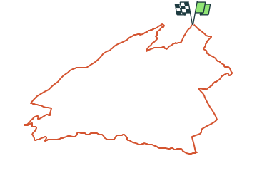

4,2 km | 6 km-effort

Tous les sentiers balisés d’Europe GUIDE+


Kostenlosegpshiking-Anwendung
 SityTrail
IGN / Geografische Institute
SityTrail World
Die Welt öffnet sich für Sie
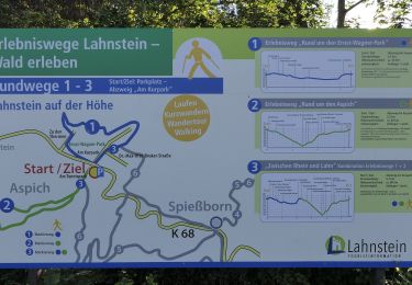
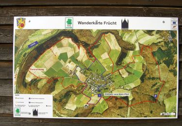
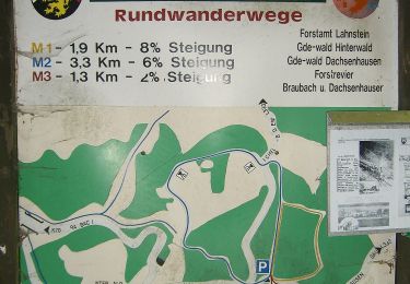
Tour Zu Fuß von 12,6 km verfügbar auf Rheinland-Pfalz, Landkreis Mayen-Koblenz, Brey. Diese Tour wird von SityTrail - itinéraires balisés pédestres vorgeschlagen.
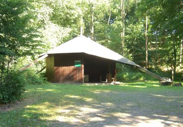
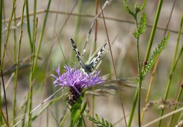
Ein Netz von Traumpfaden und Traumpfädchen durchzieht die Region und lädt Sie ein, die herrliche Landschaft mit ihren reichen Naturdenkmälern und kulturellen
Website: https://www.traumpfade.info/
 "
data-pinterest-text="Pin it"
data-tweet-text="share on twitter"
data-facebook-share-url="https://www.sitytrail.com/de/trails/3094425-brey--traumpfade-xrheingoldbogenx/?photo=1#lg=1&slide=1"
data-twitter-share-url="https://www.sitytrail.com/de/trails/3094425-brey--traumpfade-xrheingoldbogenx/?photo=1#lg=1&slide=1"
data-googleplus-share-url="https://www.sitytrail.com/de/trails/3094425-brey--traumpfade-xrheingoldbogenx/?photo=1#lg=1&slide=1"
data-pinterest-share-url="https://www.sitytrail.com/de/trails/3094425-brey--traumpfade-xrheingoldbogenx/?photo=1#lg=1&slide=1">
"
data-pinterest-text="Pin it"
data-tweet-text="share on twitter"
data-facebook-share-url="https://www.sitytrail.com/de/trails/3094425-brey--traumpfade-xrheingoldbogenx/?photo=1#lg=1&slide=1"
data-twitter-share-url="https://www.sitytrail.com/de/trails/3094425-brey--traumpfade-xrheingoldbogenx/?photo=1#lg=1&slide=1"
data-googleplus-share-url="https://www.sitytrail.com/de/trails/3094425-brey--traumpfade-xrheingoldbogenx/?photo=1#lg=1&slide=1"
data-pinterest-share-url="https://www.sitytrail.com/de/trails/3094425-brey--traumpfade-xrheingoldbogenx/?photo=1#lg=1&slide=1">
 "
data-pinterest-text="Pin it"
data-tweet-text="share on twitter"
data-facebook-share-url="https://www.sitytrail.com/de/trails/3094425-brey--traumpfade-xrheingoldbogenx/?photo=2#lg=1&slide=2"
data-twitter-share-url="https://www.sitytrail.com/de/trails/3094425-brey--traumpfade-xrheingoldbogenx/?photo=2#lg=1&slide=2"
data-googleplus-share-url="https://www.sitytrail.com/de/trails/3094425-brey--traumpfade-xrheingoldbogenx/?photo=2#lg=1&slide=2"
data-pinterest-share-url="https://www.sitytrail.com/de/trails/3094425-brey--traumpfade-xrheingoldbogenx/?photo=2#lg=1&slide=2">
"
data-pinterest-text="Pin it"
data-tweet-text="share on twitter"
data-facebook-share-url="https://www.sitytrail.com/de/trails/3094425-brey--traumpfade-xrheingoldbogenx/?photo=2#lg=1&slide=2"
data-twitter-share-url="https://www.sitytrail.com/de/trails/3094425-brey--traumpfade-xrheingoldbogenx/?photo=2#lg=1&slide=2"
data-googleplus-share-url="https://www.sitytrail.com/de/trails/3094425-brey--traumpfade-xrheingoldbogenx/?photo=2#lg=1&slide=2"
data-pinterest-share-url="https://www.sitytrail.com/de/trails/3094425-brey--traumpfade-xrheingoldbogenx/?photo=2#lg=1&slide=2">
 "
data-pinterest-text="Pin it"
data-tweet-text="share on twitter"
data-facebook-share-url="https://www.sitytrail.com/de/trails/3094425-brey--traumpfade-xrheingoldbogenx/?photo=3#lg=1&slide=3"
data-twitter-share-url="https://www.sitytrail.com/de/trails/3094425-brey--traumpfade-xrheingoldbogenx/?photo=3#lg=1&slide=3"
data-googleplus-share-url="https://www.sitytrail.com/de/trails/3094425-brey--traumpfade-xrheingoldbogenx/?photo=3#lg=1&slide=3"
data-pinterest-share-url="https://www.sitytrail.com/de/trails/3094425-brey--traumpfade-xrheingoldbogenx/?photo=3#lg=1&slide=3">
"
data-pinterest-text="Pin it"
data-tweet-text="share on twitter"
data-facebook-share-url="https://www.sitytrail.com/de/trails/3094425-brey--traumpfade-xrheingoldbogenx/?photo=3#lg=1&slide=3"
data-twitter-share-url="https://www.sitytrail.com/de/trails/3094425-brey--traumpfade-xrheingoldbogenx/?photo=3#lg=1&slide=3"
data-googleplus-share-url="https://www.sitytrail.com/de/trails/3094425-brey--traumpfade-xrheingoldbogenx/?photo=3#lg=1&slide=3"
data-pinterest-share-url="https://www.sitytrail.com/de/trails/3094425-brey--traumpfade-xrheingoldbogenx/?photo=3#lg=1&slide=3">
 "
data-pinterest-text="Pin it"
data-tweet-text="share on twitter"
data-facebook-share-url="https://www.sitytrail.com/de/trails/3094425-brey--traumpfade-xrheingoldbogenx/?photo=4#lg=1&slide=4"
data-twitter-share-url="https://www.sitytrail.com/de/trails/3094425-brey--traumpfade-xrheingoldbogenx/?photo=4#lg=1&slide=4"
data-googleplus-share-url="https://www.sitytrail.com/de/trails/3094425-brey--traumpfade-xrheingoldbogenx/?photo=4#lg=1&slide=4"
data-pinterest-share-url="https://www.sitytrail.com/de/trails/3094425-brey--traumpfade-xrheingoldbogenx/?photo=4#lg=1&slide=4">
"
data-pinterest-text="Pin it"
data-tweet-text="share on twitter"
data-facebook-share-url="https://www.sitytrail.com/de/trails/3094425-brey--traumpfade-xrheingoldbogenx/?photo=4#lg=1&slide=4"
data-twitter-share-url="https://www.sitytrail.com/de/trails/3094425-brey--traumpfade-xrheingoldbogenx/?photo=4#lg=1&slide=4"
data-googleplus-share-url="https://www.sitytrail.com/de/trails/3094425-brey--traumpfade-xrheingoldbogenx/?photo=4#lg=1&slide=4"
data-pinterest-share-url="https://www.sitytrail.com/de/trails/3094425-brey--traumpfade-xrheingoldbogenx/?photo=4#lg=1&slide=4">
 "
data-pinterest-text="Pin it"
data-tweet-text="share on twitter"
data-facebook-share-url="https://www.sitytrail.com/de/trails/3094425-brey--traumpfade-xrheingoldbogenx/?photo=5#lg=1&slide=5"
data-twitter-share-url="https://www.sitytrail.com/de/trails/3094425-brey--traumpfade-xrheingoldbogenx/?photo=5#lg=1&slide=5"
data-googleplus-share-url="https://www.sitytrail.com/de/trails/3094425-brey--traumpfade-xrheingoldbogenx/?photo=5#lg=1&slide=5"
data-pinterest-share-url="https://www.sitytrail.com/de/trails/3094425-brey--traumpfade-xrheingoldbogenx/?photo=5#lg=1&slide=5">
"
data-pinterest-text="Pin it"
data-tweet-text="share on twitter"
data-facebook-share-url="https://www.sitytrail.com/de/trails/3094425-brey--traumpfade-xrheingoldbogenx/?photo=5#lg=1&slide=5"
data-twitter-share-url="https://www.sitytrail.com/de/trails/3094425-brey--traumpfade-xrheingoldbogenx/?photo=5#lg=1&slide=5"
data-googleplus-share-url="https://www.sitytrail.com/de/trails/3094425-brey--traumpfade-xrheingoldbogenx/?photo=5#lg=1&slide=5"
data-pinterest-share-url="https://www.sitytrail.com/de/trails/3094425-brey--traumpfade-xrheingoldbogenx/?photo=5#lg=1&slide=5">
 "
data-pinterest-text="Pin it"
data-tweet-text="share on twitter"
data-facebook-share-url="https://www.sitytrail.com/de/trails/3094425-brey--traumpfade-xrheingoldbogenx/?photo=6#lg=1&slide=6"
data-twitter-share-url="https://www.sitytrail.com/de/trails/3094425-brey--traumpfade-xrheingoldbogenx/?photo=6#lg=1&slide=6"
data-googleplus-share-url="https://www.sitytrail.com/de/trails/3094425-brey--traumpfade-xrheingoldbogenx/?photo=6#lg=1&slide=6"
data-pinterest-share-url="https://www.sitytrail.com/de/trails/3094425-brey--traumpfade-xrheingoldbogenx/?photo=6#lg=1&slide=6">
"
data-pinterest-text="Pin it"
data-tweet-text="share on twitter"
data-facebook-share-url="https://www.sitytrail.com/de/trails/3094425-brey--traumpfade-xrheingoldbogenx/?photo=6#lg=1&slide=6"
data-twitter-share-url="https://www.sitytrail.com/de/trails/3094425-brey--traumpfade-xrheingoldbogenx/?photo=6#lg=1&slide=6"
data-googleplus-share-url="https://www.sitytrail.com/de/trails/3094425-brey--traumpfade-xrheingoldbogenx/?photo=6#lg=1&slide=6"
data-pinterest-share-url="https://www.sitytrail.com/de/trails/3094425-brey--traumpfade-xrheingoldbogenx/?photo=6#lg=1&slide=6">
 "
data-pinterest-text="Pin it"
data-tweet-text="share on twitter"
data-facebook-share-url="https://www.sitytrail.com/de/trails/3094425-brey--traumpfade-xrheingoldbogenx/?photo=7#lg=1&slide=7"
data-twitter-share-url="https://www.sitytrail.com/de/trails/3094425-brey--traumpfade-xrheingoldbogenx/?photo=7#lg=1&slide=7"
data-googleplus-share-url="https://www.sitytrail.com/de/trails/3094425-brey--traumpfade-xrheingoldbogenx/?photo=7#lg=1&slide=7"
data-pinterest-share-url="https://www.sitytrail.com/de/trails/3094425-brey--traumpfade-xrheingoldbogenx/?photo=7#lg=1&slide=7">
"
data-pinterest-text="Pin it"
data-tweet-text="share on twitter"
data-facebook-share-url="https://www.sitytrail.com/de/trails/3094425-brey--traumpfade-xrheingoldbogenx/?photo=7#lg=1&slide=7"
data-twitter-share-url="https://www.sitytrail.com/de/trails/3094425-brey--traumpfade-xrheingoldbogenx/?photo=7#lg=1&slide=7"
data-googleplus-share-url="https://www.sitytrail.com/de/trails/3094425-brey--traumpfade-xrheingoldbogenx/?photo=7#lg=1&slide=7"
data-pinterest-share-url="https://www.sitytrail.com/de/trails/3094425-brey--traumpfade-xrheingoldbogenx/?photo=7#lg=1&slide=7">
 "
data-pinterest-text="Pin it"
data-tweet-text="share on twitter"
data-facebook-share-url="https://www.sitytrail.com/de/trails/3094425-brey--traumpfade-xrheingoldbogenx/?photo=8#lg=1&slide=8"
data-twitter-share-url="https://www.sitytrail.com/de/trails/3094425-brey--traumpfade-xrheingoldbogenx/?photo=8#lg=1&slide=8"
data-googleplus-share-url="https://www.sitytrail.com/de/trails/3094425-brey--traumpfade-xrheingoldbogenx/?photo=8#lg=1&slide=8"
data-pinterest-share-url="https://www.sitytrail.com/de/trails/3094425-brey--traumpfade-xrheingoldbogenx/?photo=8#lg=1&slide=8">
"
data-pinterest-text="Pin it"
data-tweet-text="share on twitter"
data-facebook-share-url="https://www.sitytrail.com/de/trails/3094425-brey--traumpfade-xrheingoldbogenx/?photo=8#lg=1&slide=8"
data-twitter-share-url="https://www.sitytrail.com/de/trails/3094425-brey--traumpfade-xrheingoldbogenx/?photo=8#lg=1&slide=8"
data-googleplus-share-url="https://www.sitytrail.com/de/trails/3094425-brey--traumpfade-xrheingoldbogenx/?photo=8#lg=1&slide=8"
data-pinterest-share-url="https://www.sitytrail.com/de/trails/3094425-brey--traumpfade-xrheingoldbogenx/?photo=8#lg=1&slide=8">
 "
data-pinterest-text="Pin it"
data-tweet-text="share on twitter"
data-facebook-share-url="https://www.sitytrail.com/de/trails/3094425-brey--traumpfade-xrheingoldbogenx/?photo=9#lg=1&slide=9"
data-twitter-share-url="https://www.sitytrail.com/de/trails/3094425-brey--traumpfade-xrheingoldbogenx/?photo=9#lg=1&slide=9"
data-googleplus-share-url="https://www.sitytrail.com/de/trails/3094425-brey--traumpfade-xrheingoldbogenx/?photo=9#lg=1&slide=9"
data-pinterest-share-url="https://www.sitytrail.com/de/trails/3094425-brey--traumpfade-xrheingoldbogenx/?photo=9#lg=1&slide=9">
"
data-pinterest-text="Pin it"
data-tweet-text="share on twitter"
data-facebook-share-url="https://www.sitytrail.com/de/trails/3094425-brey--traumpfade-xrheingoldbogenx/?photo=9#lg=1&slide=9"
data-twitter-share-url="https://www.sitytrail.com/de/trails/3094425-brey--traumpfade-xrheingoldbogenx/?photo=9#lg=1&slide=9"
data-googleplus-share-url="https://www.sitytrail.com/de/trails/3094425-brey--traumpfade-xrheingoldbogenx/?photo=9#lg=1&slide=9"
data-pinterest-share-url="https://www.sitytrail.com/de/trails/3094425-brey--traumpfade-xrheingoldbogenx/?photo=9#lg=1&slide=9">


Zu Fuß
Zu Fuß
Zu Fuß
Zu Fuß

Zu Fuß
Zu Fuß
Zu Fuß
Zu Fuß
Zu Fuß