![](/images/other/stat-length.png)
![Tour Zu Fuß Sehmatal - Fichtelberglauf - Photo](https://media.geolcdn.com/t/1900/400/ext.pjpeg?maxdim=2&url=https%3A%2F%2Fmedia.geolcdn.com%2Ff%2F8dc155df-7a69-4344-b0e6-8eb78fb9bab0.jpeg)
Fichtelberglauf
SityTrail - itinéraires balisés pédestres
Tous les sentiers balisés d’Europe PRO
![Länge](/images/other/stat-length.png)
Länge
8,9 km
![Maximale Höhe](https://static1.geolcdn.com/siteimages/upload/files/1508320355ic_sort_altitude_max_24dp.png)
Maximale Höhe
1216 m
![Positive Höhendifferenz](https://static1.geolcdn.com/siteimages/upload/files/1508320355ic_sort_den_pos_24dp.png)
Positive Höhendifferenz
536 m
![Km-Effort](/images/other/stat-length.png)
Km-Effort
14,4 km
![Min. Höhe](https://static1.geolcdn.com/siteimages/upload/files/1508320355ic_sort_altitude_min_24dp.png)
Min. Höhe
720 m
![Negative Höhendifferenz](https://static1.geolcdn.com/siteimages/upload/files/1508320355ic_sort_den_neg_24dp.png)
Negative Höhendifferenz
49 m
![Boucle](https://static1.geolcdn.com/siteimages/upload/files/16400158638029165_repeat_loop_refresh_sync_direction_icon.png)
Boucle
Nein
Kennzeichnung
Erstellungsdatum :
2022-02-11 14:43:13.983
Letzte Änderung :
2022-02-11 14:43:13.983
![Zu Fuß](https://static1.geolcdn.com/sitytour/trail-icons/100.png)
3h16
Schwierigkeit : Einfach
![Scannen Sie diesen QR-Code, um die Tour in der SityTrail-Anwendung zu öffnen](https://capi.geolives.com/qq0zvz2zws4bq2lad0pu/sitytour/trails/3093174/qr.png?size=200)
Kostenlosegpshiking-Anwendung
Über SityTrail
Tour Zu Fuß von 8,9 km verfügbar auf Sachsen, Erzgebirgskreis, Sehmatal. Diese Tour wird von SityTrail - itinéraires balisés pédestres vorgeschlagen.
Beschreibung
Trail created by SV Neudorf e.V..
Website: http://www.fichtelberglauf.de
Ort
Land:
Germany
Region :
Sachsen
Abteilung/Provinz :
Erzgebirgskreis
Kommune :
Sehmatal
Standort:
Unknown
Gehen Sie:(Dec)
Gehen Sie:(UTM)
355851 ; 5592574 (33U) N.
Kommentare
Touren in der Umgebung
![Tour Zu Fuß Crottendorf - Ww Crottendorfer Rundwanderweg - Photo](https://media.geolcdn.com/t/375/260/ext.jpg?maxdim=2&url=https%3A%2F%2Fmedia.geolcdn.com%2Ff%2F1e6279bf-2199-43c8-9e72-3465a5407c8f.jpeg)
![Zu Fuß Zu Fuß](https://static1.geolcdn.com/sitytour/trail-icons/100.png)
Ww Crottendorfer Rundwanderweg
Zu Fuß
Einfach
Crottendorf,
Sachsen,
Erzgebirgskreis,
Germany
![](/images/other/stat-length.png)
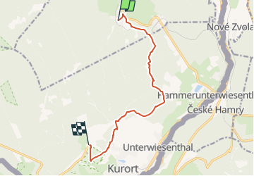
11,7 km | 16 km-effort
3h 38min
![](https://static1.geolcdn.com/siteimages/upload/files/16400158638029165_repeat_loop_refresh_sync_direction_icon.png)
Nein
![Tour Zu Fuß Oberwiesenthal - Ww Bächelhütte - Rittersgrün - Pöhla - Photo](https://media.geolcdn.com/t/375/260/ext.jpg?maxdim=2&url=https%3A%2F%2Fstatic1.geolcdn.com%2Fsiteimages%2Fupload%2Ffiles%2F1545311037marcheuse_200dpi.jpg)
![Zu Fuß Zu Fuß](https://static1.geolcdn.com/sitytour/trail-icons/100.png)
Ww Bächelhütte - Rittersgrün - Pöhla
Zu Fuß
Einfach
Oberwiesenthal,
Sachsen,
Erzgebirgskreis,
Germany
![](/images/other/stat-length.png)
14,9 km | 18 km-effort
4h 6min
![](https://static1.geolcdn.com/siteimages/upload/files/16400158638029165_repeat_loop_refresh_sync_direction_icon.png)
Nein
![Tour Zu Fuß Oberwiesenthal - Ww Rotes Vorwerk - Pförtelstraße - Photo](https://media.geolcdn.com/t/375/260/ext.jpg?maxdim=2&url=https%3A%2F%2Fstatic1.geolcdn.com%2Fsiteimages%2Fupload%2Ffiles%2F1545311037marcheuse_200dpi.jpg)
![Zu Fuß Zu Fuß](https://static1.geolcdn.com/sitytour/trail-icons/100.png)
Ww Rotes Vorwerk - Pförtelstraße
Zu Fuß
Einfach
Oberwiesenthal,
Sachsen,
Erzgebirgskreis,
Germany
![](/images/other/stat-length.png)
3,9 km | 5,2 km-effort
1h 10min
![](https://static1.geolcdn.com/siteimages/upload/files/16400158638029165_repeat_loop_refresh_sync_direction_icon.png)
Nein
![Tour Zu Fuß Bärenstein - Ww Bärenstein, Parkplatz am Fuße des Berges-Richtung Kretscham-Rothensehma - Photo](https://media.geolcdn.com/t/375/260/ext.jpg?maxdim=2&url=https%3A%2F%2Fstatic1.geolcdn.com%2Fsiteimages%2Fupload%2Ffiles%2F1545311037marcheuse_200dpi.jpg)
![Zu Fuß Zu Fuß](https://static1.geolcdn.com/sitytour/trail-icons/100.png)
Ww Bärenstein, Parkplatz am Fuße des Berges-Richtung Kretscham-Rothensehma
Zu Fuß
Einfach
Bärenstein,
Sachsen,
Erzgebirgskreis,
Germany
![](/images/other/stat-length.png)
4,1 km | 5,3 km-effort
1h 12min
![](https://static1.geolcdn.com/siteimages/upload/files/16400158638029165_repeat_loop_refresh_sync_direction_icon.png)
Nein
![Tour Zu Fuß Sehmatal - Ww Cranzahl-Bärenstein-Königswalde - Photo](https://media.geolcdn.com/t/375/260/ext.jpg?maxdim=2&url=https%3A%2F%2Fstatic1.geolcdn.com%2Fsiteimages%2Fupload%2Ffiles%2F1545311037marcheuse_200dpi.jpg)
![Zu Fuß Zu Fuß](https://static1.geolcdn.com/sitytour/trail-icons/100.png)
Ww Cranzahl-Bärenstein-Königswalde
Zu Fuß
Einfach
Sehmatal,
Sachsen,
Erzgebirgskreis,
Germany
![](/images/other/stat-length.png)
3,6 km | 5,7 km-effort
1h 17min
![](https://static1.geolcdn.com/siteimages/upload/files/16400158638029165_repeat_loop_refresh_sync_direction_icon.png)
Nein
![Tour Zu Fuß Sehmatal - Erlebnispfad Bimmelbahn - Photo](https://media.geolcdn.com/t/375/260/ext.jpg?maxdim=2&url=https%3A%2F%2Fstatic1.geolcdn.com%2Fsiteimages%2Fupload%2Ffiles%2F1545311037marcheuse_200dpi.jpg)
![Zu Fuß Zu Fuß](https://static1.geolcdn.com/sitytour/trail-icons/100.png)
Erlebnispfad Bimmelbahn
Zu Fuß
Einfach
Sehmatal,
Sachsen,
Erzgebirgskreis,
Germany
![](/images/other/stat-length.png)
6,2 km | 8 km-effort
1h 48min
![](https://static1.geolcdn.com/siteimages/upload/files/16400158638029165_repeat_loop_refresh_sync_direction_icon.png)
Nein
![Tour Zu Fuß Oberwiesenthal - Eric-Frenzel-Tour - Photo](https://media.geolcdn.com/t/375/260/ext.jpg?maxdim=2&url=https%3A%2F%2Fstatic1.geolcdn.com%2Fsiteimages%2Fupload%2Ffiles%2F1545311037marcheuse_200dpi.jpg)
![Zu Fuß Zu Fuß](https://static1.geolcdn.com/sitytour/trail-icons/100.png)
Eric-Frenzel-Tour
Zu Fuß
Einfach
Oberwiesenthal,
Sachsen,
Erzgebirgskreis,
Germany
![](/images/other/stat-length.png)
3,5 km | 5,2 km-effort
1h 11min
![](https://static1.geolcdn.com/siteimages/upload/files/16400158638029165_repeat_loop_refresh_sync_direction_icon.png)
Ja
![Tour Zu Fuß Sehmatal - Rund um Neudorf - Photo](https://media.geolcdn.com/t/375/260/ext.jpg?maxdim=2&url=https%3A%2F%2Fstatic1.geolcdn.com%2Fsiteimages%2Fupload%2Ffiles%2F1545311037marcheuse_200dpi.jpg)
![Zu Fuß Zu Fuß](https://static1.geolcdn.com/sitytour/trail-icons/100.png)
Rund um Neudorf
Zu Fuß
Einfach
Sehmatal,
Sachsen,
Erzgebirgskreis,
Germany
![](/images/other/stat-length.png)
11,6 km | 16,6 km-effort
3h 46min
![](https://static1.geolcdn.com/siteimages/upload/files/16400158638029165_repeat_loop_refresh_sync_direction_icon.png)
Nein