![](/images/other/stat-length.png)
![Tour Zu Fuß Unbekannt - Wanderweg 24 - Photo](https://media.geolcdn.com/t/1900/400/ext.pjpeg?maxdim=2&url=https%3A%2F%2Fmedia.geolcdn.com%2Ff%2F03744dda-f212-4e90-978c-ba8799e67dad.jpeg)
Wanderweg 24
SityTrail - itinéraires balisés pédestres
Tous les sentiers balisés d’Europe PRO
![Länge](/images/other/stat-length.png)
Länge
15,3 km
![Maximale Höhe](https://static1.geolcdn.com/siteimages/upload/files/1508320355ic_sort_altitude_max_24dp.png)
Maximale Höhe
126 m
![Positive Höhendifferenz](https://static1.geolcdn.com/siteimages/upload/files/1508320355ic_sort_den_pos_24dp.png)
Positive Höhendifferenz
248 m
![Km-Effort](/images/other/stat-length.png)
Km-Effort
18,5 km
![Min. Höhe](https://static1.geolcdn.com/siteimages/upload/files/1508320355ic_sort_altitude_min_24dp.png)
Min. Höhe
10 m
![Negative Höhendifferenz](https://static1.geolcdn.com/siteimages/upload/files/1508320355ic_sort_den_neg_24dp.png)
Negative Höhendifferenz
219 m
![Boucle](https://static1.geolcdn.com/siteimages/upload/files/16400158638029165_repeat_loop_refresh_sync_direction_icon.png)
Boucle
Nein
Kennzeichnung
Erstellungsdatum :
2022-02-11 14:41:58.73
Letzte Änderung :
2022-02-11 14:41:58.73
![Zu Fuß](https://static1.geolcdn.com/sitytour/trail-icons/100.png)
4h11
Schwierigkeit : Einfach
![Scannen Sie diesen QR-Code, um die Tour in der SityTrail-Anwendung zu öffnen](https://capi.geolives.com/qq0zvz2zws4bq2lad0pu/sitytour/trails/3093137/qr.png?size=200)
Kostenlosegpshiking-Anwendung
Über SityTrail
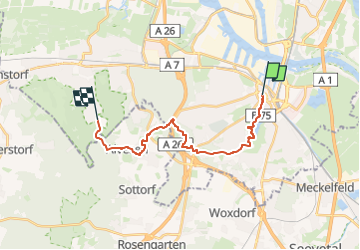
Tour Zu Fuß von 15,3 km verfügbar auf Hamburg, Unbekannt, Unbekannt. Diese Tour wird von SityTrail - itinéraires balisés pédestres vorgeschlagen.
Beschreibung
Trail created by Wanderverband Norddeutschland e.V..
Symbol: gelber Pfeil auf weissem Grund
Website: http://www.wanderverband-norddeutschland.de
Ort
Land:
Germany
Region :
Hamburg
Abteilung/Provinz :
Unbekannt
Kommune :
Unbekannt
Standort:
Harburg
Gehen Sie:(Dec)
Gehen Sie:(UTM)
565122 ; 5923867 (32U) N.
Kommentare
Touren in der Umgebung
![Tour Zu Fuß Unbekannt - Wanderweg Verbindungsweg HF-H - Photo](https://media.geolcdn.com/t/375/260/ext.jpg?maxdim=2&url=https%3A%2F%2Fmedia.geolcdn.com%2Ff%2F456ffa5a-8bbe-4077-905c-65704ac5cb42.jpeg)
![Zu Fuß Zu Fuß](https://static1.geolcdn.com/sitytour/trail-icons/100.png)
Wanderweg Verbindungsweg HF-H
Zu Fuß
Einfach
Unbekannt,
Hamburg,
Unbekannt,
Germany
![](/images/other/stat-length.png)
4,4 km | 5,3 km-effort
1h 11min
![](https://static1.geolcdn.com/siteimages/upload/files/16400158638029165_repeat_loop_refresh_sync_direction_icon.png)
Nein
![Tour Zu Fuß Unbekannt - Wander-Tour Harburger Berge - Photo](https://media.geolcdn.com/t/375/260/ext.jpg?maxdim=2&url=https%3A%2F%2Fmedia.geolcdn.com%2Ff%2F69152109-3ce8-403e-943f-dd0414299b48.jpeg)
![Zu Fuß Zu Fuß](https://static1.geolcdn.com/sitytour/trail-icons/100.png)
Wander-Tour Harburger Berge
Zu Fuß
Einfach
Unbekannt,
Hamburg,
Unbekannt,
Germany
![](/images/other/stat-length.png)
4,4 km | 5,4 km-effort
1h 13min
![](https://static1.geolcdn.com/siteimages/upload/files/16400158638029165_repeat_loop_refresh_sync_direction_icon.png)
Nein
![Tour Zu Fuß Unbekannt - Wanderweg KI-A - Photo](https://media.geolcdn.com/t/375/260/ext.jpg?maxdim=2&url=https%3A%2F%2Fmedia.geolcdn.com%2Ff%2Ff4a1f4e9-fd23-4f77-a0e3-1b351d02f82e.jpeg)
![Zu Fuß Zu Fuß](https://static1.geolcdn.com/sitytour/trail-icons/100.png)
Wanderweg KI-A
Zu Fuß
Einfach
Unbekannt,
Hamburg,
Unbekannt,
Germany
![](/images/other/stat-length.png)
4,6 km | 5,6 km-effort
1h 15min
![](https://static1.geolcdn.com/siteimages/upload/files/16400158638029165_repeat_loop_refresh_sync_direction_icon.png)
Nein
![Tour Zu Fuß Unbekannt - Wanderweg KA-A - Photo](https://media.geolcdn.com/t/375/260/ext.jpg?maxdim=2&url=https%3A%2F%2Fmedia.geolcdn.com%2Ff%2F6754b8db-6acb-4b11-b2da-87c0475c0759.jpeg)
![Zu Fuß Zu Fuß](https://static1.geolcdn.com/sitytour/trail-icons/100.png)
Wanderweg KA-A
Zu Fuß
Einfach
Unbekannt,
Hamburg,
Unbekannt,
Germany
![](/images/other/stat-length.png)
9,5 km | 11,4 km-effort
2h 35min
![](https://static1.geolcdn.com/siteimages/upload/files/16400158638029165_repeat_loop_refresh_sync_direction_icon.png)
Nein
![Tour Zu Fuß Unbekannt - Wanderweg A-H - Photo](https://media.geolcdn.com/t/375/260/ext.jpg?maxdim=2&url=https%3A%2F%2Fmedia.geolcdn.com%2Ff%2Ff4a1f4e9-fd23-4f77-a0e3-1b351d02f82e.jpeg)
![Zu Fuß Zu Fuß](https://static1.geolcdn.com/sitytour/trail-icons/100.png)
Wanderweg A-H
Zu Fuß
Einfach
Unbekannt,
Hamburg,
Unbekannt,
Germany
![](/images/other/stat-length.png)
6,3 km | 7,6 km-effort
1h 44min
![](https://static1.geolcdn.com/siteimages/upload/files/16400158638029165_repeat_loop_refresh_sync_direction_icon.png)
Nein
![Tour Zu Fuß Unbekannt - Wanderweg 23 - Photo](https://media.geolcdn.com/t/375/260/ext.jpg?maxdim=2&url=https%3A%2F%2Fmedia.geolcdn.com%2Ff%2F03744dda-f212-4e90-978c-ba8799e67dad.jpeg)
![Zu Fuß Zu Fuß](https://static1.geolcdn.com/sitytour/trail-icons/100.png)
Wanderweg 23
Zu Fuß
Einfach
Unbekannt,
Hamburg,
Unbekannt,
Germany
![](/images/other/stat-length.png)
6,7 km | 8,5 km-effort
1h 55min
![](https://static1.geolcdn.com/siteimages/upload/files/16400158638029165_repeat_loop_refresh_sync_direction_icon.png)
Nein
![Tour Zu Fuß Seevetal - Wanderweg RB - Photo](https://media.geolcdn.com/t/375/260/ext.jpg?maxdim=2&url=https%3A%2F%2Fmedia.geolcdn.com%2Ff%2Fe4c11625-58d8-4d36-a6b3-af711ad1adc0.jpeg)
![Zu Fuß Zu Fuß](https://static1.geolcdn.com/sitytour/trail-icons/100.png)
Wanderweg RB
Zu Fuß
Einfach
Seevetal,
Niedersachsen,
Harburg,
Germany
![](/images/other/stat-length.png)
6,3 km | 6,7 km-effort
1h 31min
![](https://static1.geolcdn.com/siteimages/upload/files/16400158638029165_repeat_loop_refresh_sync_direction_icon.png)
Nein
![Tour Zu Fuß Unbekannt - Stadtscheide - Photo](https://media.geolcdn.com/t/375/260/ext.jpg?maxdim=2&url=https%3A%2F%2Fmedia.geolcdn.com%2Ff%2Ff0e265c3-8db3-4fd9-aa11-4f9215289a1f.jpeg)
![Zu Fuß Zu Fuß](https://static1.geolcdn.com/sitytour/trail-icons/100.png)
![Tour sport Seevetal - Wanderparkplatz - Photo](https://media.geolcdn.com/t/375/260/ext.jpg?maxdim=2&url=https%3A%2F%2Fsecurestorage.geolives.com%2Fsitytour%2Ftrail-bg%2Fdefault.jpg)
Wanderparkplatz
sport
Sehr leicht
Seevetal,
Niedersachsen,
Harburg,
Germany
![](/images/other/stat-length.png)
12,9 km | 15,5 km-effort
Unbekannt
![](https://static1.geolcdn.com/siteimages/upload/files/16400158638029165_repeat_loop_refresh_sync_direction_icon.png)
Nein