![](/images/other/stat-length.png)
![Tour Zu Fuß Dallgow-Döberitz - Rundwanderweg Döberitzer Heide - Photo](https://media.geolcdn.com/t/1900/400/ext.pjpeg?maxdim=2&url=https%3A%2F%2Fmedia.geolcdn.com%2Ff%2Fc1c07f71-c6e5-4b48-928b-23d7825128d5.jpeg)
Rundwanderweg Döberitzer Heide
SityTrail - itinéraires balisés pédestres
Tous les sentiers balisés d’Europe PRO
![Länge](/images/other/stat-length.png)
Länge
21 km
![Maximale Höhe](https://static1.geolcdn.com/siteimages/upload/files/1508320355ic_sort_altitude_max_24dp.png)
Maximale Höhe
67 m
![Positive Höhendifferenz](https://static1.geolcdn.com/siteimages/upload/files/1508320355ic_sort_den_pos_24dp.png)
Positive Höhendifferenz
156 m
![Km-Effort](/images/other/stat-length.png)
Km-Effort
23 km
![Min. Höhe](https://static1.geolcdn.com/siteimages/upload/files/1508320355ic_sort_altitude_min_24dp.png)
Min. Höhe
31 m
![Negative Höhendifferenz](https://static1.geolcdn.com/siteimages/upload/files/1508320355ic_sort_den_neg_24dp.png)
Negative Höhendifferenz
154 m
![Boucle](https://static1.geolcdn.com/siteimages/upload/files/16400158638029165_repeat_loop_refresh_sync_direction_icon.png)
Boucle
Ja
Kennzeichnung
Erstellungsdatum :
2022-02-11 14:36:18.529
Letzte Änderung :
2022-02-11 14:36:18.529
![Zu Fuß](https://static1.geolcdn.com/sitytour/trail-icons/100.png)
5h19
Schwierigkeit : Medium
![Scannen Sie diesen QR-Code, um die Tour in der SityTrail-Anwendung zu öffnen](https://capi.geolives.com/qq0zvz2zws4bq2lad0pu/sitytour/trails/3092898/qr.png?size=200)
Kostenlosegpshiking-Anwendung
Über SityTrail
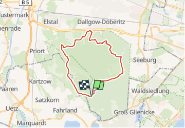
Tour Zu Fuß von 21 km verfügbar auf Brandenburg, Havelland, Dallgow-Döberitz. Diese Tour wird von SityTrail - itinéraires balisés pédestres vorgeschlagen.
Beschreibung
Trail created by Heinz Sielmann Stiftung.
Symbol: roter Punkt auf weißem Grund
Ort
Land:
Germany
Region :
Brandenburg
Abteilung/Provinz :
Havelland
Kommune :
Dallgow-Döberitz
Standort:
Unknown
Gehen Sie:(Dec)
Gehen Sie:(UTM)
367415 ; 5816183 (33U) N.
Kommentare
Touren in der Umgebung
![Tour Zu Fuß Unbekannt - Berlin. Wald. Klima. - Photo](https://media.geolcdn.com/t/375/260/ext.jpg?maxdim=2&url=https%3A%2F%2Fmedia.geolcdn.com%2Ff%2F430d6c71-fc41-4741-8e9d-c11d61ce722e.jpeg)
![Zu Fuß Zu Fuß](https://static1.geolcdn.com/sitytour/trail-icons/100.png)
Berlin. Wald. Klima.
Zu Fuß
Einfach
Unbekannt,
Berlin,
Unbekannt,
Germany
![](/images/other/stat-length.png)
3,4 km | 4,3 km-effort
58min
![](https://static1.geolcdn.com/siteimages/upload/files/16400158638029165_repeat_loop_refresh_sync_direction_icon.png)
Ja
![Tour Zu Fuß Stahnsdorf - BUGA 2001 - Photo](https://media.geolcdn.com/t/375/260/ext.jpg?maxdim=2&url=https%3A%2F%2Fmedia.geolcdn.com%2Ff%2F761eb142-464b-49f1-a6e3-8d60c797b3ff.jpeg)
![Zu Fuß Zu Fuß](https://static1.geolcdn.com/sitytour/trail-icons/100.png)
BUGA 2001
Zu Fuß
Einfach
Stahnsdorf,
Brandenburg,
Potsdam-Mittelmark,
Germany
![](/images/other/stat-length.png)
5,5 km | 6,1 km-effort
1h 22min
![](https://static1.geolcdn.com/siteimages/upload/files/16400158638029165_repeat_loop_refresh_sync_direction_icon.png)
Nein
![Tour Zu Fuß - (Grüner Punkt) - Photo](https://media.geolcdn.com/t/375/260/ext.jpg?maxdim=2&url=https%3A%2F%2Fmedia.geolcdn.com%2Ff%2Fca518d23-b630-495d-8b2d-f858844d326c.jpeg)
![Zu Fuß Zu Fuß](https://static1.geolcdn.com/sitytour/trail-icons/100.png)
![Tour Zu Fuß - Marquardt - Nedlitz - Photo](https://media.geolcdn.com/t/375/260/ext.jpg?maxdim=2&url=https%3A%2F%2Fmedia.geolcdn.com%2Ff%2F440405cd-d91a-43d6-b01a-85fdff20ad6c.jpeg)
![Zu Fuß Zu Fuß](https://static1.geolcdn.com/sitytour/trail-icons/100.png)
Marquardt - Nedlitz
Zu Fuß
Einfach
,
Brandenburg,
Potsdam,
Germany
![](/images/other/stat-length.png)
7,6 km | 8,4 km-effort
1h 54min
![](https://static1.geolcdn.com/siteimages/upload/files/16400158638029165_repeat_loop_refresh_sync_direction_icon.png)
Nein
![Tour Zu Fuß - Gelber Balken - IVV-Wanderweg 3 - Photo](https://media.geolcdn.com/t/375/260/ext.jpg?maxdim=2&url=https%3A%2F%2Fmedia.geolcdn.com%2Ff%2F9fc8e156-ab70-4f70-bea8-e9099e02be68.jpeg)
![Zu Fuß Zu Fuß](https://static1.geolcdn.com/sitytour/trail-icons/100.png)
Gelber Balken - IVV-Wanderweg 3
Zu Fuß
Einfach
,
Brandenburg,
Potsdam,
Germany
![](/images/other/stat-length.png)
5,2 km | 6 km-effort
1h 22min
![](https://static1.geolcdn.com/siteimages/upload/files/16400158638029165_repeat_loop_refresh_sync_direction_icon.png)
Nein
![Tour Zu Fuß Michendorf - Rundweg um Wilhelmshorst - Photo](https://media.geolcdn.com/t/375/260/ext.jpg?maxdim=2&url=https%3A%2F%2Fmedia.geolcdn.com%2Ff%2Fdd34d416-1a54-43fd-b4be-b6e9b6fe4694.jpeg)
![Zu Fuß Zu Fuß](https://static1.geolcdn.com/sitytour/trail-icons/100.png)
Rundweg um Wilhelmshorst
Zu Fuß
Einfach
Michendorf,
Brandenburg,
Potsdam-Mittelmark,
Germany
![](/images/other/stat-length.png)
8,6 km | 9,8 km-effort
2h 13min
![](https://static1.geolcdn.com/siteimages/upload/files/16400158638029165_repeat_loop_refresh_sync_direction_icon.png)
Ja
![Tour Zu Fuß - Wanderweg zum Kirchsteigfeld - Photo](https://media.geolcdn.com/t/375/260/ext.jpg?maxdim=2&url=https%3A%2F%2Fmedia.geolcdn.com%2Ff%2Fa3458829-98d7-4a96-994f-f70af3c0dec8.jpeg)
![Zu Fuß Zu Fuß](https://static1.geolcdn.com/sitytour/trail-icons/100.png)
Wanderweg zum Kirchsteigfeld
Zu Fuß
Einfach
,
Brandenburg,
Potsdam,
Germany
![](/images/other/stat-length.png)
4,3 km | 4,6 km-effort
1h 2min
![](https://static1.geolcdn.com/siteimages/upload/files/16400158638029165_repeat_loop_refresh_sync_direction_icon.png)
Nein
![Tour Zu Fuß - Kleine Wildpark-Route - Photo](https://media.geolcdn.com/t/375/260/ext.jpg?maxdim=2&url=https%3A%2F%2Fmedia.geolcdn.com%2Ff%2F9bb0f4ba-aecf-4422-9065-5b1e7cfc3d08.jpeg)
![Zu Fuß Zu Fuß](https://static1.geolcdn.com/sitytour/trail-icons/100.png)
Kleine Wildpark-Route
Zu Fuß
Einfach
,
Brandenburg,
Potsdam,
Germany
![](/images/other/stat-length.png)
3,3 km | 3,7 km-effort
50min
![](https://static1.geolcdn.com/siteimages/upload/files/16400158638029165_repeat_loop_refresh_sync_direction_icon.png)
Nein
![Tour Zu Fuß - Waldlehrpfad Pirschheide - Photo](https://media.geolcdn.com/t/375/260/ext.jpg?maxdim=2&url=https%3A%2F%2Fmedia.geolcdn.com%2Ff%2F9bb0f4ba-aecf-4422-9065-5b1e7cfc3d08.jpeg)
![Zu Fuß Zu Fuß](https://static1.geolcdn.com/sitytour/trail-icons/100.png)
Waldlehrpfad Pirschheide
Zu Fuß
Einfach
,
Brandenburg,
Potsdam,
Germany
![](/images/other/stat-length.png)
4,1 km | 4,6 km-effort
1h 2min
![](https://static1.geolcdn.com/siteimages/upload/files/16400158638029165_repeat_loop_refresh_sync_direction_icon.png)
Nein