![](/images/other/stat-length.png)
![Tour Zu Fuß Michelstadt - Rundwanderweg Steinbach 1: Rehbach-Weg - Photo](https://media.geolcdn.com/t/1900/400/ext.pjpeg?maxdim=2&url=https%3A%2F%2Fmedia.geolcdn.com%2Ff%2F08a807c3-4d7b-45bb-89da-638baa855bbb.jpeg)
Rundwanderweg Steinbach 1: Rehbach-Weg
SityTrail - itinéraires balisés pédestres
Tous les sentiers balisés d’Europe PRO
![Länge](/images/other/stat-length.png)
Länge
7,7 km
![Maximale Höhe](https://static1.geolcdn.com/siteimages/upload/files/1508320355ic_sort_altitude_max_24dp.png)
Maximale Höhe
398 m
![Positive Höhendifferenz](https://static1.geolcdn.com/siteimages/upload/files/1508320355ic_sort_den_pos_24dp.png)
Positive Höhendifferenz
213 m
![Km-Effort](/images/other/stat-length.png)
Km-Effort
10,5 km
![Min. Höhe](https://static1.geolcdn.com/siteimages/upload/files/1508320355ic_sort_altitude_min_24dp.png)
Min. Höhe
273 m
![Negative Höhendifferenz](https://static1.geolcdn.com/siteimages/upload/files/1508320355ic_sort_den_neg_24dp.png)
Negative Höhendifferenz
213 m
![Boucle](https://static1.geolcdn.com/siteimages/upload/files/16400158638029165_repeat_loop_refresh_sync_direction_icon.png)
Boucle
Ja
Kennzeichnung
Erstellungsdatum :
2022-02-11 14:15:00.07
Letzte Änderung :
2022-02-11 14:15:00.07
![Zu Fuß](https://static1.geolcdn.com/sitytour/trail-icons/100.png)
2h23
Schwierigkeit : Einfach
![Scannen Sie diesen QR-Code, um die Tour in der SityTrail-Anwendung zu öffnen](https://capi.geolives.com/qq0zvz2zws4bq2lad0pu/sitytour/trails/3092289/qr.png?size=200)
Kostenlosegpshiking-Anwendung
Über SityTrail
Tour Zu Fuß von 7,7 km verfügbar auf Hessen, Odenwaldkreis, Michelstadt. Diese Tour wird von SityTrail - itinéraires balisés pédestres vorgeschlagen.
Beschreibung
Trail created by Michelstadt.
Symbol: "St" über weißem Ring, "1" im weißen Ring
Ort
Land:
Germany
Region :
Hessen
Abteilung/Provinz :
Odenwaldkreis
Kommune :
Michelstadt
Standort:
Unknown
Gehen Sie:(Dec)
Gehen Sie:(UTM)
496426 ; 5503264 (32U) N.
Kommentare
Touren in der Umgebung
![Tour Zu Fuß Erbach - Rundwanderweg Erbach 2: - Photo](https://media.geolcdn.com/t/375/260/ext.jpg?maxdim=2&url=https%3A%2F%2Fmedia.geolcdn.com%2Ff%2Fc62c77d9-62fd-4bd6-a775-e1eb2b8297a7.jpeg)
![Zu Fuß Zu Fuß](https://static1.geolcdn.com/sitytour/trail-icons/100.png)
Rundwanderweg Erbach 2:
Zu Fuß
Einfach
Erbach,
Hessen,
Odenwaldkreis,
Germany
![](/images/other/stat-length.png)
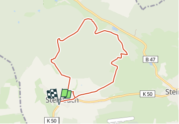
7,6 km | 10,4 km-effort
2h 21min
![](https://static1.geolcdn.com/siteimages/upload/files/16400158638029165_repeat_loop_refresh_sync_direction_icon.png)
Ja
![Tour Zu Fuß Reichelsheim (Odenwald) - Geo-Lehrpfad Ober-Kainsbach : Baustein, Erz und schwerer Spat (orange) - Photo](https://media.geolcdn.com/t/375/260/ext.jpg?maxdim=2&url=https%3A%2F%2Fmedia.geolcdn.com%2Ff%2F494567a9-965d-45a9-a6be-97c4d96bfdba.jpeg)
![Zu Fuß Zu Fuß](https://static1.geolcdn.com/sitytour/trail-icons/100.png)
Geo-Lehrpfad Ober-Kainsbach : Baustein, Erz und schwerer Spat (orange)
Zu Fuß
Einfach
Reichelsheim (Odenwald),
Hessen,
Odenwaldkreis,
Germany
![](/images/other/stat-length.png)
4,5 km | 5,9 km-effort
1h 19min
![](https://static1.geolcdn.com/siteimages/upload/files/16400158638029165_repeat_loop_refresh_sync_direction_icon.png)
Nein
![Tour Zu Fuß Michelstadt - Rundwanderweg Michelstadt Waldhorn 3: Silberbrünnchenweg - Photo](https://media.geolcdn.com/t/375/260/ext.jpg?maxdim=2&url=https%3A%2F%2Fmedia.geolcdn.com%2Ff%2F73d2951f-5d44-4953-a463-930469c7b118.jpeg)
![Zu Fuß Zu Fuß](https://static1.geolcdn.com/sitytour/trail-icons/100.png)
Rundwanderweg Michelstadt Waldhorn 3: Silberbrünnchenweg
Zu Fuß
Einfach
Michelstadt,
Hessen,
Odenwaldkreis,
Germany
![](/images/other/stat-length.png)
5,3 km | 7,2 km-effort
1h 37min
![](https://static1.geolcdn.com/siteimages/upload/files/16400158638029165_repeat_loop_refresh_sync_direction_icon.png)
Ja
![Tour Zu Fuß Reichelsheim (Odenwald) - Rundwanderweg Vierstöck 6: Knösberg-Weg - Photo](https://media.geolcdn.com/t/375/260/ext.jpg?maxdim=2&url=https%3A%2F%2Fmedia.geolcdn.com%2Ff%2F83832b04-129c-42f4-8f47-3dfb605b5b7f.jpeg)
![Zu Fuß Zu Fuß](https://static1.geolcdn.com/sitytour/trail-icons/100.png)
Rundwanderweg Vierstöck 6: Knösberg-Weg
Zu Fuß
Einfach
Reichelsheim (Odenwald),
Hessen,
Odenwaldkreis,
Germany
![](/images/other/stat-length.png)
3,3 km | 4,5 km-effort
1h 0min
![](https://static1.geolcdn.com/siteimages/upload/files/16400158638029165_repeat_loop_refresh_sync_direction_icon.png)
Ja
![Tour Zu Fuß Michelstadt - Rundwanderweg Michelstadt Einhard Quelle 2: Kühberg-Weg - Photo](https://media.geolcdn.com/t/375/260/ext.jpg?maxdim=2&url=https%3A%2F%2Fmedia.geolcdn.com%2Ff%2F6f017b49-450c-4de9-bda2-e7429ad654f7.jpeg)
![Zu Fuß Zu Fuß](https://static1.geolcdn.com/sitytour/trail-icons/100.png)
Rundwanderweg Michelstadt Einhard Quelle 2: Kühberg-Weg
Zu Fuß
Einfach
Michelstadt,
Hessen,
Odenwaldkreis,
Germany
![](/images/other/stat-length.png)
4,2 km | 5,4 km-effort
1h 13min
![](https://static1.geolcdn.com/siteimages/upload/files/16400158638029165_repeat_loop_refresh_sync_direction_icon.png)
Ja
![Tour Zu Fuß Erbach - Rundwanderweg Erbach 6 - Photo](https://media.geolcdn.com/t/375/260/ext.jpg?maxdim=2&url=https%3A%2F%2Fmedia.geolcdn.com%2Ff%2Ffcfaa305-a156-4cb0-9f6f-d5e74e8bf0e1.jpeg)
![Zu Fuß Zu Fuß](https://static1.geolcdn.com/sitytour/trail-icons/100.png)
Rundwanderweg Erbach 6
Zu Fuß
Einfach
Erbach,
Hessen,
Odenwaldkreis,
Germany
![](/images/other/stat-length.png)
14,4 km | 19,2 km-effort
4h 22min
![](https://static1.geolcdn.com/siteimages/upload/files/16400158638029165_repeat_loop_refresh_sync_direction_icon.png)
Ja
![Tour Zu Fuß Brombachtal - Rundwanderweg Zell 4 : Brombach-Weg - Photo](https://media.geolcdn.com/t/375/260/ext.jpg?maxdim=2&url=https%3A%2F%2Fmedia.geolcdn.com%2Ff%2F1ada811f-58d1-42f9-9572-b3fbda86272d.jpeg)
![Zu Fuß Zu Fuß](https://static1.geolcdn.com/sitytour/trail-icons/100.png)
Rundwanderweg Zell 4 : Brombach-Weg
Zu Fuß
Einfach
Brombachtal,
Hessen,
Odenwaldkreis,
Germany
![](/images/other/stat-length.png)
6,1 km | 8,5 km-effort
1h 55min
![](https://static1.geolcdn.com/siteimages/upload/files/16400158638029165_repeat_loop_refresh_sync_direction_icon.png)
Ja
![Tour Zu Fuß Michelstadt - Rundwanderweg Brombachtal 5 - Photo](https://media.geolcdn.com/t/375/260/ext.jpg?maxdim=2&url=https%3A%2F%2Fmedia.geolcdn.com%2Ff%2Fb22a1b6b-db57-4bd5-b2b6-b9d0d9584599.jpeg)
![Zu Fuß Zu Fuß](https://static1.geolcdn.com/sitytour/trail-icons/100.png)
Rundwanderweg Brombachtal 5
Zu Fuß
Einfach
Michelstadt,
Hessen,
Odenwaldkreis,
Germany
![](/images/other/stat-length.png)
6 km | 7,3 km-effort
1h 40min
![](https://static1.geolcdn.com/siteimages/upload/files/16400158638029165_repeat_loop_refresh_sync_direction_icon.png)
Nein
![Tour Zu Fuß Brombachtal - Rundwanderweg Brombachtal 3 - Photo](https://media.geolcdn.com/t/375/260/ext.jpg?maxdim=2&url=https%3A%2F%2Fmedia.geolcdn.com%2Ff%2F1ada811f-58d1-42f9-9572-b3fbda86272d.jpeg)
![Zu Fuß Zu Fuß](https://static1.geolcdn.com/sitytour/trail-icons/100.png)
Rundwanderweg Brombachtal 3
Zu Fuß
Einfach
Brombachtal,
Hessen,
Odenwaldkreis,
Germany
![](/images/other/stat-length.png)
6 km | 8 km-effort
1h 48min
![](https://static1.geolcdn.com/siteimages/upload/files/16400158638029165_repeat_loop_refresh_sync_direction_icon.png)
Ja