![](/images/other/stat-length.png)
![Tour Zu Fuß Bornheim - Ville A39 - Photo](https://media.geolcdn.com/t/1900/400/61965ebe-2f4a-433a-9e04-4c7f01a0817c.jpeg&format=pjpeg&maxdim=2)
Ville A39
SityTrail - itinéraires balisés pédestres
Tous les sentiers balisés d’Europe GUIDE+
![Länge](/images/other/stat-length.png)
Länge
6,9 km
![Maximale Höhe](https://static1.geolcdn.com/siteimages/upload/files/1508320355ic_sort_altitude_max_24dp.png)
Maximale Höhe
183 m
![Positive Höhendifferenz](https://static1.geolcdn.com/siteimages/upload/files/1508320355ic_sort_den_pos_24dp.png)
Positive Höhendifferenz
88 m
![Km-Effort](/images/other/stat-length.png)
Km-Effort
8,1 km
![Min. Höhe](https://static1.geolcdn.com/siteimages/upload/files/1508320355ic_sort_altitude_min_24dp.png)
Min. Höhe
141 m
![Negative Höhendifferenz](https://static1.geolcdn.com/siteimages/upload/files/1508320355ic_sort_den_neg_24dp.png)
Negative Höhendifferenz
87 m
![Boucle](https://static1.geolcdn.com/siteimages/upload/files/16400158638029165_repeat_loop_refresh_sync_direction_icon.png)
Boucle
Ja
Kennzeichnung
Erstellungsdatum :
2022-02-11 14:12:34.151
Letzte Änderung :
2022-02-11 14:12:34.151
![Zu Fuß](https://static1.geolcdn.com/sitytour/trail-icons/100.png)
1h50
Schwierigkeit : Einfach
![Scannen Sie diesen QR-Code, um die Tour in der SityTrail-Anwendung zu öffnen](https://capi.geolives.com/qq0zvz2zws4bq2lad0pu/sitytour/trails/3092226/qr.png?size=200)
Kostenlosegpshiking-Anwendung
Über SityTrail
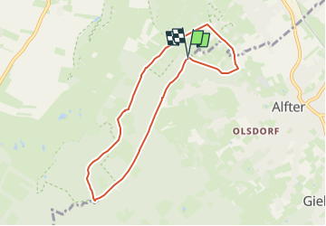
Tour Zu Fuß von 6,9 km verfügbar auf Nordrhein-Westfalen, Rhein-Sieg-Kreis, Bornheim. Diese Tour wird von SityTrail - itinéraires balisés pédestres vorgeschlagen.
Beschreibung
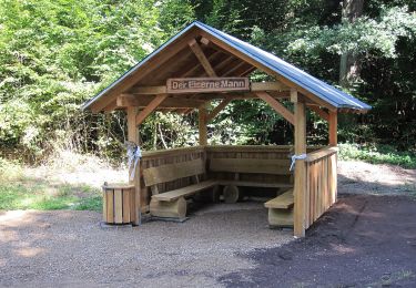
Trail created by Naturpark Rheinland.
Wanderwegmarkierung kaum noch auffindbar
Symbol: schwarze Schrift A39 auf schwarzem Grund
Ort
Land:
Germany
Region :
Nordrhein-Westfalen
Abteilung/Provinz :
Rhein-Sieg-Kreis
Kommune :
Bornheim
Standort:
Unknown
Gehen Sie:(Dec)
Gehen Sie:(UTM)
358198 ; 5623143 (32U) N.
Kommentare
Touren in der Umgebung
![Tour Zu Fuß Swisttal - Waldvilleweg - Photo](https://media.geolcdn.com/t/375/260/79a03d4a-5176-4be4-a37f-10f4ea281463.jpeg&format=jpg&maxdim=2)
![Zu Fuß Zu Fuß](https://static1.geolcdn.com/sitytour/trail-icons/100.png)
Waldvilleweg
Zu Fuß
Einfach
Swisttal,
Nordrhein-Westfalen,
Rhein-Sieg-Kreis,
Germany
![](/images/other/stat-length.png)
5,2 km | 5,9 km-effort
1h 21min
![](https://static1.geolcdn.com/siteimages/upload/files/16400158638029165_repeat_loop_refresh_sync_direction_icon.png)
Nein
![Tour Zu Fuß Alfter - Ville A40 Olsdorf - Photo](https://media.geolcdn.com/t/375/260/945b672f-b3c5-4551-89fc-783e5a7e7283.jpeg&format=jpg&maxdim=2)
![Zu Fuß Zu Fuß](https://static1.geolcdn.com/sitytour/trail-icons/100.png)
Ville A40 Olsdorf
Zu Fuß
Einfach
Alfter,
Nordrhein-Westfalen,
Rhein-Sieg-Kreis,
Germany
![](/images/other/stat-length.png)
6,1 km | 7,5 km-effort
1h 42min
![](https://static1.geolcdn.com/siteimages/upload/files/16400158638029165_repeat_loop_refresh_sync_direction_icon.png)
Ja
![Tour Zu Fuß Swisttal - Ville A34 - Photo](https://media.geolcdn.com/t/375/260/bf934722-1811-4e04-b6d3-bb31340dc346.jpeg&format=jpg&maxdim=2)
![Zu Fuß Zu Fuß](https://static1.geolcdn.com/sitytour/trail-icons/100.png)
Ville A34
Zu Fuß
Einfach
Swisttal,
Nordrhein-Westfalen,
Rhein-Sieg-Kreis,
Germany
![](/images/other/stat-length.png)
7,6 km | 8,4 km-effort
1h 54min
![](https://static1.geolcdn.com/siteimages/upload/files/16400158638029165_repeat_loop_refresh_sync_direction_icon.png)
Ja
![Tour Zu Fuß Swisttal - Ville A36 - Photo](https://media.geolcdn.com/t/375/260/bf934722-1811-4e04-b6d3-bb31340dc346.jpeg&format=jpg&maxdim=2)
![Zu Fuß Zu Fuß](https://static1.geolcdn.com/sitytour/trail-icons/100.png)
Ville A36
Zu Fuß
Einfach
Swisttal,
Nordrhein-Westfalen,
Rhein-Sieg-Kreis,
Germany
![](/images/other/stat-length.png)
8,6 km | 9,5 km-effort
2h 9min
![](https://static1.geolcdn.com/siteimages/upload/files/16400158638029165_repeat_loop_refresh_sync_direction_icon.png)
Ja