![](/images/other/stat-length.png)
![Tour Wandern Saint-Côme-et-Maruéjols - Maruejols et oppidum - Photo](https://media.geolcdn.com/t/1900/400/da0b123e-c23c-456f-b851-b738309e2f29.jpg&format=pjpeg&maxdim=2)
Maruejols et oppidum
v.rabot
Benutzer
![Länge](/images/other/stat-length.png)
![Maximale Höhe](https://static1.geolcdn.com/siteimages/upload/files/1508320355ic_sort_altitude_max_24dp.png)
![Positive Höhendifferenz](https://static1.geolcdn.com/siteimages/upload/files/1508320355ic_sort_den_pos_24dp.png)
![Km-Effort](/images/other/stat-length.png)
![Min. Höhe](https://static1.geolcdn.com/siteimages/upload/files/1508320355ic_sort_altitude_min_24dp.png)
![Negative Höhendifferenz](https://static1.geolcdn.com/siteimages/upload/files/1508320355ic_sort_den_neg_24dp.png)
![Boucle](https://static1.geolcdn.com/siteimages/upload/files/16400158638029165_repeat_loop_refresh_sync_direction_icon.png)
![Wandern](https://static1.geolcdn.com/sitytour/trail-icons/101.png)
5h28
Schwierigkeit : Medium
![Scannen Sie diesen QR-Code, um die Tour in der SityTrail-Anwendung zu öffnen](https://capi.geolives.com/qq0zvz2zws4bq2lad0pu/sitytour/trails/3091806/qr.png?size=200)
Kostenlosegpshiking-Anwendung
Über SityTrail
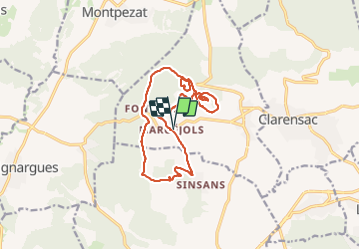
Tour Wandern von 15,5 km verfügbar auf Okzitanien, Gard, Saint-Côme-et-Maruéjols. Diese Tour wird von v.rabot vorgeschlagen.
Beschreibung
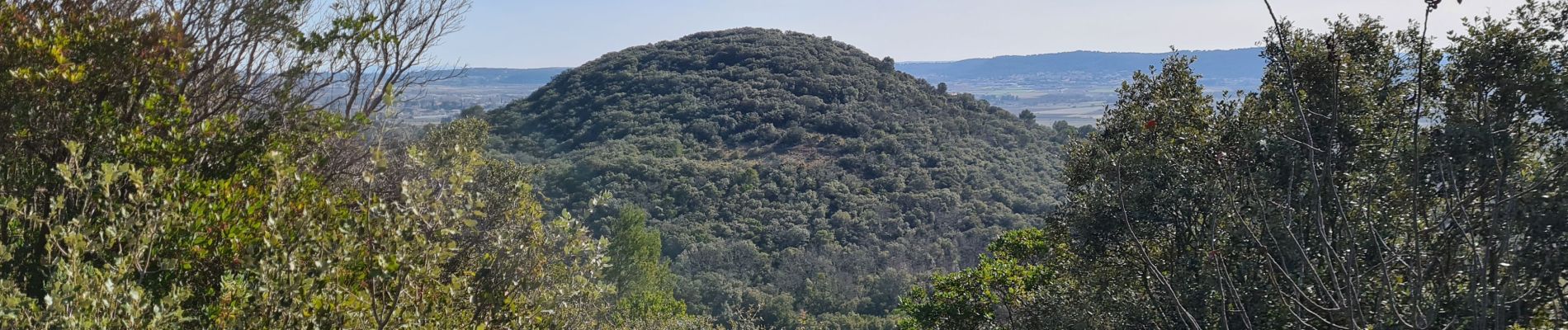
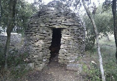
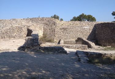
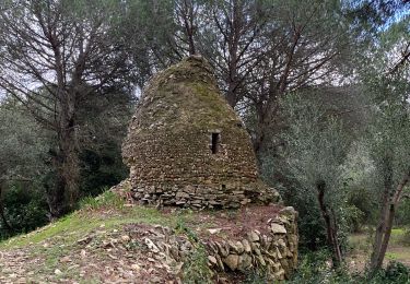
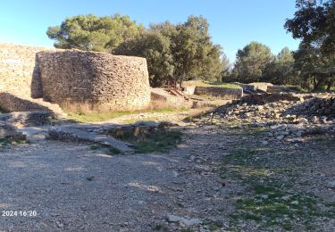
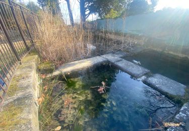
Partant de Maruéjols à 9h30, on rejoint l'entrée de Sisans par un chemin bordé de murs de pierres séches, la pente vers le plateau n'est pas trop dure, visite de la Capitelle du prieuré, pause café, Le tour du Pic Méjean permet d'avoir de belles vues sur la vallée, passage aux nombreux puits citernes pour rejoindre l'oppidum à 12h30, pause déjeuner, puis redescente en faisant le tour de l'oppidum par le Sud ce qui permet de voir la garenne enterrée et une capitelle avant de traverser le bois sacré sur des chemins non représentés sur la carte. Dernière pause à Fontaran avant de rejoindre la voiture à 15h00
Ort
Kommentare
Touren in der Umgebung
![Tour Wandern Saint-Côme-et-Maruéjols - St côtés et maruejols - Photo](https://media.geolcdn.com/t/375/260/ext.jpg?maxdim=2&url=https%3A%2F%2Fservices.sitytrail.com%2FGeolivesWS%2FDownloadMedia.ashx%3FTrailID%3D981964%26Media%3Dfix__20180607151110.jpg)
![Wandern Wandern](https://static1.geolcdn.com/sitytour/trail-icons/101.png)
Wandern
![](/images/other/stat-length.png)
![](https://static1.geolcdn.com/siteimages/upload/files/16400158638029165_repeat_loop_refresh_sync_direction_icon.png)
![Tour Mountainbike Calvisson - Espace VTT-FFC Pays de Sommières n°7 - Les Châteaux du Sommiérois - Photo](https://media.geolcdn.com/t/375/260/ext.jpg?maxdim=2&url=https%3A%2F%2Fservices.sitytrail.com%2FGeolivesWS%2FDownloadMedia.ashx%3FTrailID%3D191542%26Media%3D15154_2.jpg)
![Mountainbike Mountainbike](https://static1.geolcdn.com/sitytour/trail-icons/202.png)
Mountainbike
![](/images/other/stat-length.png)
![](https://static1.geolcdn.com/siteimages/upload/files/16400158638029165_repeat_loop_refresh_sync_direction_icon.png)
![Tour Wandern Saint-Dionisy - Opidum de Nages - Photo](https://media.geolcdn.com/t/375/260/ext.jpg?maxdim=2&url=https%3A%2F%2Fservices.sitytrail.com%2FGeolivesWS%2FDownloadMedia.ashx%3FTrailID%3D179053%26Media%3D20130310101940.jpeg)
![Wandern Wandern](https://static1.geolcdn.com/sitytour/trail-icons/101.png)
Wandern
![](/images/other/stat-length.png)
![](https://static1.geolcdn.com/siteimages/upload/files/16400158638029165_repeat_loop_refresh_sync_direction_icon.png)
![Tour Wandern Nages-et-Solorgues - 30 nages et solorgues langlade - Photo](https://media.geolcdn.com/t/375/260/54403abb-32b0-4d84-b2e8-3035fceb74a8.jpg&format=jpg&maxdim=2)
![Wandern Wandern](https://static1.geolcdn.com/sitytour/trail-icons/101.png)
Wandern
![](/images/other/stat-length.png)
![](https://static1.geolcdn.com/siteimages/upload/files/16400158638029165_repeat_loop_refresh_sync_direction_icon.png)
![Tour Wandern Langlade - NAGES ET SOLORGUES - LA GRAND COMBE - 16.5Km - 04h30 - Dénivelé 340 m - Photo](https://media.geolcdn.com/t/375/260/ext.jpg?maxdim=2&url=https%3A%2F%2Fstatic1.geolcdn.com%2Fsiteimages%2Fupload%2Ffiles%2F1553511878bg_sport_marche.png)
![Wandern Wandern](https://static1.geolcdn.com/sitytour/trail-icons/101.png)
Wandern
![](/images/other/stat-length.png)
![](https://static1.geolcdn.com/siteimages/upload/files/16400158638029165_repeat_loop_refresh_sync_direction_icon.png)
![Tour Wandern Calvisson - Calvisson - Photo](https://media.geolcdn.com/t/375/260/23f74a8e-99cc-4cea-8226-c6e36d48ea64.jpg&format=jpg&maxdim=2)
![Wandern Wandern](https://static1.geolcdn.com/sitytour/trail-icons/101.png)
Wandern
![](/images/other/stat-length.png)
![](https://static1.geolcdn.com/siteimages/upload/files/16400158638029165_repeat_loop_refresh_sync_direction_icon.png)
![Tour Wandern Nages-et-Solorgues - nages-langlades - Photo](https://media.geolcdn.com/t/375/260/544f9b35-ffc3-4030-aaef-31d1a8dd2266.jpg&format=jpg&maxdim=2)
![Wandern Wandern](https://static1.geolcdn.com/sitytour/trail-icons/101.png)
Wandern
![](/images/other/stat-length.png)
![](https://static1.geolcdn.com/siteimages/upload/files/16400158638029165_repeat_loop_refresh_sync_direction_icon.png)
![Tour Wandern Souvignargues - Saint Étienne d’Escattes - Photo](https://media.geolcdn.com/t/375/260/6ce50ea5-3ea7-4e07-837b-3824cc012ab2.jpg&format=jpg&maxdim=2)
![Wandern Wandern](https://static1.geolcdn.com/sitytour/trail-icons/101.png)
Wandern
![](/images/other/stat-length.png)
![](https://static1.geolcdn.com/siteimages/upload/files/16400158638029165_repeat_loop_refresh_sync_direction_icon.png)
![Tour Wandern Combas - Combas - Photo](https://media.geolcdn.com/t/375/260/02dbc83b-be1c-4bf6-a717-854391d9e59e.jpg&format=jpg&maxdim=2)
![Wandern Wandern](https://static1.geolcdn.com/sitytour/trail-icons/101.png)