![](/images/other/stat-length.png)
![Tour Zu Fuß Wadern - Hannejuschtweg - Photo](https://media.geolcdn.com/t/1900/400/84dbe70d-9d61-4cd6-8ea6-dd4f7a31e9fb.jpeg&format=pjpeg&maxdim=2)
Hannejuschtweg
SityTrail - itinéraires balisés pédestres
Tous les sentiers balisés d’Europe GUIDE+
![Länge](/images/other/stat-length.png)
Länge
18,9 km
![Maximale Höhe](https://static1.geolcdn.com/siteimages/upload/files/1508320355ic_sort_altitude_max_24dp.png)
Maximale Höhe
395 m
![Positive Höhendifferenz](https://static1.geolcdn.com/siteimages/upload/files/1508320355ic_sort_den_pos_24dp.png)
Positive Höhendifferenz
467 m
![Km-Effort](/images/other/stat-length.png)
Km-Effort
25 km
![Min. Höhe](https://static1.geolcdn.com/siteimages/upload/files/1508320355ic_sort_altitude_min_24dp.png)
Min. Höhe
243 m
![Negative Höhendifferenz](https://static1.geolcdn.com/siteimages/upload/files/1508320355ic_sort_den_neg_24dp.png)
Negative Höhendifferenz
471 m
![Boucle](https://static1.geolcdn.com/siteimages/upload/files/16400158638029165_repeat_loop_refresh_sync_direction_icon.png)
Boucle
Ja
Kennzeichnung
Erstellungsdatum :
2022-02-11 14:00:36.003
Letzte Änderung :
2022-02-11 14:00:36.003
![Zu Fuß](https://static1.geolcdn.com/sitytour/trail-icons/100.png)
5h42
Schwierigkeit : Medium
![Scannen Sie diesen QR-Code, um die Tour in der SityTrail-Anwendung zu öffnen](https://capi.geolives.com/qq0zvz2zws4bq2lad0pu/sitytour/trails/3091745/qr.png?size=200)
Kostenlosegpshiking-Anwendung
Über SityTrail
Tour Zu Fuß von 18,9 km verfügbar auf Saarland, Landkreis Merzig-Wadern, Wadern. Diese Tour wird von SityTrail - itinéraires balisés pédestres vorgeschlagen.
Beschreibung
Symbol: Stilisiertes schwarzes H auf gelbem Hintergrund
Ort
Land:
Germany
Region :
Saarland
Abteilung/Provinz :
Landkreis Merzig-Wadern
Kommune :
Wadern
Standort:
Nunkirchen
Gehen Sie:(Dec)
Gehen Sie:(UTM)
342787 ; 5482883 (32U) N.
Kommentare
Touren in der Umgebung
![Tour Zu Fuß Schmelz - Erzgräberweg - Photo](https://media.geolcdn.com/t/375/260/ac3a4bde-4679-4ec7-ba81-58e8aadf6631.jpeg&format=jpg&maxdim=2)
![Zu Fuß Zu Fuß](https://static1.geolcdn.com/sitytour/trail-icons/100.png)
Erzgräberweg
Zu Fuß
Einfach
Schmelz,
Saarland,
Landkreis Saarlouis,
Germany
![](/images/other/stat-length.png)
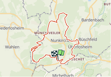
11,2 km | 16,1 km-effort
3h 39min
![](https://static1.geolcdn.com/siteimages/upload/files/16400158638029165_repeat_loop_refresh_sync_direction_icon.png)
Ja
![Tour Zu Fuß Wadern - Forsthofrunde - Photo](https://media.geolcdn.com/t/375/260/84dbe70d-9d61-4cd6-8ea6-dd4f7a31e9fb.jpeg&format=jpg&maxdim=2)
![Zu Fuß Zu Fuß](https://static1.geolcdn.com/sitytour/trail-icons/100.png)
Forsthofrunde
Zu Fuß
Einfach
Wadern,
Saarland,
Landkreis Merzig-Wadern,
Germany
![](/images/other/stat-length.png)
6,4 km | 8,7 km-effort
1h 58min
![](https://static1.geolcdn.com/siteimages/upload/files/16400158638029165_repeat_loop_refresh_sync_direction_icon.png)
Ja
![Tour Zu Fuß Wadern - Schloss Münchweiler Weg - Photo](https://media.geolcdn.com/t/375/260/84dbe70d-9d61-4cd6-8ea6-dd4f7a31e9fb.jpeg&format=jpg&maxdim=2)
![Zu Fuß Zu Fuß](https://static1.geolcdn.com/sitytour/trail-icons/100.png)
Schloss Münchweiler Weg
Zu Fuß
Medium
Wadern,
Saarland,
Landkreis Merzig-Wadern,
Germany
![](/images/other/stat-length.png)
16,5 km | 20 km-effort
4h 39min
![](https://static1.geolcdn.com/siteimages/upload/files/16400158638029165_repeat_loop_refresh_sync_direction_icon.png)
Ja
![Tour Zu Fuß Schmelz - LC Schmelz Laufstrecke 3 - Photo](https://media.geolcdn.com/t/375/260/7634c896-869d-4279-a009-22c16b5d1346.jpeg&format=jpg&maxdim=2)
![Zu Fuß Zu Fuß](https://static1.geolcdn.com/sitytour/trail-icons/100.png)
LC Schmelz Laufstrecke 3
Zu Fuß
Einfach
Schmelz,
Saarland,
Landkreis Saarlouis,
Germany
![](/images/other/stat-length.png)
11,9 km | 15,1 km-effort
3h 25min
![](https://static1.geolcdn.com/siteimages/upload/files/16400158638029165_repeat_loop_refresh_sync_direction_icon.png)
Ja
![Tour Zu Fuß Wadern - Lücknerweg - Photo](https://media.geolcdn.com/t/375/260/84dbe70d-9d61-4cd6-8ea6-dd4f7a31e9fb.jpeg&format=jpg&maxdim=2)
![Zu Fuß Zu Fuß](https://static1.geolcdn.com/sitytour/trail-icons/100.png)
Lücknerweg
Zu Fuß
Medium
Wadern,
Saarland,
Landkreis Merzig-Wadern,
Germany
![](/images/other/stat-length.png)
16,1 km | 22 km-effort
4h 56min
![](https://static1.geolcdn.com/siteimages/upload/files/16400158638029165_repeat_loop_refresh_sync_direction_icon.png)
Nein
![Tour Zu Fuß Schmelz - LC Schmelz Brauhauslauf - Photo](https://media.geolcdn.com/t/375/260/5c5b8203-2570-456c-bfe7-9fce64925034.jpeg&format=jpg&maxdim=2)
![Zu Fuß Zu Fuß](https://static1.geolcdn.com/sitytour/trail-icons/100.png)
LC Schmelz Brauhauslauf
Zu Fuß
Einfach
Schmelz,
Saarland,
Landkreis Saarlouis,
Germany
![](/images/other/stat-length.png)
5,1 km | 6,9 km-effort
1h 33min
![](https://static1.geolcdn.com/siteimages/upload/files/16400158638029165_repeat_loop_refresh_sync_direction_icon.png)
Ja
![Tour Zu Fuß Wadern - Bardenbacher Felsenweg - Photo](https://media.geolcdn.com/t/375/260/bc33d8bc-2679-48bc-b59c-fca51e4ebebb.jpeg&format=jpg&maxdim=2)
![Zu Fuß Zu Fuß](https://static1.geolcdn.com/sitytour/trail-icons/100.png)
Bardenbacher Felsenweg
Zu Fuß
Einfach
Wadern,
Saarland,
Landkreis Merzig-Wadern,
Germany
![](/images/other/stat-length.png)
3,2 km | 4,3 km-effort
58min
![](https://static1.geolcdn.com/siteimages/upload/files/16400158638029165_repeat_loop_refresh_sync_direction_icon.png)
Ja
![Tour Zu Fuß Losheim am See - Kleiner Lücknerweg - Photo](https://media.geolcdn.com/t/375/260/ext.jpg?maxdim=2&url=https%3A%2F%2Fstatic1.geolcdn.com%2Fsiteimages%2Fupload%2Ffiles%2F1545311037marcheuse_200dpi.jpg)
![Zu Fuß Zu Fuß](https://static1.geolcdn.com/sitytour/trail-icons/100.png)
Kleiner Lücknerweg
Zu Fuß
Einfach
Losheim am See,
Saarland,
Landkreis Merzig-Wadern,
Germany
![](/images/other/stat-length.png)
8,4 km | 11,1 km-effort
2h 31min
![](https://static1.geolcdn.com/siteimages/upload/files/16400158638029165_repeat_loop_refresh_sync_direction_icon.png)
Ja