![](/images/other/stat-length.png)
![Tour Zu Fuß Bendorf - Saynsteig - Photo](https://media.geolcdn.com/t/1900/400/889c5612-95e0-4a0e-99d7-6252f0771867.jpeg&format=pjpeg&maxdim=2)
Saynsteig
SityTrail - itinéraires balisés pédestres
Tous les sentiers balisés d’Europe GUIDE+
![Länge](/images/other/stat-length.png)
Länge
7,4 km
![Maximale Höhe](https://static1.geolcdn.com/siteimages/upload/files/1508320355ic_sort_altitude_max_24dp.png)
Maximale Höhe
332 m
![Positive Höhendifferenz](https://static1.geolcdn.com/siteimages/upload/files/1508320355ic_sort_den_pos_24dp.png)
Positive Höhendifferenz
289 m
![Km-Effort](/images/other/stat-length.png)
Km-Effort
10,9 km
![Min. Höhe](https://static1.geolcdn.com/siteimages/upload/files/1508320355ic_sort_altitude_min_24dp.png)
Min. Höhe
127 m
![Negative Höhendifferenz](https://static1.geolcdn.com/siteimages/upload/files/1508320355ic_sort_den_neg_24dp.png)
Negative Höhendifferenz
207 m
![Boucle](https://static1.geolcdn.com/siteimages/upload/files/16400158638029165_repeat_loop_refresh_sync_direction_icon.png)
Boucle
Nein
Kennzeichnung
Erstellungsdatum :
2022-02-11 13:54:58.414
Letzte Änderung :
2022-02-11 13:54:58.414
![Zu Fuß](https://static1.geolcdn.com/sitytour/trail-icons/100.png)
2h29
Schwierigkeit : Einfach
![Scannen Sie diesen QR-Code, um die Tour in der SityTrail-Anwendung zu öffnen](https://capi.geolives.com/qq0zvz2zws4bq2lad0pu/sitytour/trails/3091508/qr.png?size=200)
Kostenlosegpshiking-Anwendung
Über SityTrail
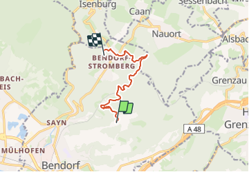
Tour Zu Fuß von 7,4 km verfügbar auf Rheinland-Pfalz, Landkreis Mayen-Koblenz, Bendorf. Diese Tour wird von SityTrail - itinéraires balisés pédestres vorgeschlagen.
Beschreibung
Trail created by Projektbüro Traumpfade der Rhein-Mosel-Eifel-Touristik.
Symbol: Orangener Hintergrund mit weißem Weg - Traumpfade
Ort
Land:
Germany
Region :
Rheinland-Pfalz
Abteilung/Provinz :
Landkreis Mayen-Koblenz
Kommune :
Bendorf
Standort:
Unknown
Gehen Sie:(Dec)
Gehen Sie:(UTM)
400653 ; 5588208 (32U) N.
Kommentare
Touren in der Umgebung
![Tour Zu Fuß Neuwied - Rheinsteig-Zuweg Engers - Photo](https://media.geolcdn.com/t/375/260/7350b576-8a8a-4526-8ce1-c84a52f2df87.jpeg&format=jpg&maxdim=2)
![Zu Fuß Zu Fuß](https://static1.geolcdn.com/sitytour/trail-icons/100.png)
Rheinsteig-Zuweg Engers
Zu Fuß
Einfach
Neuwied,
Rheinland-Pfalz,
Landkreis Neuwied,
Germany
![](/images/other/stat-length.png)
5,8 km | 6,5 km-effort
1h 28min
![](https://static1.geolcdn.com/siteimages/upload/files/16400158638029165_repeat_loop_refresh_sync_direction_icon.png)
Nein
![Tour Zu Fuß Bendorf - Wäller Tour Brexbachschluchtweg - Photo](https://media.geolcdn.com/t/375/260/889c5612-95e0-4a0e-99d7-6252f0771867.jpeg&format=jpg&maxdim=2)
![Zu Fuß Zu Fuß](https://static1.geolcdn.com/sitytour/trail-icons/100.png)
Wäller Tour Brexbachschluchtweg
Zu Fuß
Einfach
Bendorf,
Rheinland-Pfalz,
Landkreis Mayen-Koblenz,
Germany
![](/images/other/stat-length.png)
10,9 km | 14,7 km-effort
3h 20min
![](https://static1.geolcdn.com/siteimages/upload/files/16400158638029165_repeat_loop_refresh_sync_direction_icon.png)
Nein
![Tour Zu Fuß Vallendar - Wanderweg 09 - Photo](https://media.geolcdn.com/t/375/260/499e3973-01a4-4715-904b-f334c50f96e1.jpeg&format=jpg&maxdim=2)
![Zu Fuß Zu Fuß](https://static1.geolcdn.com/sitytour/trail-icons/100.png)
Wanderweg 09
Zu Fuß
Einfach
Vallendar,
Rheinland-Pfalz,
Landkreis Mayen-Koblenz,
Germany
![](/images/other/stat-length.png)
8,5 km | 11,2 km-effort
2h 32min
![](https://static1.geolcdn.com/siteimages/upload/files/16400158638029165_repeat_loop_refresh_sync_direction_icon.png)
Ja
![Tour Zu Fuß Vallendar - Waldschluchtenweg - Photo](https://media.geolcdn.com/t/375/260/499e3973-01a4-4715-904b-f334c50f96e1.jpeg&format=jpg&maxdim=2)
![Zu Fuß Zu Fuß](https://static1.geolcdn.com/sitytour/trail-icons/100.png)
Waldschluchtenweg
Zu Fuß
Einfach
Vallendar,
Rheinland-Pfalz,
Landkreis Mayen-Koblenz,
Germany
![](/images/other/stat-length.png)
11,2 km | 15,7 km-effort
3h 34min
![](https://static1.geolcdn.com/siteimages/upload/files/16400158638029165_repeat_loop_refresh_sync_direction_icon.png)
Ja
![Tour Zu Fuß Bendorf - Rheinsteig - Etappe 8 [Sayn - Vallendar] - Photo](https://media.geolcdn.com/t/375/260/ext.jpg?maxdim=2&url=https%3A%2F%2Fstatic1.geolcdn.com%2Fsiteimages%2Fupload%2Ffiles%2F1545311037marcheuse_200dpi.jpg)
![Zu Fuß Zu Fuß](https://static1.geolcdn.com/sitytour/trail-icons/100.png)
Rheinsteig - Etappe 8 [Sayn - Vallendar]
Zu Fuß
Einfach
Bendorf,
Rheinland-Pfalz,
Landkreis Mayen-Koblenz,
Germany
![](/images/other/stat-length.png)
12,8 km | 18,8 km-effort
4h 16min
![](https://static1.geolcdn.com/siteimages/upload/files/16400158638029165_repeat_loop_refresh_sync_direction_icon.png)
Nein
![Tour Zu Fuß Vallendar - Rheinsteig - Etappe 9 [Vallendar - Koblenz-Ehrenbreitstein] - Photo](https://media.geolcdn.com/t/375/260/ext.jpg?maxdim=2&url=https%3A%2F%2Fstatic1.geolcdn.com%2Fsiteimages%2Fupload%2Ffiles%2F1545311037marcheuse_200dpi.jpg)
![Zu Fuß Zu Fuß](https://static1.geolcdn.com/sitytour/trail-icons/100.png)
Rheinsteig - Etappe 9 [Vallendar - Koblenz-Ehrenbreitstein]
Zu Fuß
Einfach
Vallendar,
Rheinland-Pfalz,
Landkreis Mayen-Koblenz,
Germany
![](/images/other/stat-length.png)
9,2 km | 12,4 km-effort
2h 49min
![](https://static1.geolcdn.com/siteimages/upload/files/16400158638029165_repeat_loop_refresh_sync_direction_icon.png)
Nein
![Tour Motorrad - Koblenz - Eupen - Photo](https://media.geolcdn.com/t/375/260/ext.jpg?maxdim=2&url=https%3A%2F%2Fstatic1.geolcdn.com%2Fsiteimages%2Fupload%2Ffiles%2F1524743155moto.jpg)
![Motorrad Motorrad](https://static1.geolcdn.com/sitytour/trail-icons/402.png)
Koblenz - Eupen
Motorrad
Sehr leicht
,
Rheinland-Pfalz,
Westerwaldkreis,
Germany
![](/images/other/stat-length.png)
167 km | 203 km-effort
Unbekannt
![](https://static1.geolcdn.com/siteimages/upload/files/16400158638029165_repeat_loop_refresh_sync_direction_icon.png)
Nein