![](/images/other/stat-length.png)
![Tour Zu Fuß Unbekannt - Rundwanderweg Fuchs - Photo](https://media.geolcdn.com/t/1900/400/ext.pjpeg?maxdim=2&url=https%3A%2F%2Fmedia.geolcdn.com%2Ff%2F95729a3c-d906-4c38-8925-a2081945e3f9.jpeg)
Rundwanderweg Fuchs
SityTrail - itinéraires balisés pédestres
Tous les sentiers balisés d’Europe PRO
![Länge](/images/other/stat-length.png)
Länge
7 km
![Maximale Höhe](https://static1.geolcdn.com/siteimages/upload/files/1508320355ic_sort_altitude_max_24dp.png)
Maximale Höhe
623 m
![Positive Höhendifferenz](https://static1.geolcdn.com/siteimages/upload/files/1508320355ic_sort_den_pos_24dp.png)
Positive Höhendifferenz
209 m
![Km-Effort](/images/other/stat-length.png)
Km-Effort
9,8 km
![Min. Höhe](https://static1.geolcdn.com/siteimages/upload/files/1508320355ic_sort_altitude_min_24dp.png)
Min. Höhe
435 m
![Negative Höhendifferenz](https://static1.geolcdn.com/siteimages/upload/files/1508320355ic_sort_den_neg_24dp.png)
Negative Höhendifferenz
212 m
![Boucle](https://static1.geolcdn.com/siteimages/upload/files/16400158638029165_repeat_loop_refresh_sync_direction_icon.png)
Boucle
Ja
Kennzeichnung
Erstellungsdatum :
2022-02-11 13:49:31.589
Letzte Änderung :
2022-02-11 13:49:31.589
![Zu Fuß](https://static1.geolcdn.com/sitytour/trail-icons/100.png)
2h13
Schwierigkeit : Einfach
![Scannen Sie diesen QR-Code, um die Tour in der SityTrail-Anwendung zu öffnen](https://capi.geolives.com/qq0zvz2zws4bq2lad0pu/sitytour/trails/3091291/qr.png?size=200)
Kostenlosegpshiking-Anwendung
Über SityTrail
Tour Zu Fuß von 7 km verfügbar auf Hessen, Wiesbaden, Unbekannt. Diese Tour wird von SityTrail - itinéraires balisés pédestres vorgeschlagen.
Beschreibung
Trail created by Kommunaler Zweckverband Naturpark Rhein-Taunus.
Symbol: roter Fuchs auf weißem Grund
Website: http://www.naturpark-rhein-taunus.de
Ort
Land:
Germany
Region :
Hessen
Abteilung/Provinz :
Wiesbaden
Kommune :
Unbekannt
Standort:
Dotzheim
Gehen Sie:(Dec)
Gehen Sie:(UTM)
438261 ; 5550637 (32U) N.
Kommentare
Touren in der Umgebung
![Tour Zu Fuß Bad Schwalbach - Nordic Walking Park 8 - Photo](https://media.geolcdn.com/t/375/260/ext.jpg?maxdim=2&url=https%3A%2F%2Fmedia.geolcdn.com%2Ff%2F64306b33-320a-4266-807e-3a311c77b146.jpeg)
![Zu Fuß Zu Fuß](https://static1.geolcdn.com/sitytour/trail-icons/100.png)
Nordic Walking Park 8
Zu Fuß
Einfach
Bad Schwalbach,
Hessen,
Rheingau-Taunus-Kreis,
Germany
![](/images/other/stat-length.png)
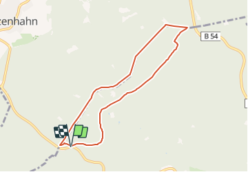
9 km | 11,8 km-effort
2h 40min
![](https://static1.geolcdn.com/siteimages/upload/files/16400158638029165_repeat_loop_refresh_sync_direction_icon.png)
Ja
![Tour Zu Fuß Bad Schwalbach - Nordic Walking Park 7 - Photo](https://media.geolcdn.com/t/375/260/ext.jpg?maxdim=2&url=https%3A%2F%2Fmedia.geolcdn.com%2Ff%2F64306b33-320a-4266-807e-3a311c77b146.jpeg)
![Zu Fuß Zu Fuß](https://static1.geolcdn.com/sitytour/trail-icons/100.png)
Nordic Walking Park 7
Zu Fuß
Einfach
Bad Schwalbach,
Hessen,
Rheingau-Taunus-Kreis,
Germany
![](/images/other/stat-length.png)
4,3 km | 5,4 km-effort
1h 13min
![](https://static1.geolcdn.com/siteimages/upload/files/16400158638029165_repeat_loop_refresh_sync_direction_icon.png)
Ja
![Tour Zu Fuß Bad Schwalbach - Nordic Walking Park 6 - Photo](https://media.geolcdn.com/t/375/260/ext.jpg?maxdim=2&url=https%3A%2F%2Fmedia.geolcdn.com%2Ff%2F64306b33-320a-4266-807e-3a311c77b146.jpeg)
![Zu Fuß Zu Fuß](https://static1.geolcdn.com/sitytour/trail-icons/100.png)
Nordic Walking Park 6
Zu Fuß
Einfach
Bad Schwalbach,
Hessen,
Rheingau-Taunus-Kreis,
Germany
![](/images/other/stat-length.png)
3,2 km | 4,2 km-effort
57min
![](https://static1.geolcdn.com/siteimages/upload/files/16400158638029165_repeat_loop_refresh_sync_direction_icon.png)
Ja
![Tour Zu Fuß Eltville am Rhein - Rheinsteig-Zuweg Niederwalluf (West) - Photo](https://media.geolcdn.com/t/375/260/ext.jpg?maxdim=2&url=https%3A%2F%2Fmedia.geolcdn.com%2Ff%2F37c3ad44-bffd-4d35-9f40-789cd2c4f541.jpeg)
![Zu Fuß Zu Fuß](https://static1.geolcdn.com/sitytour/trail-icons/100.png)
Rheinsteig-Zuweg Niederwalluf (West)
Zu Fuß
Einfach
Eltville am Rhein,
Hessen,
Rheingau-Taunus-Kreis,
Germany
![](/images/other/stat-length.png)
5,8 km | 8,2 km-effort
1h 51min
![](https://static1.geolcdn.com/siteimages/upload/files/16400158638029165_repeat_loop_refresh_sync_direction_icon.png)
Nein
![Tour Zu Fuß Taunusstein - Rundwanderweg Keiler - Photo](https://media.geolcdn.com/t/375/260/ext.jpg?maxdim=2&url=https%3A%2F%2Fmedia.geolcdn.com%2Ff%2Fd6de9aeb-45c5-4269-af11-16fff3b6e800.jpeg)
![Zu Fuß Zu Fuß](https://static1.geolcdn.com/sitytour/trail-icons/100.png)
Rundwanderweg Keiler
Zu Fuß
Einfach
Taunusstein,
Hessen,
Rheingau-Taunus-Kreis,
Germany
![](/images/other/stat-length.png)
4,7 km | 6 km-effort
1h 21min
![](https://static1.geolcdn.com/siteimages/upload/files/16400158638029165_repeat_loop_refresh_sync_direction_icon.png)
Nein
![Tour Zu Fuß Unbekannt - Rheinsteig-Zuweg Dotzheim - Photo](https://media.geolcdn.com/t/375/260/ext.jpg?maxdim=2&url=https%3A%2F%2Fmedia.geolcdn.com%2Ff%2F31beef47-d5a6-4c5c-b727-2ab898f7bcef.jpeg)
![Zu Fuß Zu Fuß](https://static1.geolcdn.com/sitytour/trail-icons/100.png)
Rheinsteig-Zuweg Dotzheim
Zu Fuß
Einfach
Unbekannt,
Hessen,
Wiesbaden,
Germany
![](/images/other/stat-length.png)
3,1 km | 4,1 km-effort
55min
![](https://static1.geolcdn.com/siteimages/upload/files/16400158638029165_repeat_loop_refresh_sync_direction_icon.png)
Nein
![Tour Zu Fuß Unbekannt - Rundwanderweg schwarze Flagge - Photo](https://media.geolcdn.com/t/375/260/ext.jpg?maxdim=2&url=https%3A%2F%2Fmedia.geolcdn.com%2Ff%2Ffa7b56ed-e4cf-4290-b555-85cce3a47808.jpeg)
![Zu Fuß Zu Fuß](https://static1.geolcdn.com/sitytour/trail-icons/100.png)
Rundwanderweg schwarze Flagge
Zu Fuß
Einfach
Unbekannt,
Hessen,
Wiesbaden,
Germany
![](/images/other/stat-length.png)
7,6 km | 10,7 km-effort
2h 25min
![](https://static1.geolcdn.com/siteimages/upload/files/16400158638029165_repeat_loop_refresh_sync_direction_icon.png)
Nein
![Tour Zu Fuß Taunusstein - Rundwanderweg rote Flagge - Photo](https://media.geolcdn.com/t/375/260/ext.jpg?maxdim=2&url=https%3A%2F%2Fmedia.geolcdn.com%2Ff%2Ffa7b56ed-e4cf-4290-b555-85cce3a47808.jpeg)
![Zu Fuß Zu Fuß](https://static1.geolcdn.com/sitytour/trail-icons/100.png)
Rundwanderweg rote Flagge
Zu Fuß
Einfach
Taunusstein,
Hessen,
Rheingau-Taunus-Kreis,
Germany
![](/images/other/stat-length.png)
4 km | 5,4 km-effort
1h 13min
![](https://static1.geolcdn.com/siteimages/upload/files/16400158638029165_repeat_loop_refresh_sync_direction_icon.png)
Ja
![Tour Zu Fuß Taunusstein - Rundwanderweg Geweih - Photo](https://media.geolcdn.com/t/375/260/ext.jpg?maxdim=2&url=https%3A%2F%2Fmedia.geolcdn.com%2Ff%2F95729a3c-d906-4c38-8925-a2081945e3f9.jpeg)
![Zu Fuß Zu Fuß](https://static1.geolcdn.com/sitytour/trail-icons/100.png)
Rundwanderweg Geweih
Zu Fuß
Einfach
Taunusstein,
Hessen,
Rheingau-Taunus-Kreis,
Germany
![](/images/other/stat-length.png)
3,3 km | 4,3 km-effort
58min
![](https://static1.geolcdn.com/siteimages/upload/files/16400158638029165_repeat_loop_refresh_sync_direction_icon.png)
Ja