![](/images/other/stat-length.png)
![Tour Zu Fuß Eschau - Kulturweg Eschau 1 - Photo](https://media.geolcdn.com/t/1900/400/6fc5bdcd-e31e-49fa-b74b-94b997ce55c8.jpeg&format=pjpeg&maxdim=2)
Kulturweg Eschau 1
SityTrail - itinéraires balisés pédestres
Tous les sentiers balisés d’Europe GUIDE+
![Länge](/images/other/stat-length.png)
Länge
3,9 km
![Maximale Höhe](https://static1.geolcdn.com/siteimages/upload/files/1508320355ic_sort_altitude_max_24dp.png)
Maximale Höhe
384 m
![Positive Höhendifferenz](https://static1.geolcdn.com/siteimages/upload/files/1508320355ic_sort_den_pos_24dp.png)
Positive Höhendifferenz
212 m
![Km-Effort](/images/other/stat-length.png)
Km-Effort
6,2 km
![Min. Höhe](https://static1.geolcdn.com/siteimages/upload/files/1508320355ic_sort_altitude_min_24dp.png)
Min. Höhe
171 m
![Negative Höhendifferenz](https://static1.geolcdn.com/siteimages/upload/files/1508320355ic_sort_den_neg_24dp.png)
Negative Höhendifferenz
51 m
![Boucle](https://static1.geolcdn.com/siteimages/upload/files/16400158638029165_repeat_loop_refresh_sync_direction_icon.png)
Boucle
Nein
Kennzeichnung
Erstellungsdatum :
2022-02-11 13:47:58.978
Letzte Änderung :
2022-02-11 13:47:58.978
![Zu Fuß](https://static1.geolcdn.com/sitytour/trail-icons/100.png)
1h24
Schwierigkeit : Einfach
![Scannen Sie diesen QR-Code, um die Tour in der SityTrail-Anwendung zu öffnen](https://capi.geolives.com/qq0zvz2zws4bq2lad0pu/sitytour/trails/3091231/qr.png?size=200)
Kostenlosegpshiking-Anwendung
Über SityTrail
Tour Zu Fuß von 3,9 km verfügbar auf Bayern, Landkreis Miltenberg, Eschau. Diese Tour wird von SityTrail - itinéraires balisés pédestres vorgeschlagen.
Beschreibung
Trail created by Archäologisches Spessartprojekt.
Symbol: Gelbes EU-Schiffchen auf blauem Grund
Website: https://www.spessartprojekt.de/?page_id=16117
Ort
Land:
Germany
Region :
Bayern
Abteilung/Provinz :
Landkreis Miltenberg
Kommune :
Eschau
Standort:
Unknown
Gehen Sie:(Dec)
Gehen Sie:(UTM)
518507 ; 5518668 (32U) N.
Kommentare
Touren in der Umgebung
![Tour Zu Fuß Eschau - Roter Hase Rundwanderweg Eschau - Photo](https://media.geolcdn.com/t/375/260/f18cf4e5-d28f-4d88-a667-aeffc283b576.jpeg&format=jpg&maxdim=2)
![Zu Fuß Zu Fuß](https://static1.geolcdn.com/sitytour/trail-icons/100.png)
Roter Hase Rundwanderweg Eschau
Zu Fuß
Einfach
Eschau,
Bayern,
Landkreis Miltenberg,
Germany
![](/images/other/stat-length.png)
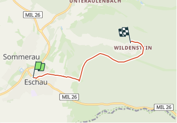
5,4 km | 6,9 km-effort
1h 34min
![](https://static1.geolcdn.com/siteimages/upload/files/16400158638029165_repeat_loop_refresh_sync_direction_icon.png)
Ja
![Tour Zu Fuß Eschau - Ortswanderweg Eschau 1 - Photo](https://media.geolcdn.com/t/375/260/fb3960ef-752d-41b4-b248-0264f2ac4a83.jpeg&format=jpg&maxdim=2)
![Zu Fuß Zu Fuß](https://static1.geolcdn.com/sitytour/trail-icons/100.png)
Ortswanderweg Eschau 1
Zu Fuß
Einfach
Eschau,
Bayern,
Landkreis Miltenberg,
Germany
![](/images/other/stat-length.png)
6,4 km | 7,9 km-effort
1h 48min
![](https://static1.geolcdn.com/siteimages/upload/files/16400158638029165_repeat_loop_refresh_sync_direction_icon.png)
Nein
![Tour Zu Fuß Dammbach - Roter Schmetterling, Rundwanderweg Geishöhe - Photo](https://media.geolcdn.com/t/375/260/39421771-6cea-45c1-a35b-2055701532fa.jpeg&format=jpg&maxdim=2)
![Zu Fuß Zu Fuß](https://static1.geolcdn.com/sitytour/trail-icons/100.png)
Roter Schmetterling, Rundwanderweg Geishöhe
Zu Fuß
Einfach
Dammbach,
Bayern,
Landkreis Aschaffenburg,
Germany
![](/images/other/stat-length.png)
3,5 km | 4,1 km-effort
56min
![](https://static1.geolcdn.com/siteimages/upload/files/16400158638029165_repeat_loop_refresh_sync_direction_icon.png)
Ja
![Tour Zu Fuß Kleinwallstadt - Ortswanderweg Kleinwallstadt 1 - Photo](https://media.geolcdn.com/t/375/260/cc806ef7-9a5f-4831-9099-5549e6ccc88b.jpeg&format=jpg&maxdim=2)
![Zu Fuß Zu Fuß](https://static1.geolcdn.com/sitytour/trail-icons/100.png)
Ortswanderweg Kleinwallstadt 1
Zu Fuß
Einfach
Kleinwallstadt,
Bayern,
Landkreis Miltenberg,
Germany
![](/images/other/stat-length.png)
4,3 km | 5 km-effort
1h 7min
![](https://static1.geolcdn.com/siteimages/upload/files/16400158638029165_repeat_loop_refresh_sync_direction_icon.png)
Nein
![Tour Zu Fuß Mönchberg - Nordic Walking Rot Sparkassen-Trail - Photo](https://media.geolcdn.com/t/375/260/c0662f05-e76e-434a-90ea-ced3a7f5af8d.jpeg&format=jpg&maxdim=2)
![Zu Fuß Zu Fuß](https://static1.geolcdn.com/sitytour/trail-icons/100.png)
Nordic Walking Rot Sparkassen-Trail
Zu Fuß
Einfach
Mönchberg,
Bayern,
Landkreis Miltenberg,
Germany
![](/images/other/stat-length.png)
10 km | 12,7 km-effort
2h 53min
![](https://static1.geolcdn.com/siteimages/upload/files/16400158638029165_repeat_loop_refresh_sync_direction_icon.png)
Nein
![Tour Zu Fuß Dammbach - Roter Hase, Rundwanderweg Dammbach - Photo](https://media.geolcdn.com/t/375/260/f9f8a02e-f420-404c-9db3-2d9a133dc96a.jpeg&format=jpg&maxdim=2)
![Zu Fuß Zu Fuß](https://static1.geolcdn.com/sitytour/trail-icons/100.png)
Roter Hase, Rundwanderweg Dammbach
Zu Fuß
Einfach
Dammbach,
Bayern,
Landkreis Aschaffenburg,
Germany
![](/images/other/stat-length.png)
6,4 km | 9,3 km-effort
2h 6min
![](https://static1.geolcdn.com/siteimages/upload/files/16400158638029165_repeat_loop_refresh_sync_direction_icon.png)
Ja
![Tour Zu Fuß Eschau - Schwarzer Keiler, Rundweg Eschau - Geishöhe - Photo](https://media.geolcdn.com/t/375/260/f18cf4e5-d28f-4d88-a667-aeffc283b576.jpeg&format=jpg&maxdim=2)
![Zu Fuß Zu Fuß](https://static1.geolcdn.com/sitytour/trail-icons/100.png)
Schwarzer Keiler, Rundweg Eschau - Geishöhe
Zu Fuß
Einfach
Eschau,
Bayern,
Landkreis Miltenberg,
Germany
![](/images/other/stat-length.png)
11,4 km | 16,3 km-effort
3h 42min
![](https://static1.geolcdn.com/siteimages/upload/files/16400158638029165_repeat_loop_refresh_sync_direction_icon.png)
Ja
![Tour Zu Fuß Kleinwallstadt - Kulturweg Weißer Leimen - Route Gelb - Photo](https://media.geolcdn.com/t/375/260/4692ef36-d1e3-42a6-a69c-861a7278d733.jpeg&format=jpg&maxdim=2)
![Zu Fuß Zu Fuß](https://static1.geolcdn.com/sitytour/trail-icons/100.png)
Kulturweg Weißer Leimen - Route Gelb
Zu Fuß
Einfach
Kleinwallstadt,
Bayern,
Landkreis Miltenberg,
Germany
![](/images/other/stat-length.png)
10,4 km | 14,8 km-effort
3h 22min
![](https://static1.geolcdn.com/siteimages/upload/files/16400158638029165_repeat_loop_refresh_sync_direction_icon.png)
Ja
![Tour Zu Fuß Eschau - Kulturweg Eschau 2 - Photo](https://media.geolcdn.com/t/375/260/ed3cf7af-7f5a-47f7-a6ed-79555311ba3d.jpeg&format=jpg&maxdim=2)
![Zu Fuß Zu Fuß](https://static1.geolcdn.com/sitytour/trail-icons/100.png)
Kulturweg Eschau 2
Zu Fuß
Einfach
Eschau,
Bayern,
Landkreis Miltenberg,
Germany
![](/images/other/stat-length.png)
7,2 km | 9,6 km-effort
2h 10min
![](https://static1.geolcdn.com/siteimages/upload/files/16400158638029165_repeat_loop_refresh_sync_direction_icon.png)
Ja