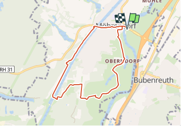
![](/images/other/stat-length.png)
![Tour Zu Fuß Möhrendorf - Wanderweg Südlicher Möhrendorfer Rundweg - Photo](https://media.geolcdn.com/t/1900/400/ea22ba3f-a9ef-4aa3-9503-4a65b8526407.jpeg&format=pjpeg&maxdim=2)
Wanderweg Südlicher Möhrendorfer Rundweg
SityTrail - itinéraires balisés pédestres
Tous les sentiers balisés d’Europe GUIDE+
![Länge](/images/other/stat-length.png)
Länge
7,4 km
![Maximale Höhe](https://static1.geolcdn.com/siteimages/upload/files/1508320355ic_sort_altitude_max_24dp.png)
Maximale Höhe
289 m
![Positive Höhendifferenz](https://static1.geolcdn.com/siteimages/upload/files/1508320355ic_sort_den_pos_24dp.png)
Positive Höhendifferenz
61 m
![Km-Effort](/images/other/stat-length.png)
Km-Effort
8,2 km
![Min. Höhe](https://static1.geolcdn.com/siteimages/upload/files/1508320355ic_sort_altitude_min_24dp.png)
Min. Höhe
263 m
![Negative Höhendifferenz](https://static1.geolcdn.com/siteimages/upload/files/1508320355ic_sort_den_neg_24dp.png)
Negative Höhendifferenz
61 m
![Boucle](https://static1.geolcdn.com/siteimages/upload/files/16400158638029165_repeat_loop_refresh_sync_direction_icon.png)
Boucle
Ja
Kennzeichnung
Erstellungsdatum :
2022-02-11 13:46:29.044
Letzte Änderung :
2022-02-11 13:46:29.044
![Zu Fuß](https://static1.geolcdn.com/sitytour/trail-icons/100.png)
1h52
Schwierigkeit : Einfach
![Scannen Sie diesen QR-Code, um die Tour in der SityTrail-Anwendung zu öffnen](https://capi.geolives.com/qq0zvz2zws4bq2lad0pu/sitytour/trails/3091156/qr.png?size=200)
Kostenlosegpshiking-Anwendung
Über SityTrail
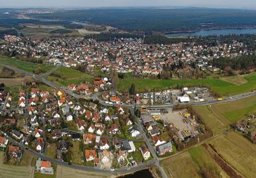
Tour Zu Fuß von 7,4 km verfügbar auf Bayern, Landkreis Erlangen-Höchstadt, Möhrendorf. Diese Tour wird von SityTrail - itinéraires balisés pédestres vorgeschlagen.
Beschreibung
Trail created by Agenda 21, Möhrendorf.
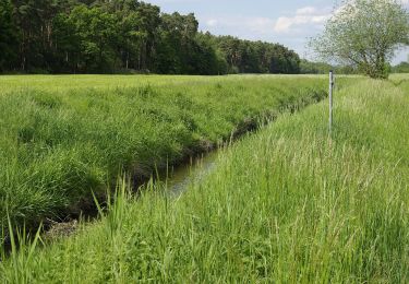
seit einiger Zeit mit weißem Wasserschöpfrad auf rotem Grund markiert
Symbol: weißes Wasserschöpfrad auf rotem Grund
Ort
Land:
Germany
Region :
Bayern
Abteilung/Provinz :
Landkreis Erlangen-Höchstadt
Kommune :
Möhrendorf
Standort:
Unknown
Gehen Sie:(Dec)
Gehen Sie:(UTM)
644793 ; 5500410 (32U) N.
Kommentare
Touren in der Umgebung
![Tour Zu Fuß - Erlangen-Steudach - Photo](https://media.geolcdn.com/t/375/260/326b0b59-d310-4208-b907-9fdb0ba2140b.jpeg&format=jpg&maxdim=2)
![Zu Fuß Zu Fuß](https://static1.geolcdn.com/sitytour/trail-icons/100.png)
![Tour Zu Fuß Baiersdorf - Meerrettichweg - Photo](https://media.geolcdn.com/t/375/260/92896cfd-f5cd-48c4-b2fd-c760b6de8ffd.jpeg&format=jpg&maxdim=2)
![Zu Fuß Zu Fuß](https://static1.geolcdn.com/sitytour/trail-icons/100.png)
Meerrettichweg
Zu Fuß
Einfach
Baiersdorf,
Bayern,
Landkreis Erlangen-Höchstadt,
Germany
![](/images/other/stat-length.png)
9,5 km | 10,8 km-effort
2h 27min
![](https://static1.geolcdn.com/siteimages/upload/files/16400158638029165_repeat_loop_refresh_sync_direction_icon.png)
Nein
![Tour Zu Fuß Bubenreuth - Hochwasserweg - Photo](https://media.geolcdn.com/t/375/260/0d4ced9c-0240-4646-a9bb-3ad2a492dab7.jpeg&format=jpg&maxdim=2)
![Zu Fuß Zu Fuß](https://static1.geolcdn.com/sitytour/trail-icons/100.png)
Hochwasserweg
Zu Fuß
Einfach
Bubenreuth,
Bayern,
Landkreis Erlangen-Höchstadt,
Germany
![](/images/other/stat-length.png)
7,6 km | 9,7 km-effort
2h 11min
![](https://static1.geolcdn.com/siteimages/upload/files/16400158638029165_repeat_loop_refresh_sync_direction_icon.png)
Ja
![Tour Zu Fuß Marloffstein - Berg & Talpfad - Photo](https://media.geolcdn.com/t/375/260/0d4ced9c-0240-4646-a9bb-3ad2a492dab7.jpeg&format=jpg&maxdim=2)
![Zu Fuß Zu Fuß](https://static1.geolcdn.com/sitytour/trail-icons/100.png)
Berg & Talpfad
Zu Fuß
Medium
Marloffstein,
Bayern,
Landkreis Erlangen-Höchstadt,
Germany
![](/images/other/stat-length.png)
17,4 km | 21 km-effort
4h 50min
![](https://static1.geolcdn.com/siteimages/upload/files/16400158638029165_repeat_loop_refresh_sync_direction_icon.png)
Ja
![Tour Zu Fuß Forchheim - Kersbach-Schlaifhausen - Photo](https://media.geolcdn.com/t/375/260/e4986558-fafa-48e1-b585-99a6745c78af.jpeg&format=jpg&maxdim=2)
![Zu Fuß Zu Fuß](https://static1.geolcdn.com/sitytour/trail-icons/100.png)
Kersbach-Schlaifhausen
Zu Fuß
Einfach
Forchheim,
Bayern,
Landkreis Forchheim,
Germany
![](/images/other/stat-length.png)
8,1 km | 10,8 km-effort
2h 27min
![](https://static1.geolcdn.com/siteimages/upload/files/16400158638029165_repeat_loop_refresh_sync_direction_icon.png)
Nein
![Tour Zu Fuß Möhrendorf - Wanderweg Nördlicher Möhrendorfer Rundweg - Photo](https://media.geolcdn.com/t/375/260/e180760a-0888-4e24-92e4-d287ef34491e.jpeg&format=jpg&maxdim=2)
![Zu Fuß Zu Fuß](https://static1.geolcdn.com/sitytour/trail-icons/100.png)
Wanderweg Nördlicher Möhrendorfer Rundweg
Zu Fuß
Einfach
Möhrendorf,
Bayern,
Landkreis Erlangen-Höchstadt,
Germany
![](/images/other/stat-length.png)
8,1 km | 9,7 km-effort
2h 12min
![](https://static1.geolcdn.com/siteimages/upload/files/16400158638029165_repeat_loop_refresh_sync_direction_icon.png)
Ja
![Tour Zu Fuß - DAK-Eisert-Nordic Walking Parcour - Photo](https://media.geolcdn.com/t/375/260/83bb39d6-d712-4c37-9cdf-22ccc440f885.jpeg&format=jpg&maxdim=2)
![Zu Fuß Zu Fuß](https://static1.geolcdn.com/sitytour/trail-icons/100.png)
DAK-Eisert-Nordic Walking Parcour
Zu Fuß
Einfach
,
Bayern,
Erlangen,
Germany
![](/images/other/stat-length.png)
10,9 km | 14,1 km-effort
3h 12min
![](https://static1.geolcdn.com/siteimages/upload/files/16400158638029165_repeat_loop_refresh_sync_direction_icon.png)
Ja
![Tour Zu Fuß - Erlangen 8 grün - Photo](https://media.geolcdn.com/t/375/260/4026b844-60dc-4d74-adfc-42edf5297bc2.jpeg&format=jpg&maxdim=2)
![Zu Fuß Zu Fuß](https://static1.geolcdn.com/sitytour/trail-icons/100.png)
![Tour Zu Fuß Mark - Wanderweg Erlangen 1 grün - Photo](https://media.geolcdn.com/t/375/260/ea22ba3f-a9ef-4aa3-9503-4a65b8526407.jpeg&format=jpg&maxdim=2)
![Zu Fuß Zu Fuß](https://static1.geolcdn.com/sitytour/trail-icons/100.png)
Wanderweg Erlangen 1 grün
Zu Fuß
Einfach
Mark,
Bayern,
Landkreis Erlangen-Höchstadt,
Germany
![](/images/other/stat-length.png)
16 km | 18,4 km-effort
4h 11min
![](https://static1.geolcdn.com/siteimages/upload/files/16400158638029165_repeat_loop_refresh_sync_direction_icon.png)
Ja