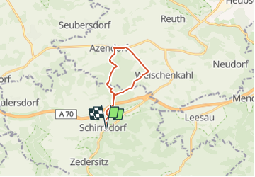
![](/images/other/stat-length.png)
![Tour Zu Fuß Wonsees - Schirradorf Rundwanderweg 1 - Photo](https://media.geolcdn.com/t/1900/400/fb84a498-b9cc-4b31-bf83-4221315a1267.jpeg&format=pjpeg&maxdim=2)
Schirradorf Rundwanderweg 1
SityTrail - itinéraires balisés pédestres
Tous les sentiers balisés d’Europe GUIDE+
![Länge](/images/other/stat-length.png)
![Maximale Höhe](https://static1.geolcdn.com/siteimages/upload/files/1508320355ic_sort_altitude_max_24dp.png)
![Positive Höhendifferenz](https://static1.geolcdn.com/siteimages/upload/files/1508320355ic_sort_den_pos_24dp.png)
![Km-Effort](/images/other/stat-length.png)
![Min. Höhe](https://static1.geolcdn.com/siteimages/upload/files/1508320355ic_sort_altitude_min_24dp.png)
![Negative Höhendifferenz](https://static1.geolcdn.com/siteimages/upload/files/1508320355ic_sort_den_neg_24dp.png)
![Boucle](https://static1.geolcdn.com/siteimages/upload/files/16400158638029165_repeat_loop_refresh_sync_direction_icon.png)
![Zu Fuß](https://static1.geolcdn.com/sitytour/trail-icons/100.png)
2h12
Schwierigkeit : Einfach
![Scannen Sie diesen QR-Code, um die Tour in der SityTrail-Anwendung zu öffnen](https://capi.geolives.com/qq0zvz2zws4bq2lad0pu/sitytour/trails/3090793/qr.png?size=200)
Kostenlosegpshiking-Anwendung
Über SityTrail
Tour Zu Fuß von 7,9 km verfügbar auf Bayern, Landkreis Kulmbach, Wonsees. Diese Tour wird von SityTrail - itinéraires balisés pédestres vorgeschlagen.
Beschreibung
Trail created by Landkreis Lichtenfels.
Markierung sehr unvollständig, auch schwarze 1 auf weißem Hintergrund
Symbol: Schwarze 1 zwischen zwei Punkten auf weißem Hintergrund
Ort
Kommentare
Touren in der Umgebung
![Tour Zu Fuß Kasendorf - Rundweg Roter Ring Thurnau - Photo](https://media.geolcdn.com/t/375/260/bcecfbe5-6717-41bc-b57e-077bc6802b47.jpeg&format=jpg&maxdim=2)
![Zu Fuß Zu Fuß](https://static1.geolcdn.com/sitytour/trail-icons/100.png)
Zu Fuß
![](/images/other/stat-length.png)
![](https://static1.geolcdn.com/siteimages/upload/files/16400158638029165_repeat_loop_refresh_sync_direction_icon.png)
![Tour Zu Fuß Wonsees - Rundwanderweg blauer Ring - Photo](https://media.geolcdn.com/t/375/260/be4429f4-4295-4ae3-bd5f-a675ea71e1d9.jpeg&format=jpg&maxdim=2)
![Zu Fuß Zu Fuß](https://static1.geolcdn.com/sitytour/trail-icons/100.png)
Zu Fuß
![](/images/other/stat-length.png)
![](https://static1.geolcdn.com/siteimages/upload/files/16400158638029165_repeat_loop_refresh_sync_direction_icon.png)
![Tour Zu Fuß Wonsees - Wonsees Rundwanderweg roter Ring - Photo](https://media.geolcdn.com/t/375/260/d406bcc3-a10c-46ac-9d22-900ef624702c.jpeg&format=jpg&maxdim=2)
![Zu Fuß Zu Fuß](https://static1.geolcdn.com/sitytour/trail-icons/100.png)
Zu Fuß
![](/images/other/stat-length.png)
![](https://static1.geolcdn.com/siteimages/upload/files/16400158638029165_repeat_loop_refresh_sync_direction_icon.png)
![Tour Zu Fuß Wonsees - Wacholderweg Wonsees - Photo](https://media.geolcdn.com/t/375/260/22a22661-ea8f-43f2-9035-b9f41ee36c86.jpeg&format=jpg&maxdim=2)
![Zu Fuß Zu Fuß](https://static1.geolcdn.com/sitytour/trail-icons/100.png)
Zu Fuß
![](/images/other/stat-length.png)
![](https://static1.geolcdn.com/siteimages/upload/files/16400158638029165_repeat_loop_refresh_sync_direction_icon.png)
![Tour Zu Fuß Wonsees - Schirradorf Rundwanderweg 4 - Photo](https://media.geolcdn.com/t/375/260/7313764d-ae4a-464f-b457-1cc80e419261.jpeg&format=jpg&maxdim=2)
![Zu Fuß Zu Fuß](https://static1.geolcdn.com/sitytour/trail-icons/100.png)
Zu Fuß
![](/images/other/stat-length.png)
![](https://static1.geolcdn.com/siteimages/upload/files/16400158638029165_repeat_loop_refresh_sync_direction_icon.png)
![Tour Zu Fuß Hollfeld - Von Burg zu Burg - Photo](https://media.geolcdn.com/t/375/260/b8dfbade-9986-48d0-b2b5-4128ccc147c5.jpeg&format=jpg&maxdim=2)
![Zu Fuß Zu Fuß](https://static1.geolcdn.com/sitytour/trail-icons/100.png)
Zu Fuß
![](/images/other/stat-length.png)
![](https://static1.geolcdn.com/siteimages/upload/files/16400158638029165_repeat_loop_refresh_sync_direction_icon.png)
![Tour Zu Fuß Weismain - Kasendorf Rundweg Schwarzer Ring - Photo](https://media.geolcdn.com/t/375/260/e41fe585-4567-4410-8104-1fc901a53465.jpeg&format=jpg&maxdim=2)
![Zu Fuß Zu Fuß](https://static1.geolcdn.com/sitytour/trail-icons/100.png)
Zu Fuß
![](/images/other/stat-length.png)
![](https://static1.geolcdn.com/siteimages/upload/files/16400158638029165_repeat_loop_refresh_sync_direction_icon.png)
![Tour Zu Fuß Wonsees - Rundwanderweg gelber Ring - Photo](https://media.geolcdn.com/t/375/260/7313764d-ae4a-464f-b457-1cc80e419261.jpeg&format=jpg&maxdim=2)
![Zu Fuß Zu Fuß](https://static1.geolcdn.com/sitytour/trail-icons/100.png)
Zu Fuß
![](/images/other/stat-length.png)
![](https://static1.geolcdn.com/siteimages/upload/files/16400158638029165_repeat_loop_refresh_sync_direction_icon.png)
![Tour Zu Fuß Wonsees - Schirradorf Rundwanderweg 3 - Photo](https://media.geolcdn.com/t/375/260/7313764d-ae4a-464f-b457-1cc80e419261.jpeg&format=jpg&maxdim=2)
![Zu Fuß Zu Fuß](https://static1.geolcdn.com/sitytour/trail-icons/100.png)
Zu Fuß
![](/images/other/stat-length.png)
![](https://static1.geolcdn.com/siteimages/upload/files/16400158638029165_repeat_loop_refresh_sync_direction_icon.png)