


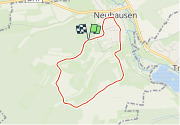

5,7 km | 6,9 km-effort

Tous les sentiers balisés d’Europe GUIDE+


Kostenlosegpshiking-Anwendung
 SityTrail
IGN / Geografische Institute
SityTrail World
Die Welt öffnet sich für Sie
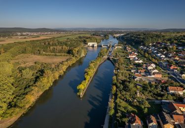
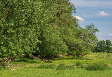
Tour Zu Fuß von 3,2 km verfügbar auf Bayern, Landkreis Bamberg, Priesendorf. Diese Tour wird von SityTrail - itinéraires balisés pédestres vorgeschlagen.
Trail created by Gemeinde Priesendorf.
Symbol: schwarze P 2 auf gelbem Grund
 "
data-pinterest-text="Pin it"
data-tweet-text="share on twitter"
data-facebook-share-url="https://www.sitytrail.com/de/trails/3090781-priesendorf--rundweg-priesendorf-p-2-xchristbaumwegx/?photo=1#lg=1&slide=1"
data-twitter-share-url="https://www.sitytrail.com/de/trails/3090781-priesendorf--rundweg-priesendorf-p-2-xchristbaumwegx/?photo=1#lg=1&slide=1"
data-googleplus-share-url="https://www.sitytrail.com/de/trails/3090781-priesendorf--rundweg-priesendorf-p-2-xchristbaumwegx/?photo=1#lg=1&slide=1"
data-pinterest-share-url="https://www.sitytrail.com/de/trails/3090781-priesendorf--rundweg-priesendorf-p-2-xchristbaumwegx/?photo=1#lg=1&slide=1">
"
data-pinterest-text="Pin it"
data-tweet-text="share on twitter"
data-facebook-share-url="https://www.sitytrail.com/de/trails/3090781-priesendorf--rundweg-priesendorf-p-2-xchristbaumwegx/?photo=1#lg=1&slide=1"
data-twitter-share-url="https://www.sitytrail.com/de/trails/3090781-priesendorf--rundweg-priesendorf-p-2-xchristbaumwegx/?photo=1#lg=1&slide=1"
data-googleplus-share-url="https://www.sitytrail.com/de/trails/3090781-priesendorf--rundweg-priesendorf-p-2-xchristbaumwegx/?photo=1#lg=1&slide=1"
data-pinterest-share-url="https://www.sitytrail.com/de/trails/3090781-priesendorf--rundweg-priesendorf-p-2-xchristbaumwegx/?photo=1#lg=1&slide=1">
 "
data-pinterest-text="Pin it"
data-tweet-text="share on twitter"
data-facebook-share-url="https://www.sitytrail.com/de/trails/3090781-priesendorf--rundweg-priesendorf-p-2-xchristbaumwegx/?photo=2#lg=1&slide=2"
data-twitter-share-url="https://www.sitytrail.com/de/trails/3090781-priesendorf--rundweg-priesendorf-p-2-xchristbaumwegx/?photo=2#lg=1&slide=2"
data-googleplus-share-url="https://www.sitytrail.com/de/trails/3090781-priesendorf--rundweg-priesendorf-p-2-xchristbaumwegx/?photo=2#lg=1&slide=2"
data-pinterest-share-url="https://www.sitytrail.com/de/trails/3090781-priesendorf--rundweg-priesendorf-p-2-xchristbaumwegx/?photo=2#lg=1&slide=2">
"
data-pinterest-text="Pin it"
data-tweet-text="share on twitter"
data-facebook-share-url="https://www.sitytrail.com/de/trails/3090781-priesendorf--rundweg-priesendorf-p-2-xchristbaumwegx/?photo=2#lg=1&slide=2"
data-twitter-share-url="https://www.sitytrail.com/de/trails/3090781-priesendorf--rundweg-priesendorf-p-2-xchristbaumwegx/?photo=2#lg=1&slide=2"
data-googleplus-share-url="https://www.sitytrail.com/de/trails/3090781-priesendorf--rundweg-priesendorf-p-2-xchristbaumwegx/?photo=2#lg=1&slide=2"
data-pinterest-share-url="https://www.sitytrail.com/de/trails/3090781-priesendorf--rundweg-priesendorf-p-2-xchristbaumwegx/?photo=2#lg=1&slide=2">
 "
data-pinterest-text="Pin it"
data-tweet-text="share on twitter"
data-facebook-share-url="https://www.sitytrail.com/de/trails/3090781-priesendorf--rundweg-priesendorf-p-2-xchristbaumwegx/?photo=3#lg=1&slide=3"
data-twitter-share-url="https://www.sitytrail.com/de/trails/3090781-priesendorf--rundweg-priesendorf-p-2-xchristbaumwegx/?photo=3#lg=1&slide=3"
data-googleplus-share-url="https://www.sitytrail.com/de/trails/3090781-priesendorf--rundweg-priesendorf-p-2-xchristbaumwegx/?photo=3#lg=1&slide=3"
data-pinterest-share-url="https://www.sitytrail.com/de/trails/3090781-priesendorf--rundweg-priesendorf-p-2-xchristbaumwegx/?photo=3#lg=1&slide=3">
"
data-pinterest-text="Pin it"
data-tweet-text="share on twitter"
data-facebook-share-url="https://www.sitytrail.com/de/trails/3090781-priesendorf--rundweg-priesendorf-p-2-xchristbaumwegx/?photo=3#lg=1&slide=3"
data-twitter-share-url="https://www.sitytrail.com/de/trails/3090781-priesendorf--rundweg-priesendorf-p-2-xchristbaumwegx/?photo=3#lg=1&slide=3"
data-googleplus-share-url="https://www.sitytrail.com/de/trails/3090781-priesendorf--rundweg-priesendorf-p-2-xchristbaumwegx/?photo=3#lg=1&slide=3"
data-pinterest-share-url="https://www.sitytrail.com/de/trails/3090781-priesendorf--rundweg-priesendorf-p-2-xchristbaumwegx/?photo=3#lg=1&slide=3">


Zu Fuß

Zu Fuß

Zu Fuß

Zu Fuß
Zu Fuß
Zu Fuß
Zu Fuß
Zu Fuß
Zu Fuß