![](/images/other/stat-length.png)
![Tour Zu Fuß Laubach - Wetterweg - Photo](https://media.geolcdn.com/t/1900/400/2100a7e7-50ec-49f5-a2a2-5fae1b4dcbe5.jpeg&format=pjpeg&maxdim=2)
Wetterweg
SityTrail - itinéraires balisés pédestres
Tous les sentiers balisés d’Europe GUIDE+
![Länge](/images/other/stat-length.png)
Länge
31 km
![Maximale Höhe](https://static1.geolcdn.com/siteimages/upload/files/1508320355ic_sort_altitude_max_24dp.png)
Maximale Höhe
245 m
![Positive Höhendifferenz](https://static1.geolcdn.com/siteimages/upload/files/1508320355ic_sort_den_pos_24dp.png)
Positive Höhendifferenz
393 m
![Km-Effort](/images/other/stat-length.png)
Km-Effort
37 km
![Min. Höhe](https://static1.geolcdn.com/siteimages/upload/files/1508320355ic_sort_altitude_min_24dp.png)
Min. Höhe
162 m
![Negative Höhendifferenz](https://static1.geolcdn.com/siteimages/upload/files/1508320355ic_sort_den_neg_24dp.png)
Negative Höhendifferenz
438 m
![Boucle](https://static1.geolcdn.com/siteimages/upload/files/16400158638029165_repeat_loop_refresh_sync_direction_icon.png)
Boucle
Nein
Kennzeichnung
Erstellungsdatum :
2022-02-11 13:29:04.488
Letzte Änderung :
2022-02-11 13:29:04.488
![Zu Fuß](https://static1.geolcdn.com/sitytour/trail-icons/100.png)
8h19
Schwierigkeit : Schwierig
![Scannen Sie diesen QR-Code, um die Tour in der SityTrail-Anwendung zu öffnen](https://capi.geolives.com/qq0zvz2zws4bq2lad0pu/sitytour/trails/3090447/qr.png?size=200)
Kostenlosegpshiking-Anwendung
Über SityTrail
Tour Zu Fuß von 31 km verfügbar auf Hessen, Landkreis Gießen, Laubach. Diese Tour wird von SityTrail - itinéraires balisés pédestres vorgeschlagen.
Beschreibung
Trail created by Vogelsberger Höhenclub.
complete (Markierungswanderung VHC 09-2011)
Symbol: rotes W und 2 Wellen auf gelben Grund
Ort
Land:
Germany
Region :
Hessen
Abteilung/Provinz :
Landkreis Gießen
Kommune :
Laubach
Standort:
Unknown
Gehen Sie:(Dec)
Gehen Sie:(UTM)
500455 ; 5598246 (32U) N.
Kommentare
Touren in der Umgebung
![Tour Zu Fuß Schotten - Rundwanderweg Einartshausen E1 - Photo](https://media.geolcdn.com/t/375/260/1a30cdf5-be1f-4e2e-a426-3cc85314c985.jpeg&format=jpg&maxdim=2)
![Zu Fuß Zu Fuß](https://static1.geolcdn.com/sitytour/trail-icons/100.png)
Rundwanderweg Einartshausen E1
Zu Fuß
Medium
Schotten,
Hessen,
Vogelsbergkreis,
Germany
![](/images/other/stat-length.png)
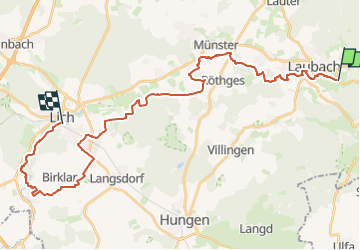
15,6 km | 20 km-effort
4h 38min
![](https://static1.geolcdn.com/siteimages/upload/files/16400158638029165_repeat_loop_refresh_sync_direction_icon.png)
Ja
![Tour Zu Fuß Laubach - Laubach Panoramaweg - Photo](https://media.geolcdn.com/t/375/260/e34012cc-d8aa-4f6c-9a87-671f68d3e4a4.jpeg&format=jpg&maxdim=2)
![Zu Fuß Zu Fuß](https://static1.geolcdn.com/sitytour/trail-icons/100.png)
Laubach Panoramaweg
Zu Fuß
Einfach
Laubach,
Hessen,
Landkreis Gießen,
Germany
![](/images/other/stat-length.png)
8,9 km | 11,3 km-effort
2h 34min
![](https://static1.geolcdn.com/siteimages/upload/files/16400158638029165_repeat_loop_refresh_sync_direction_icon.png)
Ja
![Tour Zu Fuß Laubach - Rundweg Laubach - Photo](https://media.geolcdn.com/t/375/260/bffec006-1ed4-4d5e-92eb-b1080eb29654.jpeg&format=jpg&maxdim=2)
![Zu Fuß Zu Fuß](https://static1.geolcdn.com/sitytour/trail-icons/100.png)
Rundweg Laubach
Zu Fuß
Sehr schwierig
Laubach,
Hessen,
Landkreis Gießen,
Germany
![](/images/other/stat-length.png)
35 km | 46 km-effort
10h 22min
![](https://static1.geolcdn.com/siteimages/upload/files/16400158638029165_repeat_loop_refresh_sync_direction_icon.png)
Ja
![Tour Zu Fuß Laubach - Laubach Steinbachweg - Photo](https://media.geolcdn.com/t/375/260/ext.jpg?maxdim=2&url=https%3A%2F%2Fstatic1.geolcdn.com%2Fsiteimages%2Fupload%2Ffiles%2F1545311037marcheuse_200dpi.jpg)
![Zu Fuß Zu Fuß](https://static1.geolcdn.com/sitytour/trail-icons/100.png)
Laubach Steinbachweg
Zu Fuß
Einfach
Laubach,
Hessen,
Landkreis Gießen,
Germany
![](/images/other/stat-length.png)
3,5 km | 4,5 km-effort
1h 1min
![](https://static1.geolcdn.com/siteimages/upload/files/16400158638029165_repeat_loop_refresh_sync_direction_icon.png)
Ja
![Tour Zu Fuß Laubach - Laubach Ramsbergrundweg - Photo](https://media.geolcdn.com/t/375/260/ext.jpg?maxdim=2&url=https%3A%2F%2Fstatic1.geolcdn.com%2Fsiteimages%2Fupload%2Ffiles%2F1545311037marcheuse_200dpi.jpg)
![Zu Fuß Zu Fuß](https://static1.geolcdn.com/sitytour/trail-icons/100.png)
Laubach Ramsbergrundweg
Zu Fuß
Einfach
Laubach,
Hessen,
Landkreis Gießen,
Germany
![](/images/other/stat-length.png)
3,2 km | 4 km-effort
54min
![](https://static1.geolcdn.com/siteimages/upload/files/16400158638029165_repeat_loop_refresh_sync_direction_icon.png)
Ja
![Tour Zu Fuß Laubach - Laubach - Nordic 3 Engelsburg - Photo](https://media.geolcdn.com/t/375/260/ext.jpg?maxdim=2&url=https%3A%2F%2Fstatic1.geolcdn.com%2Fsiteimages%2Fupload%2Ffiles%2F1545311037marcheuse_200dpi.jpg)
![Zu Fuß Zu Fuß](https://static1.geolcdn.com/sitytour/trail-icons/100.png)
Laubach - Nordic 3 Engelsburg
Zu Fuß
Einfach
Laubach,
Hessen,
Landkreis Gießen,
Germany
![](/images/other/stat-length.png)
7,9 km | 10,7 km-effort
2h 26min
![](https://static1.geolcdn.com/siteimages/upload/files/16400158638029165_repeat_loop_refresh_sync_direction_icon.png)
Nein
![Tour Zu Fuß Laubach - Laubach - Nordic 2 Hahnkopf - Photo](https://media.geolcdn.com/t/375/260/ext.jpg?maxdim=2&url=https%3A%2F%2Fstatic1.geolcdn.com%2Fsiteimages%2Fupload%2Ffiles%2F1545311037marcheuse_200dpi.jpg)
![Zu Fuß Zu Fuß](https://static1.geolcdn.com/sitytour/trail-icons/100.png)
Laubach - Nordic 2 Hahnkopf
Zu Fuß
Einfach
Laubach,
Hessen,
Landkreis Gießen,
Germany
![](/images/other/stat-length.png)
4,9 km | 6,6 km-effort
1h 30min
![](https://static1.geolcdn.com/siteimages/upload/files/16400158638029165_repeat_loop_refresh_sync_direction_icon.png)
Nein
![Tour Zu Fuß Laubach - Laubach - Nordic 7 Drei Mühlen - Photo](https://media.geolcdn.com/t/375/260/ext.jpg?maxdim=2&url=https%3A%2F%2Fstatic1.geolcdn.com%2Fsiteimages%2Fupload%2Ffiles%2F1545311037marcheuse_200dpi.jpg)
![Zu Fuß Zu Fuß](https://static1.geolcdn.com/sitytour/trail-icons/100.png)
Laubach - Nordic 7 Drei Mühlen
Zu Fuß
Einfach
Laubach,
Hessen,
Landkreis Gießen,
Germany
![](/images/other/stat-length.png)
14,7 km | 18,7 km-effort
4h 14min
![](https://static1.geolcdn.com/siteimages/upload/files/16400158638029165_repeat_loop_refresh_sync_direction_icon.png)
Ja
![Tour Zu Fuß Laubach - Laubach - Nordic 4 Gaulskopf - Photo](https://media.geolcdn.com/t/375/260/ext.jpg?maxdim=2&url=https%3A%2F%2Fstatic1.geolcdn.com%2Fsiteimages%2Fupload%2Ffiles%2F1545311037marcheuse_200dpi.jpg)
![Zu Fuß Zu Fuß](https://static1.geolcdn.com/sitytour/trail-icons/100.png)
Laubach - Nordic 4 Gaulskopf
Zu Fuß
Einfach
Laubach,
Hessen,
Landkreis Gießen,
Germany
![](/images/other/stat-length.png)
4,5 km | 5,6 km-effort
1h 16min
![](https://static1.geolcdn.com/siteimages/upload/files/16400158638029165_repeat_loop_refresh_sync_direction_icon.png)
Ja