![](/images/other/stat-length.png)
![Tour Laufen Lierneux - Jogging des 3 Sarts 5km - Photo](https://media.geolcdn.com/t/1900/400/ext.pjpeg?maxdim=2&url=https%3A%2F%2Fstatic1.geolcdn.com%2Fsiteimages%2Fupload%2Ffiles%2F1524743154running.jpg)
Jogging des 3 Sarts 5km
Nico222
Benutzer
![Länge](/images/other/stat-length.png)
Länge
5,9 km
![Maximale Höhe](https://static1.geolcdn.com/siteimages/upload/files/1508320355ic_sort_altitude_max_24dp.png)
Maximale Höhe
506 m
![Positive Höhendifferenz](https://static1.geolcdn.com/siteimages/upload/files/1508320355ic_sort_den_pos_24dp.png)
Positive Höhendifferenz
94 m
![Km-Effort](/images/other/stat-length.png)
Km-Effort
7,2 km
![Min. Höhe](https://static1.geolcdn.com/siteimages/upload/files/1508320355ic_sort_altitude_min_24dp.png)
Min. Höhe
424 m
![Negative Höhendifferenz](https://static1.geolcdn.com/siteimages/upload/files/1508320355ic_sort_den_neg_24dp.png)
Negative Höhendifferenz
97 m
![Boucle](https://static1.geolcdn.com/siteimages/upload/files/16400158638029165_repeat_loop_refresh_sync_direction_icon.png)
Boucle
Ja
Erstellungsdatum :
2014-12-10 00:00:00.0
Letzte Änderung :
2014-12-10 00:00:00.0
![Laufen](https://static1.geolcdn.com/sitytour/trail-icons/103.png)
--
Schwierigkeit : Einfach
![Scannen Sie diesen QR-Code, um die Tour in der SityTrail-Anwendung zu öffnen](https://capi.geolives.com/qq0zvz2zws4bq2lad0pu/sitytour/trails/309034/qr.png?size=200)
Kostenlosegpshiking-Anwendung
Über SityTrail
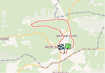
Tour Laufen von 5,9 km verfügbar auf Wallonien, Lüttich, Lierneux. Diese Tour wird von Nico222 vorgeschlagen.
Beschreibung
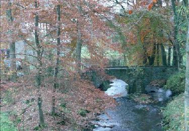
parcours officiel de la petite distance du jogging des 3 Sarts, manche du challenge de la Salm. Départ du terrain de football.Plus d'infos sur www.challengedelasalm.net
Ort
Land:
Belgium
Region :
Wallonien
Abteilung/Provinz :
Lüttich
Kommune :
Lierneux
Standort:
Lierneux
Gehen Sie:(Dec)
Gehen Sie:(UTM)
703146 ; 5572208 (31U) N.
Kommentare
Touren in der Umgebung
![Tour Wandern Lierneux - RB-LG-16 - Une promenade « aérienne » dans la vallée de la Lienne - Photo](https://media.geolcdn.com/t/375/260/ext.jpg?maxdim=2&url=https%3A%2F%2Fstatic1.geolcdn.com%2Fsiteimages%2Fupload%2Ffiles%2F1553511878bg_sport_marche.png)
![Wandern Wandern](https://static1.geolcdn.com/sitytour/trail-icons/101.png)
RB-LG-16 - Une promenade « aérienne » dans la vallée de la Lienne
Wandern
Medium
(6)
Lierneux,
Wallonien,
Lüttich,
Belgium
![](/images/other/stat-length.png)
19,5 km | 25 km-effort
5h 16min
![](https://static1.geolcdn.com/siteimages/upload/files/16400158638029165_repeat_loop_refresh_sync_direction_icon.png)
Ja
![Tour Wandern Vielsalm - 2023-04-02_15h38m24_Cirkwi-Vielsalm___Pays_du_bois,_de_la_pierre_de_l_eau - Photo](https://media.geolcdn.com/t/375/260/0c677089-4c6a-401e-ab95-09fc62ad11cf.jpg&format=jpg&maxdim=2)
![Wandern Wandern](https://static1.geolcdn.com/sitytour/trail-icons/101.png)
2023-04-02_15h38m24_Cirkwi-Vielsalm___Pays_du_bois,_de_la_pierre_de_l_eau
Wandern
Medium
(2)
Vielsalm,
Wallonien,
Luxemburg,
Belgium
![](/images/other/stat-length.png)
11,6 km | 15,6 km-effort
3h 32min
![](https://static1.geolcdn.com/siteimages/upload/files/16400158638029165_repeat_loop_refresh_sync_direction_icon.png)
Ja
![Tour Wandern Vielsalm - GG-Lu-16_Vielsalm - Gouvy - Photo](https://media.geolcdn.com/t/375/260/8dcabdae-2ff1-4908-b3bb-b5309e97313c.jpg&format=jpg&maxdim=2)
![Wandern Wandern](https://static1.geolcdn.com/sitytour/trail-icons/101.png)
GG-Lu-16_Vielsalm - Gouvy
Wandern
Sehr schwierig
(3)
Vielsalm,
Wallonien,
Luxemburg,
Belgium
![](/images/other/stat-length.png)
16 km | 22 km-effort
4h 48min
![](https://static1.geolcdn.com/siteimages/upload/files/16400158638029165_repeat_loop_refresh_sync_direction_icon.png)
Nein
![Tour Wandern Lierneux - RB-Lg-25_Arbrefontaine_via-racc-2 - Photo](https://media.geolcdn.com/t/375/260/ext.jpg?maxdim=2&url=https%3A%2F%2Fservices.sitytrail.com%2FGeolivesWS%2FDownloadMedia.ashx%3FTrailID%3D400946%26Media%3Dfe3505cb-bdd0-409b-9697-390f9300195f.jpg)
![Wandern Wandern](https://static1.geolcdn.com/sitytour/trail-icons/101.png)
RB-Lg-25_Arbrefontaine_via-racc-2
Wandern
(3)
Lierneux,
Wallonien,
Lüttich,
Belgium
![](/images/other/stat-length.png)
17,7 km | 23 km-effort
5h 12min
![](https://static1.geolcdn.com/siteimages/upload/files/16400158638029165_repeat_loop_refresh_sync_direction_icon.png)
Ja
![Tour Wandern Lierneux - RB-Lg-25_Arbrefontaine - Photo](https://media.geolcdn.com/t/375/260/ext.jpg?maxdim=2&url=https%3A%2F%2Fservices.sitytrail.com%2FGeolivesWS%2FDownloadMedia.ashx%3FTrailID%3D400945%26Media%3Dfe3505cb-bdd0-409b-9697-390f9300195f.jpg)
![Wandern Wandern](https://static1.geolcdn.com/sitytour/trail-icons/101.png)
RB-Lg-25_Arbrefontaine
Wandern
(4)
Lierneux,
Wallonien,
Lüttich,
Belgium
![](/images/other/stat-length.png)
25 km | 33 km-effort
7h 25min
![](https://static1.geolcdn.com/siteimages/upload/files/16400158638029165_repeat_loop_refresh_sync_direction_icon.png)
Ja
![Tour Wandern Vielsalm - RB-LUX-03 - Raccourci - Dans les vallées de la Salm et du Glain - Photo](https://media.geolcdn.com/t/375/260/ext.jpg?maxdim=2&url=https%3A%2F%2Fservices.sitytrail.com%2FGeolivesWS%2FDownloadMedia.ashx%3FTrailID%3D216051%26Media%3D51a8d94d-ce85-4f46-8793-517bb65c5b20.jpg)
![Wandern Wandern](https://static1.geolcdn.com/sitytour/trail-icons/101.png)
RB-LUX-03 - Raccourci - Dans les vallées de la Salm et du Glain
Wandern
Einfach
(4)
Vielsalm,
Wallonien,
Luxemburg,
Belgium
![](/images/other/stat-length.png)
16,8 km | 23 km-effort
3h 36min
![](https://static1.geolcdn.com/siteimages/upload/files/16400158638029165_repeat_loop_refresh_sync_direction_icon.png)
Ja
![Tour Wandern Vielsalm - RB-LUX-03 - Dans les vallées de la Salm et du Glain - Photo](https://media.geolcdn.com/t/375/260/ext.jpg?maxdim=2&url=https%3A%2F%2Fservices.sitytrail.com%2FGeolivesWS%2FDownloadMedia.ashx%3FTrailID%3D179612%26Media%3Db9c1cda3-4257-4d22-9a9f-65f69e9d8092.jpg)
![Wandern Wandern](https://static1.geolcdn.com/sitytour/trail-icons/101.png)
RB-LUX-03 - Dans les vallées de la Salm et du Glain
Wandern
Medium
(4)
Vielsalm,
Wallonien,
Luxemburg,
Belgium
![](/images/other/stat-length.png)
22 km | 30 km-effort
6h 10min
![](https://static1.geolcdn.com/siteimages/upload/files/16400158638029165_repeat_loop_refresh_sync_direction_icon.png)
Ja
![Tour Wandern Geilich - 15 juli 2012 - Photo](https://media.geolcdn.com/t/375/260/ext.jpg?maxdim=2&url=https%3A%2F%2Fservices.sitytrail.com%2FGeolivesWS%2FDownloadMedia.ashx%3FTrailID%3D139158%26Media%3D20120715121313.jpg)
![Wandern Wandern](https://static1.geolcdn.com/sitytour/trail-icons/101.png)
15 juli 2012
Wandern
Sehr leicht
(1)
Geilich,
Wallonien,
Luxemburg,
Belgium
![](/images/other/stat-length.png)
5,1 km | 6,1 km-effort
1h 53min
![](https://static1.geolcdn.com/siteimages/upload/files/16400158638029165_repeat_loop_refresh_sync_direction_icon.png)
Ja
![Tour Wandern Lierneux - RB-LG-16 - Raccourci - Photo](https://media.geolcdn.com/t/375/260/ext.jpg?maxdim=2&url=https%3A%2F%2Fstatic1.geolcdn.com%2Fsiteimages%2Fupload%2Ffiles%2F1553511878bg_sport_marche.png)
![Wandern Wandern](https://static1.geolcdn.com/sitytour/trail-icons/101.png)
RB-LG-16 - Raccourci
Wandern
Schwierig
(2)
Lierneux,
Wallonien,
Lüttich,
Belgium
![](/images/other/stat-length.png)
13,5 km | 17,5 km-effort
3h 58min
![](https://static1.geolcdn.com/siteimages/upload/files/16400158638029165_repeat_loop_refresh_sync_direction_icon.png)
Ja