![](/images/other/stat-length.png)
![Tour Zu Fuß Berg b.Neumarkt i.d.OPf. - Hausheimer Runde - Photo](https://media.geolcdn.com/t/1900/400/70132e7e-9f3f-4787-8f28-d294672864ef.jpeg&format=pjpeg&maxdim=2)
Hausheimer Runde
SityTrail - itinéraires balisés pédestres
Tous les sentiers balisés d’Europe GUIDE+
![Länge](/images/other/stat-length.png)
Länge
8,2 km
![Maximale Höhe](https://static1.geolcdn.com/siteimages/upload/files/1508320355ic_sort_altitude_max_24dp.png)
Maximale Höhe
588 m
![Positive Höhendifferenz](https://static1.geolcdn.com/siteimages/upload/files/1508320355ic_sort_den_pos_24dp.png)
Positive Höhendifferenz
206 m
![Km-Effort](/images/other/stat-length.png)
Km-Effort
11 km
![Min. Höhe](https://static1.geolcdn.com/siteimages/upload/files/1508320355ic_sort_altitude_min_24dp.png)
Min. Höhe
421 m
![Negative Höhendifferenz](https://static1.geolcdn.com/siteimages/upload/files/1508320355ic_sort_den_neg_24dp.png)
Negative Höhendifferenz
216 m
![Boucle](https://static1.geolcdn.com/siteimages/upload/files/16400158638029165_repeat_loop_refresh_sync_direction_icon.png)
Boucle
Nein
Kennzeichnung
Erstellungsdatum :
2022-02-11 13:09:39.071
Letzte Änderung :
2022-02-11 13:09:39.071
![Zu Fuß](https://static1.geolcdn.com/sitytour/trail-icons/100.png)
2h29
Schwierigkeit : Einfach
![Scannen Sie diesen QR-Code, um die Tour in der SityTrail-Anwendung zu öffnen](https://capi.geolives.com/qq0zvz2zws4bq2lad0pu/sitytour/trails/3089319/qr.png?size=200)
Kostenlosegpshiking-Anwendung
Über SityTrail
Tour Zu Fuß von 8,2 km verfügbar auf Bayern, Landkreis Neumarkt in der Oberpfalz, Berg b.Neumarkt i.d.OPf.. Diese Tour wird von SityTrail - itinéraires balisés pédestres vorgeschlagen.
Beschreibung
Trail created by Gemeinde Berg.
abgeschlossen (Dez. 2012 by cycling_zno)
Symbol: Weisse 1 auf grünem Grund
Ort
Land:
Germany
Region :
Bayern
Abteilung/Provinz :
Landkreis Neumarkt in der Oberpfalz
Kommune :
Berg b.Neumarkt i.d.OPf.
Standort:
Unknown
Gehen Sie:(Dec)
Gehen Sie:(UTM)
675086 ; 5466487 (32U) N.
Kommentare
Touren in der Umgebung
![Tour Zu Fuß Postbauer-Heng - Burgthann Walking Etzelrunde - Photo](https://media.geolcdn.com/t/375/260/cdab7971-b641-4d8b-9dce-9da3a63af62a.jpeg&format=jpg&maxdim=2)
![Zu Fuß Zu Fuß](https://static1.geolcdn.com/sitytour/trail-icons/100.png)
Burgthann Walking Etzelrunde
Zu Fuß
Einfach
Postbauer-Heng,
Bayern,
Landkreis Neumarkt in der Oberpfalz,
Germany
![](/images/other/stat-length.png)
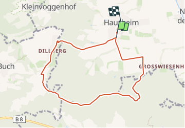
7,3 km | 8,4 km-effort
1h 53min
![](https://static1.geolcdn.com/siteimages/upload/files/16400158638029165_repeat_loop_refresh_sync_direction_icon.png)
Nein
![Tour Zu Fuß Postbauer-Heng - Ebenbühlweg - Photo](https://media.geolcdn.com/t/375/260/a9d91b06-96ad-4b4a-a5f9-ded4702d7ace.jpeg&format=jpg&maxdim=2)
![Zu Fuß Zu Fuß](https://static1.geolcdn.com/sitytour/trail-icons/100.png)
Ebenbühlweg
Zu Fuß
Einfach
Postbauer-Heng,
Bayern,
Landkreis Neumarkt in der Oberpfalz,
Germany
![](/images/other/stat-length.png)
16,7 km | 19,3 km-effort
4h 22min
![](https://static1.geolcdn.com/siteimages/upload/files/16400158638029165_repeat_loop_refresh_sync_direction_icon.png)
Nein
![Tour Zu Fuß Berg b.Neumarkt i.d.OPf. - Leonhardsweg - Photo](https://media.geolcdn.com/t/375/260/c42e2138-343f-43bd-b7cf-43eaac1532ac.jpeg&format=jpg&maxdim=2)
![Zu Fuß Zu Fuß](https://static1.geolcdn.com/sitytour/trail-icons/100.png)
Leonhardsweg
Zu Fuß
Einfach
Berg b.Neumarkt i.d.OPf.,
Bayern,
Landkreis Neumarkt in der Oberpfalz,
Germany
![](/images/other/stat-length.png)
9,2 km | 11,3 km-effort
2h 33min
![](https://static1.geolcdn.com/siteimages/upload/files/16400158638029165_repeat_loop_refresh_sync_direction_icon.png)
Ja
![Tour Zu Fuß Postbauer-Heng - Beerenschlag-Weg - Photo](https://media.geolcdn.com/t/375/260/adce6f83-7736-4972-bc43-b055fcd2ffd8.jpeg&format=jpg&maxdim=2)
![Zu Fuß Zu Fuß](https://static1.geolcdn.com/sitytour/trail-icons/100.png)
Beerenschlag-Weg
Zu Fuß
Einfach
Postbauer-Heng,
Bayern,
Landkreis Neumarkt in der Oberpfalz,
Germany
![](/images/other/stat-length.png)
7,2 km | 8,3 km-effort
1h 53min
![](https://static1.geolcdn.com/siteimages/upload/files/16400158638029165_repeat_loop_refresh_sync_direction_icon.png)
Nein
![Tour Zu Fuß Berg b.Neumarkt i.d.OPf. - Kaltenbach-Weg - Photo](https://media.geolcdn.com/t/375/260/70132e7e-9f3f-4787-8f28-d294672864ef.jpeg&format=jpg&maxdim=2)
![Zu Fuß Zu Fuß](https://static1.geolcdn.com/sitytour/trail-icons/100.png)
Kaltenbach-Weg
Zu Fuß
Einfach
Berg b.Neumarkt i.d.OPf.,
Bayern,
Landkreis Neumarkt in der Oberpfalz,
Germany
![](/images/other/stat-length.png)
4 km | 5,7 km-effort
1h 17min
![](https://static1.geolcdn.com/siteimages/upload/files/16400158638029165_repeat_loop_refresh_sync_direction_icon.png)
Nein
![Tour Zu Fuß Neumarkt in der Oberpfalz - TyrolsbergerWaldrundweg - Photo](https://media.geolcdn.com/t/375/260/1e967018-a4fc-44ba-bcfa-c479fca281f8.jpeg&format=jpg&maxdim=2)
![Zu Fuß Zu Fuß](https://static1.geolcdn.com/sitytour/trail-icons/100.png)
TyrolsbergerWaldrundweg
Zu Fuß
Einfach
Neumarkt in der Oberpfalz,
Bayern,
Landkreis Neumarkt in der Oberpfalz,
Germany
![](/images/other/stat-length.png)
4,8 km | 6,1 km-effort
1h 23min
![](https://static1.geolcdn.com/siteimages/upload/files/16400158638029165_repeat_loop_refresh_sync_direction_icon.png)
Nein
![Tour Zu Fuß Burgthann - Burgthann - Photo](https://media.geolcdn.com/t/375/260/9a20d899-4e2f-4da7-82f9-8d73a0b723c3.jpeg&format=jpg&maxdim=2)
![Zu Fuß Zu Fuß](https://static1.geolcdn.com/sitytour/trail-icons/100.png)
Burgthann
Zu Fuß
Einfach
Burgthann,
Bayern,
Landkreis Nürnberger Land,
Germany
![](/images/other/stat-length.png)
5,3 km | 7,3 km-effort
1h 40min
![](https://static1.geolcdn.com/siteimages/upload/files/16400158638029165_repeat_loop_refresh_sync_direction_icon.png)
Nein
![Tour Zu Fuß Postbauer-Heng - Goldhutweg - Photo](https://media.geolcdn.com/t/375/260/cdab7971-b641-4d8b-9dce-9da3a63af62a.jpeg&format=jpg&maxdim=2)
![Zu Fuß Zu Fuß](https://static1.geolcdn.com/sitytour/trail-icons/100.png)
Goldhutweg
Zu Fuß
Einfach
Postbauer-Heng,
Bayern,
Landkreis Neumarkt in der Oberpfalz,
Germany
![](/images/other/stat-length.png)
6 km | 7,3 km-effort
1h 39min
![](https://static1.geolcdn.com/siteimages/upload/files/16400158638029165_repeat_loop_refresh_sync_direction_icon.png)
Nein
![Tour Zu Fuß Postbauer-Heng - Kleine Dillbergrunde - Photo](https://media.geolcdn.com/t/375/260/d8a28d37-0f7c-4f35-bebe-49ad9b83f7e4.jpeg&format=jpg&maxdim=2)
![Zu Fuß Zu Fuß](https://static1.geolcdn.com/sitytour/trail-icons/100.png)
Kleine Dillbergrunde
Zu Fuß
Einfach
Postbauer-Heng,
Bayern,
Landkreis Neumarkt in der Oberpfalz,
Germany
![](/images/other/stat-length.png)
6,3 km | 8,4 km-effort
1h 53min
![](https://static1.geolcdn.com/siteimages/upload/files/16400158638029165_repeat_loop_refresh_sync_direction_icon.png)
Nein