![](/images/other/stat-length.png)
![Tour Zu Fuß Wolnzach - Hopfenlehrpfad - Photo](https://media.geolcdn.com/t/1900/400/610778ab-73c5-4458-b65e-4d54873d127e.jpeg&format=pjpeg&maxdim=2)
Hopfenlehrpfad
SityTrail - itinéraires balisés pédestres
Tous les sentiers balisés d’Europe GUIDE+
![Länge](/images/other/stat-length.png)
Länge
3,4 km
![Maximale Höhe](https://static1.geolcdn.com/siteimages/upload/files/1508320355ic_sort_altitude_max_24dp.png)
Maximale Höhe
475 m
![Positive Höhendifferenz](https://static1.geolcdn.com/siteimages/upload/files/1508320355ic_sort_den_pos_24dp.png)
Positive Höhendifferenz
57 m
![Km-Effort](/images/other/stat-length.png)
Km-Effort
4,2 km
![Min. Höhe](https://static1.geolcdn.com/siteimages/upload/files/1508320355ic_sort_altitude_min_24dp.png)
Min. Höhe
414 m
![Negative Höhendifferenz](https://static1.geolcdn.com/siteimages/upload/files/1508320355ic_sort_den_neg_24dp.png)
Negative Höhendifferenz
64 m
![Boucle](https://static1.geolcdn.com/siteimages/upload/files/16400158638029165_repeat_loop_refresh_sync_direction_icon.png)
Boucle
Nein
Kennzeichnung
Erstellungsdatum :
2022-02-11 13:06:21.112
Letzte Änderung :
2022-02-11 13:06:21.112
![Zu Fuß](https://static1.geolcdn.com/sitytour/trail-icons/100.png)
56m
Schwierigkeit : Einfach
![Scannen Sie diesen QR-Code, um die Tour in der SityTrail-Anwendung zu öffnen](https://capi.geolives.com/qq0zvz2zws4bq2lad0pu/sitytour/trails/3089155/qr.png?size=200)
Kostenlosegpshiking-Anwendung
Über SityTrail
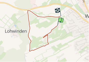
Tour Zu Fuß von 3,4 km verfügbar auf Bayern, Landkreis Pfaffenhofen an der Ilm, Wolnzach. Diese Tour wird von SityTrail - itinéraires balisés pédestres vorgeschlagen.
Beschreibung
Trail created by Gemeinde Wolnzach.
Website: https://www.wolnzach.de/index.php?id=333,72
Ort
Land:
Germany
Region :
Bayern
Abteilung/Provinz :
Landkreis Pfaffenhofen an der Ilm
Kommune :
Wolnzach
Standort:
Unknown
Gehen Sie:(Dec)
Gehen Sie:(UTM)
692409 ; 5386610 (32U) N.
Kommentare
Touren in der Umgebung
![Tour Zu Fuß Wolnzach - Lauf 10 - Photo](https://media.geolcdn.com/t/375/260/610778ab-73c5-4458-b65e-4d54873d127e.jpeg&format=jpg&maxdim=2)
![Zu Fuß Zu Fuß](https://static1.geolcdn.com/sitytour/trail-icons/100.png)
Lauf 10
Zu Fuß
Einfach
Wolnzach,
Bayern,
Landkreis Pfaffenhofen an der Ilm,
Germany
![](/images/other/stat-length.png)
9,8 km | 11,3 km-effort
2h 33min
![](https://static1.geolcdn.com/siteimages/upload/files/16400158638029165_repeat_loop_refresh_sync_direction_icon.png)
Nein
![Tour Zu Fuß Wolnzach - Wanderweg 93a - Photo](https://media.geolcdn.com/t/375/260/ext.jpg?maxdim=2&url=https%3A%2F%2Fstatic1.geolcdn.com%2Fsiteimages%2Fupload%2Ffiles%2F1545311037marcheuse_200dpi.jpg)
![Zu Fuß Zu Fuß](https://static1.geolcdn.com/sitytour/trail-icons/100.png)
Wanderweg 93a
Zu Fuß
Einfach
Wolnzach,
Bayern,
Landkreis Pfaffenhofen an der Ilm,
Germany
![](/images/other/stat-length.png)
14,1 km | 16,3 km-effort
3h 42min
![](https://static1.geolcdn.com/siteimages/upload/files/16400158638029165_repeat_loop_refresh_sync_direction_icon.png)
Ja
![Tour Zu Fuß Wolnzach - Wanderweg 94 - Photo](https://media.geolcdn.com/t/375/260/ext.jpg?maxdim=2&url=https%3A%2F%2Fstatic1.geolcdn.com%2Fsiteimages%2Fupload%2Ffiles%2F1545311037marcheuse_200dpi.jpg)
![Zu Fuß Zu Fuß](https://static1.geolcdn.com/sitytour/trail-icons/100.png)
Wanderweg 94
Zu Fuß
Einfach
Wolnzach,
Bayern,
Landkreis Pfaffenhofen an der Ilm,
Germany
![](/images/other/stat-length.png)
9,3 km | 10,5 km-effort
2h 23min
![](https://static1.geolcdn.com/siteimages/upload/files/16400158638029165_repeat_loop_refresh_sync_direction_icon.png)
Ja
![Tour Zu Fuß Wolnzach - Wanderweg 93 - Photo](https://media.geolcdn.com/t/375/260/ext.jpg?maxdim=2&url=https%3A%2F%2Fstatic1.geolcdn.com%2Fsiteimages%2Fupload%2Ffiles%2F1545311037marcheuse_200dpi.jpg)
![Zu Fuß Zu Fuß](https://static1.geolcdn.com/sitytour/trail-icons/100.png)
Wanderweg 93
Zu Fuß
Einfach
Wolnzach,
Bayern,
Landkreis Pfaffenhofen an der Ilm,
Germany
![](/images/other/stat-length.png)
6,1 km | 6,9 km-effort
1h 33min
![](https://static1.geolcdn.com/siteimages/upload/files/16400158638029165_repeat_loop_refresh_sync_direction_icon.png)
Ja
![Tour Zu Fuß Geisenfeld - Wanderweg 39c - Photo](https://media.geolcdn.com/t/375/260/ext.jpg?maxdim=2&url=https%3A%2F%2Fstatic1.geolcdn.com%2Fsiteimages%2Fupload%2Ffiles%2F1545311037marcheuse_200dpi.jpg)
![Zu Fuß Zu Fuß](https://static1.geolcdn.com/sitytour/trail-icons/100.png)
Wanderweg 39c
Zu Fuß
Einfach
Geisenfeld,
Bayern,
Landkreis Pfaffenhofen an der Ilm,
Germany
![](/images/other/stat-length.png)
7,8 km | 8,8 km-effort
2h 0min
![](https://static1.geolcdn.com/siteimages/upload/files/16400158638029165_repeat_loop_refresh_sync_direction_icon.png)
Ja
![Tour Zu Fuß Geisenfeld - Wanderweg 39b - Photo](https://media.geolcdn.com/t/375/260/ext.jpg?maxdim=2&url=https%3A%2F%2Fstatic1.geolcdn.com%2Fsiteimages%2Fupload%2Ffiles%2F1545311037marcheuse_200dpi.jpg)
![Zu Fuß Zu Fuß](https://static1.geolcdn.com/sitytour/trail-icons/100.png)
Wanderweg 39b
Zu Fuß
Einfach
Geisenfeld,
Bayern,
Landkreis Pfaffenhofen an der Ilm,
Germany
![](/images/other/stat-length.png)
6 km | 6,9 km-effort
1h 33min
![](https://static1.geolcdn.com/siteimages/upload/files/16400158638029165_repeat_loop_refresh_sync_direction_icon.png)
Ja
![Tour Zu Fuß Geisenfeld - Wanderweg 39a - Photo](https://media.geolcdn.com/t/375/260/ext.jpg?maxdim=2&url=https%3A%2F%2Fstatic1.geolcdn.com%2Fsiteimages%2Fupload%2Ffiles%2F1545311037marcheuse_200dpi.jpg)
![Zu Fuß Zu Fuß](https://static1.geolcdn.com/sitytour/trail-icons/100.png)
Wanderweg 39a
Zu Fuß
Einfach
Geisenfeld,
Bayern,
Landkreis Pfaffenhofen an der Ilm,
Germany
![](/images/other/stat-length.png)
3,9 km | 4,4 km-effort
59min
![](https://static1.geolcdn.com/siteimages/upload/files/16400158638029165_repeat_loop_refresh_sync_direction_icon.png)
Ja
![Tour Zu Fuß Geisenfeld - Wanderweg 39 - Photo](https://media.geolcdn.com/t/375/260/ext.jpg?maxdim=2&url=https%3A%2F%2Fstatic1.geolcdn.com%2Fsiteimages%2Fupload%2Ffiles%2F1545311037marcheuse_200dpi.jpg)
![Zu Fuß Zu Fuß](https://static1.geolcdn.com/sitytour/trail-icons/100.png)
Wanderweg 39
Zu Fuß
Einfach
Geisenfeld,
Bayern,
Landkreis Pfaffenhofen an der Ilm,
Germany
![](/images/other/stat-length.png)
9,9 km | 11,2 km-effort
2h 32min
![](https://static1.geolcdn.com/siteimages/upload/files/16400158638029165_repeat_loop_refresh_sync_direction_icon.png)
Ja