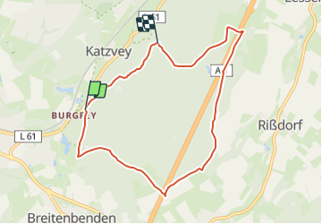
![](/images/other/stat-length.png)
![Tour Zu Fuß Mechernich - EifelSchleife Ab in den Wald! - Photo](https://media.geolcdn.com/t/1900/400/d165f3a5-b04e-49ee-afc9-4ded17a5a0be.jpeg&format=pjpeg&maxdim=2)
EifelSchleife Ab in den Wald!
SityTrail - itinéraires balisés pédestres
Tous les sentiers balisés d’Europe GUIDE+
![Länge](/images/other/stat-length.png)
![Maximale Höhe](https://static1.geolcdn.com/siteimages/upload/files/1508320355ic_sort_altitude_max_24dp.png)
![Positive Höhendifferenz](https://static1.geolcdn.com/siteimages/upload/files/1508320355ic_sort_den_pos_24dp.png)
![Km-Effort](/images/other/stat-length.png)
![Min. Höhe](https://static1.geolcdn.com/siteimages/upload/files/1508320355ic_sort_altitude_min_24dp.png)
![Negative Höhendifferenz](https://static1.geolcdn.com/siteimages/upload/files/1508320355ic_sort_den_neg_24dp.png)
![Boucle](https://static1.geolcdn.com/siteimages/upload/files/16400158638029165_repeat_loop_refresh_sync_direction_icon.png)
![Zu Fuß](https://static1.geolcdn.com/sitytour/trail-icons/100.png)
2h38
Schwierigkeit : Einfach
![Scannen Sie diesen QR-Code, um die Tour in der SityTrail-Anwendung zu öffnen](https://capi.geolives.com/qq0zvz2zws4bq2lad0pu/sitytour/trails/3088325/qr.png?size=200)
Kostenlosegpshiking-Anwendung
Über SityTrail
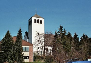
Tour Zu Fuß von 9,3 km verfügbar auf Nordrhein-Westfalen, Kreis Euskirchen, Mechernich. Diese Tour wird von SityTrail - itinéraires balisés pédestres vorgeschlagen.
Beschreibung
Trail created by Nordeifel Tourismus GmbH.
Symbol: quadratisches Logo oben blaue Fläche (Himmel) unten grüne Fläche (Berg/Landschaft), unten bis nach oben auf dem Grünen geschlängelt weiße Linie (Weg), oben links in weißer Schrift „EifelSchleifen“
Ort
Kommentare
Touren in der Umgebung
![Tour Zu Fuß Mechernich - EifelSpur Soweit das Auge reicht - Photo](https://media.geolcdn.com/t/375/260/c70cb833-41f8-4d90-824d-5fcd1544f78d.jpeg&format=jpg&maxdim=2)
![Zu Fuß Zu Fuß](https://static1.geolcdn.com/sitytour/trail-icons/100.png)
Zu Fuß
![](/images/other/stat-length.png)
![](https://static1.geolcdn.com/siteimages/upload/files/16400158638029165_repeat_loop_refresh_sync_direction_icon.png)
![Tour Zu Fuß Mechernich - EifelSchleife Eickser Busch - Photo](https://media.geolcdn.com/t/375/260/072e47f6-f82f-4b70-8d89-5bfb8fc4db70.jpeg&format=jpg&maxdim=2)
![Zu Fuß Zu Fuß](https://static1.geolcdn.com/sitytour/trail-icons/100.png)
Zu Fuß
![](/images/other/stat-length.png)
![](https://static1.geolcdn.com/siteimages/upload/files/16400158638029165_repeat_loop_refresh_sync_direction_icon.png)
![Tour Zu Fuß Mechernich - EifelSchleife Altusknipp-Weg - Photo](https://media.geolcdn.com/t/375/260/a1c826eb-46f8-4939-a400-ff876a4c0f14.jpeg&format=jpg&maxdim=2)
![Zu Fuß Zu Fuß](https://static1.geolcdn.com/sitytour/trail-icons/100.png)
Zu Fuß
![](/images/other/stat-length.png)
![](https://static1.geolcdn.com/siteimages/upload/files/16400158638029165_repeat_loop_refresh_sync_direction_icon.png)
![Tour Zu Fuß Mechernich - EifelSchleife Kommerner Fachwerkidylle - Photo](https://media.geolcdn.com/t/375/260/1ca075b4-2c73-439c-8adb-5a0359d22b2d.jpeg&format=jpg&maxdim=2)
![Zu Fuß Zu Fuß](https://static1.geolcdn.com/sitytour/trail-icons/100.png)
Zu Fuß
![](/images/other/stat-length.png)
![](https://static1.geolcdn.com/siteimages/upload/files/16400158638029165_repeat_loop_refresh_sync_direction_icon.png)
![Tour Zu Fuß Mechernich - EifelSchleife Burg Satzvey - Photo](https://media.geolcdn.com/t/375/260/06c6e2b8-53ab-44c9-a958-97487b3c0d6f.jpeg&format=jpg&maxdim=2)
![Zu Fuß Zu Fuß](https://static1.geolcdn.com/sitytour/trail-icons/100.png)
Zu Fuß
![](/images/other/stat-length.png)
![](https://static1.geolcdn.com/siteimages/upload/files/16400158638029165_repeat_loop_refresh_sync_direction_icon.png)
![Tour Zu Fuß Mechernich - Eifeltor Panorama - Route - Photo](https://media.geolcdn.com/t/375/260/072e47f6-f82f-4b70-8d89-5bfb8fc4db70.jpeg&format=jpg&maxdim=2)
![Zu Fuß Zu Fuß](https://static1.geolcdn.com/sitytour/trail-icons/100.png)
Zu Fuß
![](/images/other/stat-length.png)
![](https://static1.geolcdn.com/siteimages/upload/files/16400158638029165_repeat_loop_refresh_sync_direction_icon.png)
![Tour Zu Fuß Mechernich - Hochwildpark Rheinland - Route - Photo](https://media.geolcdn.com/t/375/260/06c6e2b8-53ab-44c9-a958-97487b3c0d6f.jpeg&format=jpg&maxdim=2)
![Zu Fuß Zu Fuß](https://static1.geolcdn.com/sitytour/trail-icons/100.png)
Zu Fuß
![](/images/other/stat-length.png)
![](https://static1.geolcdn.com/siteimages/upload/files/16400158638029165_repeat_loop_refresh_sync_direction_icon.png)
![Tour Zu Fuß Mechernich - EifelSchleife Stockertblick und Herkelstein - Photo](https://media.geolcdn.com/t/375/260/a0b59c05-229a-448d-ada4-df53ccc7f739.jpeg&format=jpg&maxdim=2)
![Zu Fuß Zu Fuß](https://static1.geolcdn.com/sitytour/trail-icons/100.png)
Zu Fuß
![](/images/other/stat-length.png)
![](https://static1.geolcdn.com/siteimages/upload/files/16400158638029165_repeat_loop_refresh_sync_direction_icon.png)
![Tour Zu Fuß Mechernich - Wachendorf Rundweg 4 - Photo](https://media.geolcdn.com/t/375/260/36c4d9f8-77e2-49b2-86ee-a878aa6514ba.jpeg&format=jpg&maxdim=2)
![Zu Fuß Zu Fuß](https://static1.geolcdn.com/sitytour/trail-icons/100.png)
Zu Fuß
![](/images/other/stat-length.png)
![](https://static1.geolcdn.com/siteimages/upload/files/16400158638029165_repeat_loop_refresh_sync_direction_icon.png)