![](/images/other/stat-length.png)
![Tour Wandern Lauzach - Boucles du Guernec, Lauzach - Photo](https://media.geolcdn.com/t/1900/400/ext.pjpeg?maxdim=2&url=https%3A%2F%2Fstatic1.geolcdn.com%2Fsiteimages%2Fupload%2Ffiles%2F1553511878bg_sport_marche.png)
Boucles du Guernec, Lauzach
PAM2235
Benutzer
![Länge](/images/other/stat-length.png)
![Maximale Höhe](https://static1.geolcdn.com/siteimages/upload/files/1508320355ic_sort_altitude_max_24dp.png)
![Positive Höhendifferenz](https://static1.geolcdn.com/siteimages/upload/files/1508320355ic_sort_den_pos_24dp.png)
![Km-Effort](/images/other/stat-length.png)
![Min. Höhe](https://static1.geolcdn.com/siteimages/upload/files/1508320355ic_sort_altitude_min_24dp.png)
![Negative Höhendifferenz](https://static1.geolcdn.com/siteimages/upload/files/1508320355ic_sort_den_neg_24dp.png)
![Boucle](https://static1.geolcdn.com/siteimages/upload/files/16400158638029165_repeat_loop_refresh_sync_direction_icon.png)
![Wandern](https://static1.geolcdn.com/sitytour/trail-icons/101.png)
2h25
Schwierigkeit : Medium
![Scannen Sie diesen QR-Code, um die Tour in der SityTrail-Anwendung zu öffnen](https://capi.geolives.com/qq0zvz2zws4bq2lad0pu/sitytour/trails/3086814/qr.png?size=200)
Kostenlosegpshiking-Anwendung
Über SityTrail
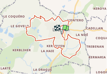
Tour Wandern von 9,8 km verfügbar auf Bretagne, Morbihan, Lauzach. Diese Tour wird von PAM2235 vorgeschlagen.
Beschreibung
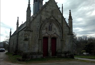
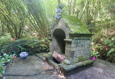
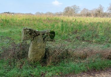
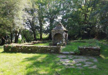
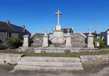
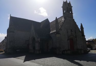
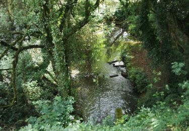
Située au sud du Pays de Questembert, la commune de Lauzach est proche de la rivière de Pénerf et des plages de Damgan. Au long des rives du Guernec, ce circuit sillonne la campagne, et invite à découvrir les monuments comme le Mémorial des guerres d’Indochine et la Chapelle St-Michel. Balisage jaune circuit PR©. Liaison possible vers Berric.
Ort
Kommentare
Touren in der Umgebung
![Tour Wandern Berric - Berric - Circuit des Vertus - Photo](https://media.geolcdn.com/t/375/260/ext.jpg?maxdim=2&url=https%3A%2F%2Fservices.sitytrail.com%2FGeolivesWS%2FDownloadMedia.ashx%3FTrailID%3D178624%26Media%3Da047e8b5-5cf9-4545-b7b7-9961e79ce05d.jpg)
![Wandern Wandern](https://static1.geolcdn.com/sitytour/trail-icons/101.png)
Wandern
![](/images/other/stat-length.png)
![](https://static1.geolcdn.com/siteimages/upload/files/16400158638029165_repeat_loop_refresh_sync_direction_icon.png)
![Tour Wandern Berric - PR_56_Berric_AA_01_Circuit1b_Boucle-Des-Vertus_20240825 - Photo](https://media.geolcdn.com/t/375/260/d52766e7-e6f2-4271-86a5-49d1268fc4b5.jpg&format=jpg&maxdim=2)
![Wandern Wandern](https://static1.geolcdn.com/sitytour/trail-icons/101.png)
Wandern
![](/images/other/stat-length.png)
![](https://static1.geolcdn.com/siteimages/upload/files/16400158638029165_repeat_loop_refresh_sync_direction_icon.png)
![Tour Wandern Lauzach - PR_56_Lauzach_AA_01_Circuit1b_Boucles-Du-Guernec_20240210 - Photo](https://media.geolcdn.com/t/375/260/97a1b0e1-8a16-4eaf-9878-7259027333e5.jpg&format=jpg&maxdim=2)
![Wandern Wandern](https://static1.geolcdn.com/sitytour/trail-icons/101.png)
Wandern
![](/images/other/stat-length.png)
![](https://static1.geolcdn.com/siteimages/upload/files/16400158638029165_repeat_loop_refresh_sync_direction_icon.png)
![Tour Wandern Theix-Noyalo - GRP_Lanvaux_AK_11_Theix_St-Nolf_20210615 - Photo](https://media.geolcdn.com/t/375/260/b7d9e276-6ec7-442e-9d5d-291058f86d11.jpg&format=jpg&maxdim=2)
![Wandern Wandern](https://static1.geolcdn.com/sitytour/trail-icons/101.png)
Wandern
![](/images/other/stat-length.png)
![](https://static1.geolcdn.com/siteimages/upload/files/16400158638029165_repeat_loop_refresh_sync_direction_icon.png)
![Tour Wandern Berric - GRP_Lanvaux_AJ_10_Berric_Theix_20210608 - Photo](https://media.geolcdn.com/t/375/260/de084bea-3302-489e-8149-e594a415d03e.jpg&format=jpg&maxdim=2)
![Wandern Wandern](https://static1.geolcdn.com/sitytour/trail-icons/101.png)
Wandern
![](/images/other/stat-length.png)
![](https://static1.geolcdn.com/siteimages/upload/files/16400158638029165_repeat_loop_refresh_sync_direction_icon.png)
![Tour Wandern Sulniac - 215- Boucle Le Gorvello Theix - Photo](https://media.geolcdn.com/t/375/260/70c6538d-d3f2-405b-adce-eea4c8c52a77.jpg&format=jpg&maxdim=2)
![Wandern Wandern](https://static1.geolcdn.com/sitytour/trail-icons/101.png)
Wandern
![](/images/other/stat-length.png)
![](https://static1.geolcdn.com/siteimages/upload/files/16400158638029165_repeat_loop_refresh_sync_direction_icon.png)
![Tour Wandern Questembert - 181 La boucle de Brangolo - Photo](https://media.geolcdn.com/t/375/260/b7b3446e-266b-4b93-8f5c-6e49ba47c6ad.jpg&format=jpg&maxdim=2)
![Wandern Wandern](https://static1.geolcdn.com/sitytour/trail-icons/101.png)
Wandern
![](/images/other/stat-length.png)
![](https://static1.geolcdn.com/siteimages/upload/files/16400158638029165_repeat_loop_refresh_sync_direction_icon.png)
![Tour Wandern Berric - Berric/Le Gorvello - Photo](https://media.geolcdn.com/t/375/260/d5c01ad4-70fa-432b-980c-f4dcfdd1a4a8.jpg&format=jpg&maxdim=2)
![Wandern Wandern](https://static1.geolcdn.com/sitytour/trail-icons/101.png)
Wandern
![](/images/other/stat-length.png)
![](https://static1.geolcdn.com/siteimages/upload/files/16400158638029165_repeat_loop_refresh_sync_direction_icon.png)
![Tour Wandern Berric - 160 Rando le Gorvello - Photo](https://media.geolcdn.com/t/375/260/deb32f4a-81c5-4a01-9982-071cb6b3e8b0.jpg&format=jpg&maxdim=2)
![Wandern Wandern](https://static1.geolcdn.com/sitytour/trail-icons/101.png)
Wandern
![](/images/other/stat-length.png)
![](https://static1.geolcdn.com/siteimages/upload/files/16400158638029165_repeat_loop_refresh_sync_direction_icon.png)