![](/images/other/stat-length.png)
![Tour Schneeschuhwandern Métabief - Les hauteurs de Metabief - Photo](https://media.geolcdn.com/t/1900/400/33f04111-8af2-4c09-927f-ba23e9559149.jpg&format=pjpeg&maxdim=2)
Les hauteurs de Metabief
zefreefly
Benutzer
![Länge](/images/other/stat-length.png)
Länge
15,5 km
![Maximale Höhe](https://static1.geolcdn.com/siteimages/upload/files/1508320355ic_sort_altitude_max_24dp.png)
Maximale Höhe
1426 m
![Positive Höhendifferenz](https://static1.geolcdn.com/siteimages/upload/files/1508320355ic_sort_den_pos_24dp.png)
Positive Höhendifferenz
551 m
![Km-Effort](/images/other/stat-length.png)
Km-Effort
23 km
![Min. Höhe](https://static1.geolcdn.com/siteimages/upload/files/1508320355ic_sort_altitude_min_24dp.png)
Min. Höhe
1007 m
![Negative Höhendifferenz](https://static1.geolcdn.com/siteimages/upload/files/1508320355ic_sort_den_neg_24dp.png)
Negative Höhendifferenz
542 m
![Boucle](https://static1.geolcdn.com/siteimages/upload/files/16400158638029165_repeat_loop_refresh_sync_direction_icon.png)
Boucle
Ja
Erstellungsdatum :
2022-02-10 08:58:08.0
Letzte Änderung :
2022-02-10 14:22:12.222
![Schneeschuhwandern](https://static1.geolcdn.com/sitytour/trail-icons/504.png)
3h51
Schwierigkeit : Medium
![Scannen Sie diesen QR-Code, um die Tour in der SityTrail-Anwendung zu öffnen](https://capi.geolives.com/qq0zvz2zws4bq2lad0pu/sitytour/trails/3086349/qr.png?size=200)
Kostenlosegpshiking-Anwendung
Über SityTrail
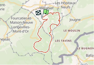
Tour Schneeschuhwandern von 15,5 km verfügbar auf Burgund und Freigrafschaft, Doubs, Métabief. Diese Tour wird von zefreefly vorgeschlagen.
Beschreibung
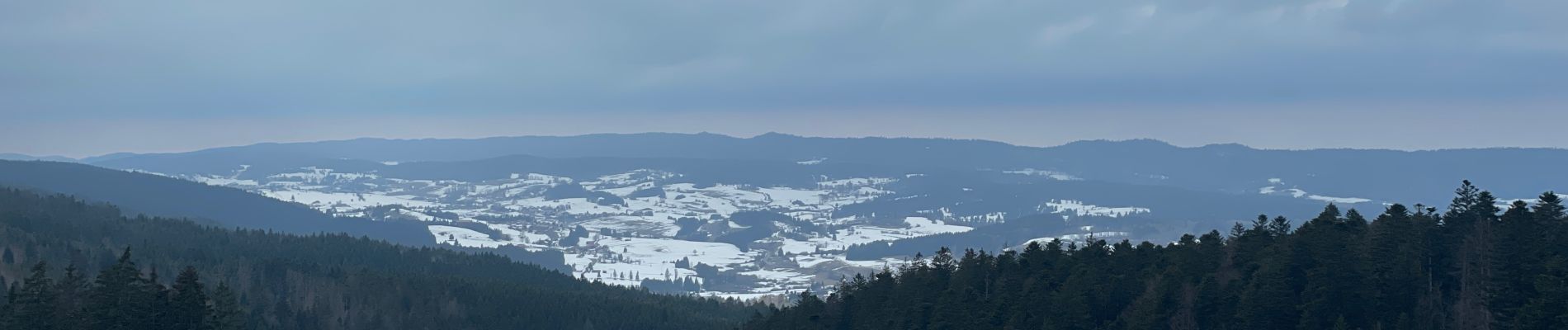
Boucle qui vous emmène vers le point de vue du Mont d’Or
Belle Rando avec une montée bien raide.
Ort
Land:
France
Region :
Burgund und Freigrafschaft
Abteilung/Provinz :
Doubs
Kommune :
Métabief
Standort:
Unknown
Gehen Sie:(Dec)
Gehen Sie:(UTM)
297305 ; 5182439 (32T) N.
Kommentare
Touren in der Umgebung
![Tour Wandern Métabief - GTJ Metabief - Pontarlier - Photo](https://media.geolcdn.com/t/375/260/ext.jpg?maxdim=2&url=https%3A%2F%2Fstatic1.geolcdn.com%2Fsiteimages%2Fupload%2Ffiles%2F1553511878bg_sport_marche.png)
![Wandern Wandern](https://static1.geolcdn.com/sitytour/trail-icons/101.png)
GTJ Metabief - Pontarlier
Wandern
Medium
(1)
Métabief,
Burgund und Freigrafschaft,
Doubs,
France
![](/images/other/stat-length.png)
25 km | 35 km-effort
7h 17min
![](https://static1.geolcdn.com/siteimages/upload/files/16400158638029165_repeat_loop_refresh_sync_direction_icon.png)
Nein
![Tour Wandern Métabief - Le mont d 0r - Photo](https://media.geolcdn.com/t/375/260/dfbdcbfb-f5e1-43ae-8768-86e7f8471cb6.jpg&format=jpg&maxdim=2)
![Wandern Wandern](https://static1.geolcdn.com/sitytour/trail-icons/101.png)
Le mont d 0r
Wandern
Medium
Métabief,
Burgund und Freigrafschaft,
Doubs,
France
![](/images/other/stat-length.png)
18,5 km | 25 km-effort
4h 38min
![](https://static1.geolcdn.com/siteimages/upload/files/16400158638029165_repeat_loop_refresh_sync_direction_icon.png)
Nein
![Tour Wandern Saint-Antoine - Boucle du fort St Antoine - Photo](https://media.geolcdn.com/t/375/260/39387965-6cd2-4b9c-a9a7-b089cab08bc2.jpg&format=jpg&maxdim=2)
![Wandern Wandern](https://static1.geolcdn.com/sitytour/trail-icons/101.png)
Boucle du fort St Antoine
Wandern
Medium
Saint-Antoine,
Burgund und Freigrafschaft,
Doubs,
France
![](/images/other/stat-length.png)
4,8 km | 6,2 km-effort
1h 25min
![](https://static1.geolcdn.com/siteimages/upload/files/16400158638029165_repeat_loop_refresh_sync_direction_icon.png)
Ja
![Tour Wandern Rochejean - Mont d'or - Photo](https://media.geolcdn.com/t/375/260/22137291-8125-4d4b-9cc5-d81179db76e3.jpg&format=jpg&maxdim=2)
![Wandern Wandern](https://static1.geolcdn.com/sitytour/trail-icons/101.png)
Mont d'or
Wandern
Einfach
Rochejean,
Burgund und Freigrafschaft,
Doubs,
France
![](/images/other/stat-length.png)
11,9 km | 17,5 km-effort
4h 53min
![](https://static1.geolcdn.com/siteimages/upload/files/16400158638029165_repeat_loop_refresh_sync_direction_icon.png)
Ja
![Tour Zu Fuß Malbuisson - Sentier du Tour du Lac - Photo](https://media.geolcdn.com/t/375/260/ec9f6be9-4d56-4db2-b65f-5890444a2963.jpeg&format=jpg&maxdim=2)
![Zu Fuß Zu Fuß](https://static1.geolcdn.com/sitytour/trail-icons/100.png)
Sentier du Tour du Lac
Zu Fuß
Einfach
Malbuisson,
Burgund und Freigrafschaft,
Doubs,
France
![](/images/other/stat-length.png)
16 km | 19,9 km-effort
4h 30min
![](https://static1.geolcdn.com/siteimages/upload/files/16400158638029165_repeat_loop_refresh_sync_direction_icon.png)
Nein
![Tour Nordic Walking Malbuisson - Fort St Antoine - Photo](https://media.geolcdn.com/t/375/260/fe4e7a22-394a-4da9-be49-1254fdb85bde.jpg&format=jpg&maxdim=2)
![Nordic Walking Nordic Walking](https://static1.geolcdn.com/sitytour/trail-icons/102.png)
Fort St Antoine
Nordic Walking
Einfach
Malbuisson,
Burgund und Freigrafschaft,
Doubs,
France
![](/images/other/stat-length.png)
5,8 km | 7,3 km-effort
2h 21min
![](https://static1.geolcdn.com/siteimages/upload/files/16400158638029165_repeat_loop_refresh_sync_direction_icon.png)
Ja
![Tour Langlaufen Les Hôpitaux-Vieux - Les Essarts - Photo](https://media.geolcdn.com/t/375/260/133bf42f-84e7-4637-b480-7581e8a779ca.jpg&format=jpg&maxdim=2)
![Langlaufen Langlaufen](https://static1.geolcdn.com/sitytour/trail-icons/502.png)
Les Essarts
Langlaufen
Einfach
Les Hôpitaux-Vieux,
Burgund und Freigrafschaft,
Doubs,
France
![](/images/other/stat-length.png)
6,5 km | 8,1 km-effort
2h 3min
![](https://static1.geolcdn.com/siteimages/upload/files/16400158638029165_repeat_loop_refresh_sync_direction_icon.png)
Ja
![Tour Wandern Jougne - La Jougnena - Photo](https://media.geolcdn.com/t/375/260/ext.jpg?maxdim=2&url=https%3A%2F%2Fstatic1.geolcdn.com%2Fsiteimages%2Fupload%2Ffiles%2F1553511878bg_sport_marche.png)
![Wandern Wandern](https://static1.geolcdn.com/sitytour/trail-icons/101.png)
La Jougnena
Wandern
Sehr schwierig
(1)
Jougne,
Burgund und Freigrafschaft,
Doubs,
France
![](/images/other/stat-length.png)
17,7 km | 24 km-effort
5h 32min
![](https://static1.geolcdn.com/siteimages/upload/files/16400158638029165_repeat_loop_refresh_sync_direction_icon.png)
Ja
![Tour Wandern Jougne - La poyette - Photo](https://media.geolcdn.com/t/375/260/7455827d-3f9e-4079-9524-3e53ae00a5a5.jpg&format=jpg&maxdim=2)
![Wandern Wandern](https://static1.geolcdn.com/sitytour/trail-icons/101.png)
La poyette
Wandern
Medium
Jougne,
Burgund und Freigrafschaft,
Doubs,
France
![](/images/other/stat-length.png)
11,8 km | 17,9 km-effort
4h 7min
![](https://static1.geolcdn.com/siteimages/upload/files/16400158638029165_repeat_loop_refresh_sync_direction_icon.png)
Ja