![](/images/other/stat-length.png)
![Tour Wandern Uhart-Mixe - Saint-Palais (Chapelle Soyarce et d'Harambels) - Photo](https://media.geolcdn.com/t/1900/400/ext.pjpeg?maxdim=2&url=https%3A%2F%2Fstatic1.geolcdn.com%2Fsiteimages%2Fupload%2Ffiles%2F1553511878bg_sport_marche.png)
Saint-Palais (Chapelle Soyarce et d'Harambels)
coco03
Benutzer
![Länge](/images/other/stat-length.png)
Länge
3,4 km
![Maximale Höhe](https://static1.geolcdn.com/siteimages/upload/files/1508320355ic_sort_altitude_max_24dp.png)
Maximale Höhe
288 m
![Positive Höhendifferenz](https://static1.geolcdn.com/siteimages/upload/files/1508320355ic_sort_den_pos_24dp.png)
Positive Höhendifferenz
129 m
![Km-Effort](/images/other/stat-length.png)
Km-Effort
5,2 km
![Min. Höhe](https://static1.geolcdn.com/siteimages/upload/files/1508320355ic_sort_altitude_min_24dp.png)
Min. Höhe
144 m
![Negative Höhendifferenz](https://static1.geolcdn.com/siteimages/upload/files/1508320355ic_sort_den_neg_24dp.png)
Negative Höhendifferenz
147 m
![Boucle](https://static1.geolcdn.com/siteimages/upload/files/16400158638029165_repeat_loop_refresh_sync_direction_icon.png)
Boucle
Nein
Erstellungsdatum :
2014-12-10 00:00:00.0
Letzte Änderung :
2014-12-10 00:00:00.0
![Wandern](https://static1.geolcdn.com/sitytour/trail-icons/101.png)
1h04
Schwierigkeit : Medium
![Scannen Sie diesen QR-Code, um die Tour in der SityTrail-Anwendung zu öffnen](https://capi.geolives.com/qq0zvz2zws4bq2lad0pu/sitytour/trails/308625/qr.png?size=200)
Kostenlosegpshiking-Anwendung
Über SityTrail
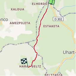
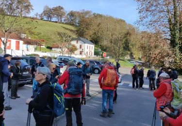
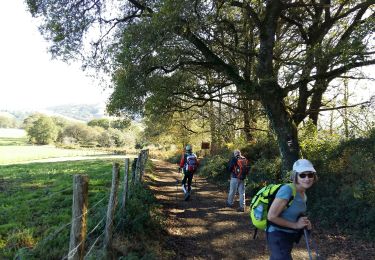
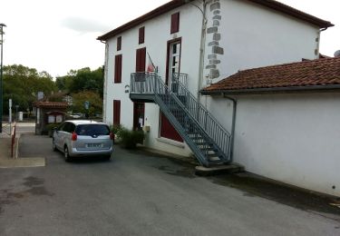
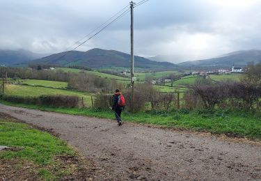
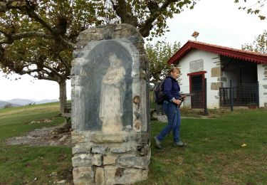
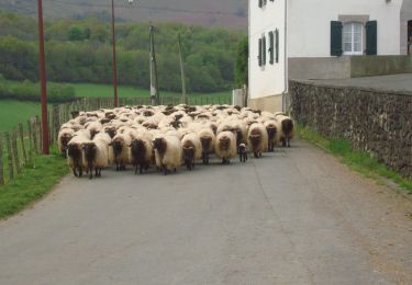
Tour Wandern von 3,4 km verfügbar auf Neu-Aquitanien, Pyrenäen-Atlantik, Uhart-Mixe. Diese Tour wird von coco03 vorgeschlagen.
Beschreibung
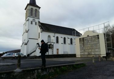
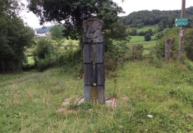
Sur le chemin de St Jacques de Compostelle, la Chapelle Soyarce et sa table d'orientation et enfin la Chapelle d'Harambels (l'intérieur est tout en bois)
7Km AR.
Ort
Land:
France
Region :
Neu-Aquitanien
Abteilung/Provinz :
Pyrenäen-Atlantik
Kommune :
Uhart-Mixe
Standort:
Unknown
Gehen Sie:(Dec)
Gehen Sie:(UTM)
659215 ; 4795692 (30T) N.
Kommentare
Touren in der Umgebung
![Tour Wandern Arhansus - Balade autour d'Arhansus - Photo](https://media.geolcdn.com/t/375/260/ext.jpg?maxdim=2&url=https%3A%2F%2Fservices.sitytrail.com%2FGeolivesWS%2FDownloadMedia.ashx%3FTrailID%3D111306%26Media%3D6955_1.jpg)
![Wandern Wandern](https://static1.geolcdn.com/sitytour/trail-icons/101.png)
Balade autour d'Arhansus
Wandern
Medium
(1)
Arhansus,
Neu-Aquitanien,
Pyrenäen-Atlantik,
France
![](/images/other/stat-length.png)
6,1 km | 8,9 km-effort
2h 0min
![](https://static1.geolcdn.com/siteimages/upload/files/16400158638029165_repeat_loop_refresh_sync_direction_icon.png)
Ja
![Tour Wandern Uhart-Mixe - UHART MIXE journée présidents et animateurs](https://media.geolcdn.com/t/375/260/2708b30b-c90c-4afe-a2c3-fc4432d8dcc2.jpg&format=jpg&maxdim=2)
![Wandern Wandern](https://static1.geolcdn.com/sitytour/trail-icons/101.png)
UHART MIXE journée présidents et animateurs "3870387"
Wandern
Schwierig
Uhart-Mixe,
Neu-Aquitanien,
Pyrenäen-Atlantik,
France
![](/images/other/stat-length.png)
10,2 km | 14,5 km-effort
3h 17min
![](https://static1.geolcdn.com/siteimages/upload/files/16400158638029165_repeat_loop_refresh_sync_direction_icon.png)
Ja
![Tour Wandern Ostabat-Asme - OSTABAT-ASME St Nicolas-Soyarze-Fntaine de la vierge G3](https://media.geolcdn.com/t/375/260/3d549841-31ce-4f5c-a0c8-5f78c7f7af4e.jpg&format=jpg&maxdim=2)
![Wandern Wandern](https://static1.geolcdn.com/sitytour/trail-icons/101.png)
OSTABAT-ASME St Nicolas-Soyarze-Fntaine de la vierge G3 "3518187"
Wandern
Schwierig
Ostabat-Asme,
Neu-Aquitanien,
Pyrenäen-Atlantik,
France
![](/images/other/stat-length.png)
11,7 km | 16,9 km-effort
3h 29min
![](https://static1.geolcdn.com/siteimages/upload/files/16400158638029165_repeat_loop_refresh_sync_direction_icon.png)
Ja
![Tour Wandern Uhart-Mixe - UHART-MIXE journée Presidents / animateurs](https://media.geolcdn.com/t/375/260/177f0667-f458-47f3-85ca-ac4813df1948.jpg&format=jpg&maxdim=2)
![Wandern Wandern](https://static1.geolcdn.com/sitytour/trail-icons/101.png)
UHART-MIXE journée Presidents / animateurs "3477163"
Wandern
Schwierig
(1)
Uhart-Mixe,
Neu-Aquitanien,
Pyrenäen-Atlantik,
France
![](/images/other/stat-length.png)
10,1 km | 14,4 km-effort
2h 48min
![](https://static1.geolcdn.com/siteimages/upload/files/16400158638029165_repeat_loop_refresh_sync_direction_icon.png)
Ja
![Tour Wandern Uhart-Mixe - UHART MIXE reco Circuit Urbeltz journee](https://media.geolcdn.com/t/375/260/45c7355a-71af-4b7d-aa45-c050d457011b.jpg&format=jpg&maxdim=2)
![Wandern Wandern](https://static1.geolcdn.com/sitytour/trail-icons/101.png)
UHART MIXE reco Circuit Urbeltz journee "3385179"
Wandern
Schwierig
Uhart-Mixe,
Neu-Aquitanien,
Pyrenäen-Atlantik,
France
![](/images/other/stat-length.png)
10,3 km | 14,6 km-effort
2h 47min
![](https://static1.geolcdn.com/siteimages/upload/files/16400158638029165_repeat_loop_refresh_sync_direction_icon.png)
Ja
![Tour Wandern Ostabat-Asme - G3 Ostabat 2023 - Photo](https://media.geolcdn.com/t/375/260/755261ed-3819-48f8-8d80-85c5c292cf75.jpg&format=jpg&maxdim=2)
![Wandern Wandern](https://static1.geolcdn.com/sitytour/trail-icons/101.png)
G3 Ostabat 2023
Wandern
Schwierig
Ostabat-Asme,
Neu-Aquitanien,
Pyrenäen-Atlantik,
France
![](/images/other/stat-length.png)
11,7 km | 16,9 km-effort
5h 50min
![](https://static1.geolcdn.com/siteimages/upload/files/16400158638029165_repeat_loop_refresh_sync_direction_icon.png)
Ja
![Tour Wandern Ostabat-Asme - OSTABAT G3 Chapelles St Nicolas et Soyarze reco](https://media.geolcdn.com/t/375/260/40cc9732-ad92-4c39-b129-bbdc47d5625e.jpg&format=jpg&maxdim=2)
![Wandern Wandern](https://static1.geolcdn.com/sitytour/trail-icons/101.png)
OSTABAT G3 Chapelles St Nicolas et Soyarze reco "3465422"
Wandern
Schwierig
Ostabat-Asme,
Neu-Aquitanien,
Pyrenäen-Atlantik,
France
![](/images/other/stat-length.png)
11,7 km | 17,1 km-effort
3h 14min
![](https://static1.geolcdn.com/siteimages/upload/files/16400158638029165_repeat_loop_refresh_sync_direction_icon.png)
Ja
![Wandern Wandern](https://static1.geolcdn.com/sitytour/trail-icons/101.png)
CC_Velay_GC_30_Ostabat-Asme_St-Jean-Pied-Port_20090414
Wandern
Medium
Ostabat-Asme,
Neu-Aquitanien,
Pyrenäen-Atlantik,
France
![](/images/other/stat-length.png)
23 km | 28 km-effort
6h 0min
![](https://static1.geolcdn.com/siteimages/upload/files/16400158638029165_repeat_loop_refresh_sync_direction_icon.png)
Nein
![Tour Wandern Ostabat-Asme - Ostabat et Haranbeltz - Photo](https://media.geolcdn.com/t/375/260/ext.jpg?maxdim=2&url=https%3A%2F%2Fservices.sitytrail.com%2FGeolivesWS%2FDownloadMedia.ashx%3FTrailID%3D333764%26Media%3D20140812113525.jpg)
![Wandern Wandern](https://static1.geolcdn.com/sitytour/trail-icons/101.png)
Ostabat et Haranbeltz
Wandern
Medium
Ostabat-Asme,
Neu-Aquitanien,
Pyrenäen-Atlantik,
France
![](/images/other/stat-length.png)
10,9 km | 15 km-effort
2h 54min
![](https://static1.geolcdn.com/siteimages/upload/files/16400158638029165_repeat_loop_refresh_sync_direction_icon.png)
Ja