![](/images/other/stat-length.png)
![Tour Zu Fuß Menen - Preshoekpad - Photo](https://media.geolcdn.com/t/1900/400/ext.pjpeg?maxdim=2&url=https%3A%2F%2Fmedia.geolcdn.com%2Ff%2F853ea2e0-d894-4cfc-bc99-fc78368c5def.jpeg)
Preshoekpad
SityTrail - itinéraires balisés pédestres
Tous les sentiers balisés d’Europe PRO
![Länge](/images/other/stat-length.png)
Länge
4,5 km
![Maximale Höhe](https://static1.geolcdn.com/siteimages/upload/files/1508320355ic_sort_altitude_max_24dp.png)
Maximale Höhe
48 m
![Positive Höhendifferenz](https://static1.geolcdn.com/siteimages/upload/files/1508320355ic_sort_den_pos_24dp.png)
Positive Höhendifferenz
38 m
![Km-Effort](/images/other/stat-length.png)
Km-Effort
5 km
![Min. Höhe](https://static1.geolcdn.com/siteimages/upload/files/1508320355ic_sort_altitude_min_24dp.png)
Min. Höhe
22 m
![Negative Höhendifferenz](https://static1.geolcdn.com/siteimages/upload/files/1508320355ic_sort_den_neg_24dp.png)
Negative Höhendifferenz
39 m
![Boucle](https://static1.geolcdn.com/siteimages/upload/files/16400158638029165_repeat_loop_refresh_sync_direction_icon.png)
Boucle
Ja
Kennzeichnung
Erstellungsdatum :
2022-02-09 19:22:39.142
Letzte Änderung :
2022-02-09 19:22:39.142
![Zu Fuß](https://static1.geolcdn.com/sitytour/trail-icons/100.png)
1h08
Schwierigkeit : Einfach
![Scannen Sie diesen QR-Code, um die Tour in der SityTrail-Anwendung zu öffnen](https://capi.geolives.com/qq0zvz2zws4bq2lad0pu/sitytour/trails/3085353/qr.png?size=200)
Kostenlosegpshiking-Anwendung
Über SityTrail
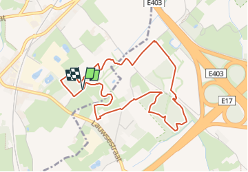
Tour Zu Fuß von 4,5 km verfügbar auf Flandern, Westflandern, Menen. Diese Tour wird von SityTrail - itinéraires balisés pédestres vorgeschlagen.
Beschreibung
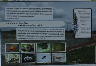
Trail created by Agentschap natuur @ bos.
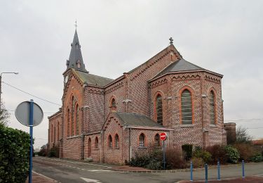
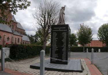
symbool zelfde indien geen tekst erbij lijkt op Markebeekpad
Ort
Land:
Belgium
Region :
Flandern
Abteilung/Provinz :
Westflandern
Kommune :
Menen
Standort:
Lauwe
Gehen Sie:(Dec)
Gehen Sie:(UTM)
514872 ; 5626415 (31U) N.
Kommentare
Touren in der Umgebung
![Tour Zu Fuß Kortrijk - Markebeekpad - Photo](https://media.geolcdn.com/t/375/260/ext.jpg?maxdim=2&url=https%3A%2F%2Fmedia.geolcdn.com%2Ff%2Fe7c7bf34-88a3-4b33-97ab-5fbbd87b7c1d.jpeg)
![Zu Fuß Zu Fuß](https://static1.geolcdn.com/sitytour/trail-icons/100.png)
Markebeekpad
Zu Fuß
Einfach
Kortrijk,
Flandern,
Westflandern,
Belgium
![](/images/other/stat-length.png)
4,3 km | 5 km-effort
1h 8min
![](https://static1.geolcdn.com/siteimages/upload/files/16400158638029165_repeat_loop_refresh_sync_direction_icon.png)
Ja
![Tour Zu Fuß Kortrijk - Twee bekenwandelroute - Photo](https://media.geolcdn.com/t/375/260/ext.jpg?maxdim=2&url=https%3A%2F%2Fmedia.geolcdn.com%2Ff%2F5c28fb18-5c25-4c5d-9d3f-100b9d27b980.jpeg)
![Zu Fuß Zu Fuß](https://static1.geolcdn.com/sitytour/trail-icons/100.png)
Twee bekenwandelroute
Zu Fuß
Einfach
Kortrijk,
Flandern,
Westflandern,
Belgium
![](/images/other/stat-length.png)
12,2 km | 13,3 km-effort
3h 1min
![](https://static1.geolcdn.com/siteimages/upload/files/16400158638029165_repeat_loop_refresh_sync_direction_icon.png)
Ja
![Tour Zu Fuß Kortrijk - Stadswandelroute Kortrijk - Photo](https://media.geolcdn.com/t/375/260/ext.jpg?maxdim=2&url=https%3A%2F%2Fmedia.geolcdn.com%2Ff%2F4fdb58de-2377-4d35-839b-35b6b751a901.jpeg)
![Zu Fuß Zu Fuß](https://static1.geolcdn.com/sitytour/trail-icons/100.png)
Stadswandelroute Kortrijk
Zu Fuß
Einfach
Kortrijk,
Flandern,
Westflandern,
Belgium
![](/images/other/stat-length.png)
4,5 km | 4,8 km-effort
1h 5min
![](https://static1.geolcdn.com/siteimages/upload/files/16400158638029165_repeat_loop_refresh_sync_direction_icon.png)
Ja
![Tour Zu Fuß Menen - Smokkelaarspad - Photo](https://media.geolcdn.com/t/375/260/ext.jpg?maxdim=2&url=https%3A%2F%2Fmedia.geolcdn.com%2Ff%2Fdfeb53ad-0f3e-45a5-b15b-6104366d05fc.jpeg)
![Zu Fuß Zu Fuß](https://static1.geolcdn.com/sitytour/trail-icons/100.png)
Smokkelaarspad
Zu Fuß
Einfach
Menen,
Flandern,
Westflandern,
Belgium
![](/images/other/stat-length.png)
10,3 km | 11,2 km-effort
2h 32min
![](https://static1.geolcdn.com/siteimages/upload/files/16400158638029165_repeat_loop_refresh_sync_direction_icon.png)
Ja
![Tour Zu Fuß Menen - Kortewagenpad Lauwe - Photo](https://media.geolcdn.com/t/375/260/ext.jpg?maxdim=2&url=https%3A%2F%2Fmedia.geolcdn.com%2Ff%2Ff545b169-9dc5-48d6-bcd5-5fdbffb4f316.jpeg)
![Zu Fuß Zu Fuß](https://static1.geolcdn.com/sitytour/trail-icons/100.png)
Kortewagenpad Lauwe
Zu Fuß
Einfach
Menen,
Flandern,
Westflandern,
Belgium
![](/images/other/stat-length.png)
13 km | 14,4 km-effort
3h 16min
![](https://static1.geolcdn.com/siteimages/upload/files/16400158638029165_repeat_loop_refresh_sync_direction_icon.png)
Ja
![Tour Wandern Menen - DKP2013 - Photo](https://media.geolcdn.com/t/375/260/ext.jpg?maxdim=2&url=https%3A%2F%2Fstatic1.geolcdn.com%2Fsiteimages%2Fupload%2Ffiles%2F1553511878bg_sport_marche.png)
![Wandern Wandern](https://static1.geolcdn.com/sitytour/trail-icons/101.png)
DKP2013
Wandern
Sehr leicht
(3)
Menen,
Flandern,
Westflandern,
Belgium
![](/images/other/stat-length.png)
7,7 km | 8,4 km-effort
1h 38min
![](https://static1.geolcdn.com/siteimages/upload/files/16400158638029165_repeat_loop_refresh_sync_direction_icon.png)
Nein
![Tour Wandern Mouscron - Milpattes - 04032013 - Photo](https://media.geolcdn.com/t/375/260/ext.jpg?maxdim=2&url=https%3A%2F%2Fservices.sitytrail.com%2FGeolivesWS%2FDownloadMedia.ashx%3FTrailID%3D178129%26Media%3Dd3a50fea-3fcb-4a33-88e2-cc91e0676007.JPG)
![Wandern Wandern](https://static1.geolcdn.com/sitytour/trail-icons/101.png)
Milpattes - 04032013
Wandern
Medium
Mouscron,
Wallonien,
Hennegau,
Belgium
![](/images/other/stat-length.png)
8,5 km | 9,4 km-effort
2h 6min
![](https://static1.geolcdn.com/siteimages/upload/files/16400158638029165_repeat_loop_refresh_sync_direction_icon.png)
Ja
![Tour Wandern Mouscron - Milpattes - 21012013 - Photo](https://media.geolcdn.com/t/375/260/ext.jpg?maxdim=2&url=https%3A%2F%2Fservices.sitytrail.com%2FGeolivesWS%2FDownloadMedia.ashx%3FTrailID%3D177547%26Media%3Da7417999-4fc1-43d3-88c3-3df18a4067b6.JPG)
![Wandern Wandern](https://static1.geolcdn.com/sitytour/trail-icons/101.png)
Milpattes - 21012013
Wandern
Einfach
Mouscron,
Wallonien,
Hennegau,
Belgium
![](/images/other/stat-length.png)
6 km | 6,7 km-effort
1h 28min
![](https://static1.geolcdn.com/siteimages/upload/files/16400158638029165_repeat_loop_refresh_sync_direction_icon.png)
Ja
![Tour Wandern Halluin - Boucle de la fraude du tabac - Halluin - Photo](https://media.geolcdn.com/t/375/260/ext.jpg?maxdim=2&url=https%3A%2F%2Fservices.sitytrail.com%2FGeolivesWS%2FDownloadMedia.ashx%3FTrailID%3D109277%26Media%3D3398_6.jpg)
![Wandern Wandern](https://static1.geolcdn.com/sitytour/trail-icons/101.png)
Boucle de la fraude du tabac - Halluin
Wandern
Medium
(2)
Halluin,
Nordfrankreich,
Nord,
France
![](/images/other/stat-length.png)
9,3 km | 10,1 km-effort
2h 19min
![](https://static1.geolcdn.com/siteimages/upload/files/16400158638029165_repeat_loop_refresh_sync_direction_icon.png)
Ja