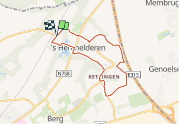
![](/images/other/stat-length.png)
![Tour Zu Fuß Tongern - 's Herenelderen - Photo](https://media.geolcdn.com/t/1900/400/5ab8c445-6053-4792-93e2-8364cf86f17e.jpeg&format=pjpeg&maxdim=2)
's Herenelderen
SityTrail - itinéraires balisés pédestres
Tous les sentiers balisés d’Europe GUIDE+
![Länge](/images/other/stat-length.png)
Länge
6,5 km
![Maximale Höhe](https://static1.geolcdn.com/siteimages/upload/files/1508320355ic_sort_altitude_max_24dp.png)
Maximale Höhe
98 m
![Positive Höhendifferenz](https://static1.geolcdn.com/siteimages/upload/files/1508320355ic_sort_den_pos_24dp.png)
Positive Höhendifferenz
60 m
![Km-Effort](/images/other/stat-length.png)
Km-Effort
7,3 km
![Min. Höhe](https://static1.geolcdn.com/siteimages/upload/files/1508320355ic_sort_altitude_min_24dp.png)
Min. Höhe
72 m
![Negative Höhendifferenz](https://static1.geolcdn.com/siteimages/upload/files/1508320355ic_sort_den_neg_24dp.png)
Negative Höhendifferenz
60 m
![Boucle](https://static1.geolcdn.com/siteimages/upload/files/16400158638029165_repeat_loop_refresh_sync_direction_icon.png)
Boucle
Ja
Kennzeichnung
Erstellungsdatum :
2022-02-09 19:19:48.031
Letzte Änderung :
2022-02-09 19:19:48.031
![Zu Fuß](https://static1.geolcdn.com/sitytour/trail-icons/100.png)
1h39
Schwierigkeit : Einfach
![Scannen Sie diesen QR-Code, um die Tour in der SityTrail-Anwendung zu öffnen](https://capi.geolives.com/qq0zvz2zws4bq2lad0pu/sitytour/trails/3085315/qr.png?size=200)
Kostenlosegpshiking-Anwendung
Über SityTrail
Tour Zu Fuß von 6,5 km verfügbar auf Flandern, Limburg, Tongern. Diese Tour wird von SityTrail - itinéraires balisés pédestres vorgeschlagen.
Beschreibung
Trail created by Stad Tongeren.
Symbol: triangle
Ort
Land:
Belgium
Region :
Flandern
Abteilung/Provinz :
Limburg
Kommune :
Tongern
Standort:
's Herenelderen
Gehen Sie:(Dec)
Gehen Sie:(UTM)
675838 ; 5631542 (31U) N.
Kommentare
Touren in der Umgebung
![Tour Wandern Tongern - Tongres - Photo](https://media.geolcdn.com/t/375/260/e6784500-8094-4a7e-b3d4-8606bc9495c2.jpg&format=jpg&maxdim=2)
![Wandern Wandern](https://static1.geolcdn.com/sitytour/trail-icons/101.png)
![Tour Zu Fuß Tongern - Molsterbos - Photo](https://media.geolcdn.com/t/375/260/3c500f4e-d8ab-4470-8eed-45fbfc940cd4.jpeg&format=jpg&maxdim=2)
![Zu Fuß Zu Fuß](https://static1.geolcdn.com/sitytour/trail-icons/100.png)
![Tour Zu Fuß Riemst - Millen Rode pijl - Photo](https://media.geolcdn.com/t/375/260/e13dc116-bc9c-4888-8587-6c9490baf591.jpeg&format=jpg&maxdim=2)
![Zu Fuß Zu Fuß](https://static1.geolcdn.com/sitytour/trail-icons/100.png)
![Tour Zu Fuß Tongern - Mal - Photo](https://media.geolcdn.com/t/375/260/73ec92f8-b6f9-4e9a-8736-49b1be80c469.jpeg&format=jpg&maxdim=2)
![Zu Fuß Zu Fuß](https://static1.geolcdn.com/sitytour/trail-icons/100.png)
![Tour Zu Fuß Bilzen - Alden Biesen Groene rechthoek - Photo](https://media.geolcdn.com/t/375/260/15e1303f-03e7-49b9-9b8a-d22ed4d8a521.jpeg&format=jpg&maxdim=2)
![Zu Fuß Zu Fuß](https://static1.geolcdn.com/sitytour/trail-icons/100.png)
Alden Biesen Groene rechthoek
Zu Fuß
Einfach
Bilzen,
Flandern,
Limburg,
Belgium
![](/images/other/stat-length.png)
4,6 km | 5,3 km-effort
1h 12min
![](https://static1.geolcdn.com/siteimages/upload/files/16400158638029165_repeat_loop_refresh_sync_direction_icon.png)
Ja
![Tour Zu Fuß Tongern - Evermaruspad - Photo](https://media.geolcdn.com/t/375/260/f7674873-62f0-49d5-a77c-72417cfbbe5a.jpeg&format=jpg&maxdim=2)
![Zu Fuß Zu Fuß](https://static1.geolcdn.com/sitytour/trail-icons/100.png)
Evermaruspad
Zu Fuß
Einfach
(1)
Tongern,
Flandern,
Limburg,
Belgium
![](/images/other/stat-length.png)
10,1 km | 11 km-effort
2h 30min
![](https://static1.geolcdn.com/siteimages/upload/files/16400158638029165_repeat_loop_refresh_sync_direction_icon.png)
Ja
![Tour Zu Fuß Hoeselt - Tweekruizenwandeling gele zeshoek - Photo](https://media.geolcdn.com/t/375/260/2653ece4-549d-4211-a1fa-9bd3ba924b80.jpeg&format=jpg&maxdim=2)
![Zu Fuß Zu Fuß](https://static1.geolcdn.com/sitytour/trail-icons/100.png)
Tweekruizenwandeling gele zeshoek
Zu Fuß
Einfach
Hoeselt,
Flandern,
Limburg,
Belgium
![](/images/other/stat-length.png)
8,5 km | 9,6 km-effort
2h 11min
![](https://static1.geolcdn.com/siteimages/upload/files/16400158638029165_repeat_loop_refresh_sync_direction_icon.png)
Ja
![Tour Zu Fuß Tongern - Kolment Zwart - Photo](https://media.geolcdn.com/t/375/260/c7edafc2-5156-487c-b4e6-8b3b09a5b390.jpeg&format=jpg&maxdim=2)
![Zu Fuß Zu Fuß](https://static1.geolcdn.com/sitytour/trail-icons/100.png)
![Tour Zu Fuß Tongern - Berg Rode pijl - Photo](https://media.geolcdn.com/t/375/260/be692f14-fbf1-4cc4-ae8e-8d1bd88e85b0.jpeg&format=jpg&maxdim=2)
![Zu Fuß Zu Fuß](https://static1.geolcdn.com/sitytour/trail-icons/100.png)
Berg Rode pijl
Zu Fuß
Einfach
(1)
Tongern,
Flandern,
Limburg,
Belgium
![](/images/other/stat-length.png)
6,2 km | 7,3 km-effort
1h 40min
![](https://static1.geolcdn.com/siteimages/upload/files/16400158638029165_repeat_loop_refresh_sync_direction_icon.png)
Ja