![](/images/other/stat-length.png)
![Tour Zu Fuß Esch an der Alzette - Sentier Pierre Wiess - Photo](https://media.geolcdn.com/t/1900/400/fb7503a0-8edc-4589-a05b-6ac952d1b3b6.jpeg&format=pjpeg&maxdim=2)
Sentier Pierre Wiess
SityTrail - itinéraires balisés pédestres
Tous les sentiers balisés d’Europe GUIDE+
![Länge](/images/other/stat-length.png)
Länge
3,9 km
![Maximale Höhe](https://static1.geolcdn.com/siteimages/upload/files/1508320355ic_sort_altitude_max_24dp.png)
Maximale Höhe
433 m
![Positive Höhendifferenz](https://static1.geolcdn.com/siteimages/upload/files/1508320355ic_sort_den_pos_24dp.png)
Positive Höhendifferenz
140 m
![Km-Effort](/images/other/stat-length.png)
Km-Effort
5,4 km
![Min. Höhe](https://static1.geolcdn.com/siteimages/upload/files/1508320355ic_sort_altitude_min_24dp.png)
Min. Höhe
316 m
![Negative Höhendifferenz](https://static1.geolcdn.com/siteimages/upload/files/1508320355ic_sort_den_neg_24dp.png)
Negative Höhendifferenz
34 m
![Boucle](https://static1.geolcdn.com/siteimages/upload/files/16400158638029165_repeat_loop_refresh_sync_direction_icon.png)
Boucle
Nein
Kennzeichnung
Erstellungsdatum :
2022-02-09 18:55:29.869
Letzte Änderung :
2022-03-10 10:16:44.184
![Zu Fuß](https://static1.geolcdn.com/sitytour/trail-icons/100.png)
1h14
Schwierigkeit : Einfach
![Scannen Sie diesen QR-Code, um die Tour in der SityTrail-Anwendung zu öffnen](https://capi.geolives.com/qq0zvz2zws4bq2lad0pu/sitytour/trails/3084922/qr.png?size=200)
Kostenlosegpshiking-Anwendung
Über SityTrail
Tour Zu Fuß von 3,9 km verfügbar auf Unbekannt, Kanton Esch an der Alzette, Esch an der Alzette. Diese Tour wird von SityTrail - itinéraires balisés pédestres vorgeschlagen.
Beschreibung
Ort
Land:
Luxembourg
Region :
Unbekannt
Abteilung/Provinz :
Kanton Esch an der Alzette
Kommune :
Esch an der Alzette
Standort:
Park
Gehen Sie:(Dec)
Gehen Sie:(UTM)
715970 ; 5484733 (31U) N.
Kommentare
Touren in der Umgebung
![Tour Zu Fuß Schifflingen - Auto-Pédestre Schifflange - Photo](https://media.geolcdn.com/t/375/260/6e4f4de8-0f99-4558-801f-ac0feb96d3b3.jpeg&format=jpg&maxdim=2)
![Zu Fuß Zu Fuß](https://static1.geolcdn.com/sitytour/trail-icons/100.png)
Auto-Pédestre Schifflange
Zu Fuß
Einfach
Schifflingen,
Unbekannt,
Kanton Esch an der Alzette,
Luxembourg
![](/images/other/stat-length.png)
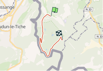
7,8 km | 10,5 km-effort
2h 23min
![](https://static1.geolcdn.com/siteimages/upload/files/16400158638029165_repeat_loop_refresh_sync_direction_icon.png)
Ja
![Tour Zu Fuß Esch an der Alzette - Auto-Pédestre Esch-sur-Alzette - Photo](https://media.geolcdn.com/t/375/260/b5c02b78-1f2a-4286-8a45-2a22bbfe4d56.jpeg&format=jpg&maxdim=2)
![Zu Fuß Zu Fuß](https://static1.geolcdn.com/sitytour/trail-icons/100.png)
Auto-Pédestre Esch-sur-Alzette
Zu Fuß
Einfach
(1)
Esch an der Alzette,
Unbekannt,
Kanton Esch an der Alzette,
Luxembourg
![](/images/other/stat-length.png)
7,2 km | 9,8 km-effort
2h 13min
![](https://static1.geolcdn.com/siteimages/upload/files/16400158638029165_repeat_loop_refresh_sync_direction_icon.png)
Ja
![Tour Zu Fuß Kayl - Auto-Pédestre Kayl - Photo](https://media.geolcdn.com/t/375/260/05634cbd-69a7-4685-a005-dc48af1d3e5c.jpeg&format=jpg&maxdim=2)
![Zu Fuß Zu Fuß](https://static1.geolcdn.com/sitytour/trail-icons/100.png)
Auto-Pédestre Kayl
Zu Fuß
Einfach
Kayl,
Unbekannt,
Kanton Esch an der Alzette,
Luxembourg
![](/images/other/stat-length.png)
5,9 km | 7,6 km-effort
1h 43min
![](https://static1.geolcdn.com/siteimages/upload/files/16400158638029165_repeat_loop_refresh_sync_direction_icon.png)
Ja
![Tour Mountainbike Deutsch-Oth - la randodunoise 2010 - Photo](https://media.geolcdn.com/t/375/260/ext.jpg?maxdim=2&url=https%3A%2F%2Fstatic1.geolcdn.com%2Fsiteimages%2Fupload%2Ffiles%2F1524743154velo.jpg)
![Mountainbike Mountainbike](https://static1.geolcdn.com/sitytour/trail-icons/202.png)
la randodunoise 2010
Mountainbike
Sehr leicht
(1)
Deutsch-Oth,
Großer Osten,
Mosel,
France
![](/images/other/stat-length.png)
38 km | 48 km-effort
Unbekannt
![](https://static1.geolcdn.com/siteimages/upload/files/16400158638029165_repeat_loop_refresh_sync_direction_icon.png)
Nein
![Tour Zu Fuß Öttingen - Boucle d'Ottange - Photo](https://media.geolcdn.com/t/375/260/4f81de2e-9288-4ceb-9209-2e12554d6d66.jpeg&format=jpg&maxdim=2)
![Zu Fuß Zu Fuß](https://static1.geolcdn.com/sitytour/trail-icons/100.png)
Boucle d'Ottange
Zu Fuß
Einfach
Öttingen,
Großer Osten,
Mosel,
France
![](/images/other/stat-length.png)
4,1 km | 5,5 km-effort
1h 14min
![](https://static1.geolcdn.com/siteimages/upload/files/16400158638029165_repeat_loop_refresh_sync_direction_icon.png)
Ja
![Tour Zu Fuß Redingen - Boucle de Rédange - Photo](https://media.geolcdn.com/t/375/260/f050ebd0-ef73-4e7b-9c2b-78da25f4d2eb.jpeg&format=jpg&maxdim=2)
![Zu Fuß Zu Fuß](https://static1.geolcdn.com/sitytour/trail-icons/100.png)
Boucle de Rédange
Zu Fuß
Einfach
Redingen,
Großer Osten,
Mosel,
France
![](/images/other/stat-length.png)
4,6 km | 5,4 km-effort
1h 14min
![](https://static1.geolcdn.com/siteimages/upload/files/16400158638029165_repeat_loop_refresh_sync_direction_icon.png)
Nein
![Tour Zu Fuß Öttingen - Ottange Circuit Schmettebusch - Photo](https://media.geolcdn.com/t/375/260/e03ec25f-1ced-4014-8b11-d9cfd2f098ff.jpeg&format=jpg&maxdim=2)
![Zu Fuß Zu Fuß](https://static1.geolcdn.com/sitytour/trail-icons/100.png)
Ottange Circuit Schmettebusch
Zu Fuß
Einfach
Öttingen,
Großer Osten,
Mosel,
France
![](/images/other/stat-length.png)
5,7 km | 7,9 km-effort
1h 47min
![](https://static1.geolcdn.com/siteimages/upload/files/16400158638029165_repeat_loop_refresh_sync_direction_icon.png)
Nein
![Tour Zu Fuß Kayl - Circuit Tétange - Photo](https://media.geolcdn.com/t/375/260/7753739c-30dc-49db-8d8b-fb1244e1177a.jpeg&format=jpg&maxdim=2)
![Zu Fuß Zu Fuß](https://static1.geolcdn.com/sitytour/trail-icons/100.png)
Circuit Tétange
Zu Fuß
Einfach
Kayl,
Unbekannt,
Kanton Esch an der Alzette,
Luxembourg
![](/images/other/stat-length.png)
7,1 km | 8,8 km-effort
1h 59min
![](https://static1.geolcdn.com/siteimages/upload/files/16400158638029165_repeat_loop_refresh_sync_direction_icon.png)
Nein
![Tour Zu Fuß Esch an der Alzette - Promenade Architecturale - Photo](https://media.geolcdn.com/t/375/260/fc1c5986-5145-4464-8347-1dd156f13990.jpeg&format=jpg&maxdim=2)
![Zu Fuß Zu Fuß](https://static1.geolcdn.com/sitytour/trail-icons/100.png)
Promenade Architecturale
Zu Fuß
Einfach
Esch an der Alzette,
Unbekannt,
Kanton Esch an der Alzette,
Luxembourg
![](/images/other/stat-length.png)
4 km | 4,3 km-effort
58min
![](https://static1.geolcdn.com/siteimages/upload/files/16400158638029165_repeat_loop_refresh_sync_direction_icon.png)
Ja