![](/images/other/stat-length.png)
![Tour Zu Fuß Ouffet - Wanderung der Wölfe - Photo](https://media.geolcdn.com/t/1900/400/ext.pjpeg?maxdim=2&url=https%3A%2F%2Fpivotmedia.tourismewallonie.be%2FANX-0W-000PC3%2FANX-0W-000PC3.jpg)
Wanderung der Wölfe
Commissariat général au Tourisme
Randonnées du CGT GUIDE+
![Länge](/images/other/stat-length.png)
![Maximale Höhe](https://static1.geolcdn.com/siteimages/upload/files/1508320355ic_sort_altitude_max_24dp.png)
![Positive Höhendifferenz](https://static1.geolcdn.com/siteimages/upload/files/1508320355ic_sort_den_pos_24dp.png)
![Km-Effort](/images/other/stat-length.png)
![Min. Höhe](https://static1.geolcdn.com/siteimages/upload/files/1508320355ic_sort_altitude_min_24dp.png)
![Negative Höhendifferenz](https://static1.geolcdn.com/siteimages/upload/files/1508320355ic_sort_den_neg_24dp.png)
![Boucle](https://static1.geolcdn.com/siteimages/upload/files/16400158638029165_repeat_loop_refresh_sync_direction_icon.png)
![Zu Fuß](https://static1.geolcdn.com/sitytour/trail-icons/100.png)
3h05
Schwierigkeit : Einfach
![Mountainbike](https://static1.geolcdn.com/sitytour/trail-icons/202.png)
56m
Schwierigkeit : Einfach
![Scannen Sie diesen QR-Code, um die Tour in der SityTrail-Anwendung zu öffnen](https://capi.geolives.com/qq0zvz2zws4bq2lad0pu/sitytour/trails/3081498/qr.png?size=200)
Kostenlosegpshiking-Anwendung
Über SityTrail
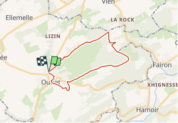
Tour Zu Fuß von 11,5 km verfügbar auf Wallonien, Lüttich, Ouffet. Diese Tour wird von Commissariat général au Tourisme vorgeschlagen.
Beschreibung
Trail created by Ourthe Vesdre Amblève.
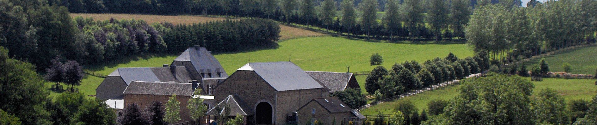
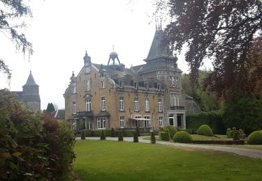
Diese Wanderung beginnt im Zentrum von Ouffet und führt zunächst zu einem bemerkenswerten Gebäude der Gemeinde: der ehemalige Gerichtshof, der mehrfach umgebaut und renoviert wurde. Weiter geht es in Richtung Petit Ouffet, Tige de Fairon und Odeigne, wo man ein schönes Bauernhaus aus dem 17. Jahrhundert bewundern kannchaft. Folgen Sie dem Waldrand von Houp-le-Loup und Sie stossen auf ein wunderschön renoviertes Bauernhaus. Der Weg geht dann durch den Wald in Richtung Norden bis zur alten Eisenbahnlinie entlang des Troïdo-Steinbruchs, weiter zur Eiche "Brihî Tiyou" und dann zurück zum Ausgangspunkt.
Ort
Kommentare
Touren in der Umgebung
![Tour Wandern Anthisnes - Anthines - AS03 - Boucle de Tolumont - Losange Bleu - Photo](https://media.geolcdn.com/t/375/260/a3413dfd-3361-4d9b-b91d-7efec18943a3.jpg&format=jpg&maxdim=2)
![Wandern Wandern](https://static1.geolcdn.com/sitytour/trail-icons/101.png)
Wandern
![](/images/other/stat-length.png)
![](https://static1.geolcdn.com/siteimages/upload/files/16400158638029165_repeat_loop_refresh_sync_direction_icon.png)
![Tour Wandern Hamoir - HAMOIR (Vallée du Neblon) - Photo](https://media.geolcdn.com/t/375/260/bd133f9f-5595-47e8-88c0-4d09e83d3ba8.jpg&format=jpg&maxdim=2)
![Wandern Wandern](https://static1.geolcdn.com/sitytour/trail-icons/101.png)
Wandern
![](/images/other/stat-length.png)
![](https://static1.geolcdn.com/siteimages/upload/files/16400158638029165_repeat_loop_refresh_sync_direction_icon.png)
![Tour Zu Fuß Anthisnes - AS03 Boucle de Tolumont - Photo](https://media.geolcdn.com/t/375/260/bb3be3cf-eddc-4622-8273-ff9944f2671c.jpg&format=jpg&maxdim=2)
![Zu Fuß Zu Fuß](https://static1.geolcdn.com/sitytour/trail-icons/100.png)
Zu Fuß
![](/images/other/stat-length.png)
![](https://static1.geolcdn.com/siteimages/upload/files/16400158638029165_repeat_loop_refresh_sync_direction_icon.png)
![Tour Wandern Ferrières - GG-Lu-15_Sy - Barvaux - Photo](https://media.geolcdn.com/t/375/260/4cf6fb9a-77d5-4c51-bb72-4b6ca6a27202.jpg&format=jpg&maxdim=2)
![Wandern Wandern](https://static1.geolcdn.com/sitytour/trail-icons/101.png)
Wandern
![](/images/other/stat-length.png)
![](https://static1.geolcdn.com/siteimages/upload/files/16400158638029165_repeat_loop_refresh_sync_direction_icon.png)
![Tour Wandern Anthisnes - Hody . drive d Anthisnes . carrière . Targnon . Hestreux . Fond de Sart . Hody - Photo](https://media.geolcdn.com/t/375/260/ac4de494-7be1-46d6-92d3-c5a298377ce3.jpg&format=jpg&maxdim=2)
![Wandern Wandern](https://static1.geolcdn.com/sitytour/trail-icons/101.png)
Wandern
![](/images/other/stat-length.png)
![](https://static1.geolcdn.com/siteimages/upload/files/16400158638029165_repeat_loop_refresh_sync_direction_icon.png)
![Wandern Wandern](https://static1.geolcdn.com/sitytour/trail-icons/101.png)
![Tour Wandern Ouffet - ouffet fermes ac + - Photo](https://media.geolcdn.com/t/375/260/fd6ab0a5-da2e-4ec4-9fa1-96c42c21280a.jpg&format=jpg&maxdim=2)
![Wandern Wandern](https://static1.geolcdn.com/sitytour/trail-icons/101.png)
Wandern
![](/images/other/stat-length.png)
![](https://static1.geolcdn.com/siteimages/upload/files/16400158638029165_repeat_loop_refresh_sync_direction_icon.png)
![Tour Wandern Hamoir - Hamoir adepstr - Photo](https://media.geolcdn.com/t/375/260/f7c6aedd-db0e-4e45-9994-a9f8bea87367.jpg&format=jpg&maxdim=2)
![Wandern Wandern](https://static1.geolcdn.com/sitytour/trail-icons/101.png)
Wandern
![](/images/other/stat-length.png)
![](https://static1.geolcdn.com/siteimages/upload/files/16400158638029165_repeat_loop_refresh_sync_direction_icon.png)
![Tour Wandern Anthisnes - départ du château de l'Avouerie d'Anthisnes - Photo](https://media.geolcdn.com/t/375/260/ext.jpg?maxdim=2&url=https%3A%2F%2Fservices.sitytrail.com%2FGeolivesWS%2FDownloadMedia.ashx%3FTrailID%3D688091%26Media%3D20170122160059.jpg)
![Wandern Wandern](https://static1.geolcdn.com/sitytour/trail-icons/101.png)
Wandern
![](/images/other/stat-length.png)
![](https://static1.geolcdn.com/siteimages/upload/files/16400158638029165_repeat_loop_refresh_sync_direction_icon.png)