![](/images/other/stat-length.png)
![Tour Hybrid-Bike La Louvière - La Grande Boucle - Photo](https://media.geolcdn.com/t/1900/400/ext.pjpeg?maxdim=2&url=https%3A%2F%2Fpivotmedia.tourismewallonie.be%2FOTH-A0-004V-05JZ%2FOTH-A0-004V-05JZ.jpg)
La Grande Boucle
Commissariat général au Tourisme
Randonnées du CGT GUIDE+
![Länge](/images/other/stat-length.png)
Länge
29 km
![Maximale Höhe](https://static1.geolcdn.com/siteimages/upload/files/1508320355ic_sort_altitude_max_24dp.png)
Maximale Höhe
134 m
![Positive Höhendifferenz](https://static1.geolcdn.com/siteimages/upload/files/1508320355ic_sort_den_pos_24dp.png)
Positive Höhendifferenz
341 m
![Km-Effort](/images/other/stat-length.png)
Km-Effort
33 km
![Min. Höhe](https://static1.geolcdn.com/siteimages/upload/files/1508320355ic_sort_altitude_min_24dp.png)
Min. Höhe
46 m
![Negative Höhendifferenz](https://static1.geolcdn.com/siteimages/upload/files/1508320355ic_sort_den_neg_24dp.png)
Negative Höhendifferenz
342 m
![Boucle](https://static1.geolcdn.com/siteimages/upload/files/16400158638029165_repeat_loop_refresh_sync_direction_icon.png)
Boucle
Ja
Erstellungsdatum :
2022-02-08 11:29:20.441
Letzte Änderung :
2022-02-21 10:10:42.516
![Hybrid-Bike](https://static1.geolcdn.com/sitytour/trail-icons/203.png)
--
Schwierigkeit : Schwierig
![Scannen Sie diesen QR-Code, um die Tour in der SityTrail-Anwendung zu öffnen](https://capi.geolives.com/qq0zvz2zws4bq2lad0pu/sitytour/trails/3080835/qr.png?size=200)
Kostenlosegpshiking-Anwendung
Über SityTrail
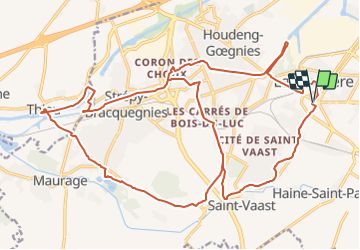
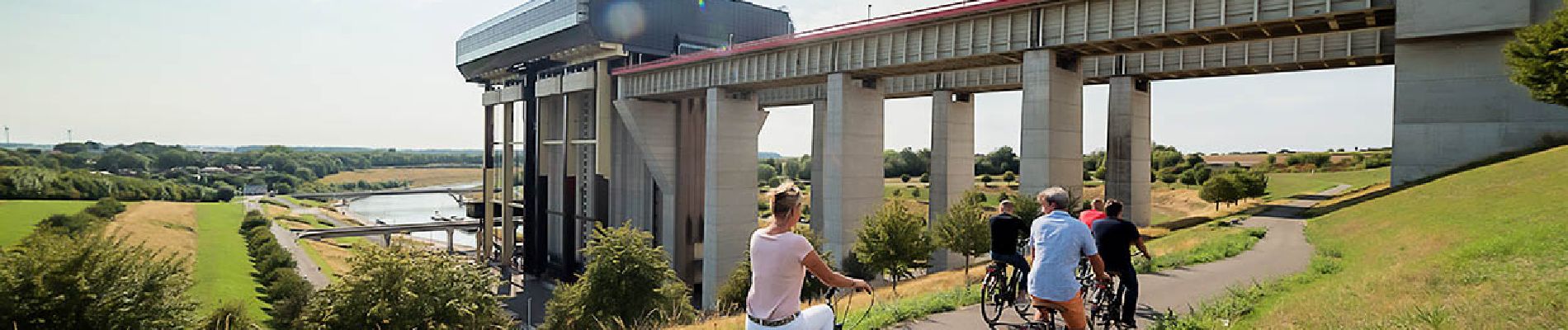
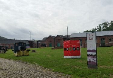
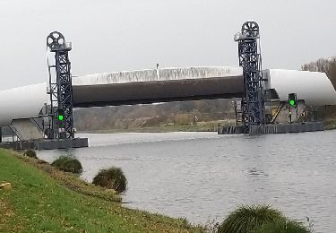
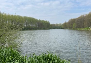
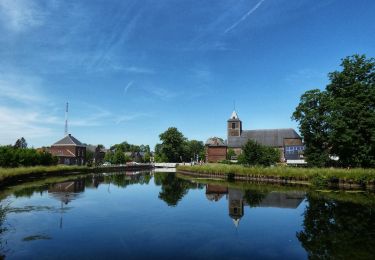
Tour Hybrid-Bike von 29 km verfügbar auf Wallonien, Hennegau, La Louvière. Diese Tour wird von Commissariat général au Tourisme vorgeschlagen.
Beschreibung
Trail created by Parc des Canaux et Châteaux.
Ort
Land:
Belgium
Region :
Wallonien
Abteilung/Provinz :
Hennegau
Kommune :
La Louvière
Standort:
La Louvière (section)
Gehen Sie:(Dec)
Gehen Sie:(UTM)
584091 ; 5592104 (31U) N.
Kommentare
Touren in der Umgebung
![Tour Wandern Morlanwelz - Le circuit des 3 villages - Morlanwelz - Photo](https://media.geolcdn.com/t/375/260/ext.jpg?maxdim=2&url=https%3A%2F%2Fservices.sitytrail.com%2FGeolivesWS%2FDownloadMedia.ashx%3FTrailID%3D359319%26Media%3Dc0e82042-2414-44e3-b558-69c50177e9e8.JPG)
![Wandern Wandern](https://static1.geolcdn.com/sitytour/trail-icons/101.png)
Le circuit des 3 villages - Morlanwelz
Wandern
Sehr leicht
(4)
Morlanwelz,
Wallonien,
Hennegau,
Belgium
![](/images/other/stat-length.png)
7,9 km | 9,6 km-effort
2h 6min
![](https://static1.geolcdn.com/siteimages/upload/files/16400158638029165_repeat_loop_refresh_sync_direction_icon.png)
Ja
![Tour Wandern Morlanwelz - Balade dans le Parc et le Bois de Mariemont - Photo](https://media.geolcdn.com/t/375/260/ext.jpg?maxdim=2&url=https%3A%2F%2Fservices.sitytrail.com%2FGeolivesWS%2FDownloadMedia.ashx%3FTrailID%3D194631%26Media%3D8d7b7fc5-39c0-42de-b5bd-02b875ee162a.JPG)
![Wandern Wandern](https://static1.geolcdn.com/sitytour/trail-icons/101.png)
Balade dans le Parc et le Bois de Mariemont
Wandern
Sehr leicht
(3)
Morlanwelz,
Wallonien,
Hennegau,
Belgium
![](/images/other/stat-length.png)
6,4 km | 8,2 km-effort
1h 45min
![](https://static1.geolcdn.com/siteimages/upload/files/16400158638029165_repeat_loop_refresh_sync_direction_icon.png)
Ja
![Tour Fahrrad La Louvière - Cantine des Italiens-Canal du centre-Bois du Luc - Photo](https://media.geolcdn.com/t/375/260/ext.jpg?maxdim=2&url=https%3A%2F%2Fservices.sitytrail.com%2FGeolivesWS%2FDownloadMedia.ashx%3FTrailID%3D797348%26Media%3Dfix__20170727115839.jpg)
![Fahrrad Fahrrad](https://static1.geolcdn.com/sitytour/trail-icons/200.png)
Cantine des Italiens-Canal du centre-Bois du Luc
Fahrrad
Einfach
(3)
La Louvière,
Wallonien,
Hennegau,
Belgium
![](/images/other/stat-length.png)
31 km | 35 km-effort
2h 1min
![](https://static1.geolcdn.com/siteimages/upload/files/16400158638029165_repeat_loop_refresh_sync_direction_icon.png)
Ja
![Tour Fahrrad La Louvière - Ascenseurs du Centre Strepy Thieu Bracquenies - Photo](https://media.geolcdn.com/t/375/260/ext.jpg?maxdim=2&url=https%3A%2F%2Fservices.sitytrail.com%2FGeolivesWS%2FDownloadMedia.ashx%3FTrailID%3D1074392%26Media%3Dfix__20181120130643.jpg)
![Fahrrad Fahrrad](https://static1.geolcdn.com/sitytour/trail-icons/200.png)
Ascenseurs du Centre Strepy Thieu Bracquenies
Fahrrad
Einfach
(1)
La Louvière,
Wallonien,
Hennegau,
Belgium
![](/images/other/stat-length.png)
18,5 km | 22 km-effort
3h 7min
![](https://static1.geolcdn.com/siteimages/upload/files/16400158638029165_repeat_loop_refresh_sync_direction_icon.png)
Ja
![Tour Wandern La Louvière - A la découverte du Canal du Centre - Houdeng Aimeries - Photo](https://media.geolcdn.com/t/375/260/ext.jpg?maxdim=2&url=https%3A%2F%2Fstatic1.geolcdn.com%2Fsiteimages%2Fupload%2Ffiles%2F1553511878bg_sport_marche.png)
![Wandern Wandern](https://static1.geolcdn.com/sitytour/trail-icons/101.png)
A la découverte du Canal du Centre - Houdeng Aimeries
Wandern
Einfach
(4)
La Louvière,
Wallonien,
Hennegau,
Belgium
![](/images/other/stat-length.png)
12,9 km | 15,4 km-effort
3h 0min
![](https://static1.geolcdn.com/siteimages/upload/files/16400158638029165_repeat_loop_refresh_sync_direction_icon.png)
Ja
![Tour Wandern Manage - Le Bois de Mariemont et la vallee de Scailmont - Photo](https://media.geolcdn.com/t/375/260/ext.jpg?maxdim=2&url=https%3A%2F%2Fstatic1.geolcdn.com%2Fsiteimages%2Fupload%2Ffiles%2F1553511878bg_sport_marche.png)
![Wandern Wandern](https://static1.geolcdn.com/sitytour/trail-icons/101.png)
Le Bois de Mariemont et la vallee de Scailmont
Wandern
Einfach
(3)
Manage,
Wallonien,
Hennegau,
Belgium
![](/images/other/stat-length.png)
11,9 km | 14,5 km-effort
3h 0min
![](https://static1.geolcdn.com/siteimages/upload/files/16400158638029165_repeat_loop_refresh_sync_direction_icon.png)
Ja
![Tour Nordic Walking Morlanwelz - SityTrail - 7 Km M st A Nov. 2023 - Photo](https://media.geolcdn.com/t/375/260/ext.jpg?maxdim=2&url=https%3A%2F%2Fstatic1.geolcdn.com%2Fsiteimages%2Fupload%2Ffiles%2F1545311037marcheuse_200dpi.jpg)
![Nordic Walking Nordic Walking](https://static1.geolcdn.com/sitytour/trail-icons/102.png)
SityTrail - 7 Km M st A Nov. 2023
Nordic Walking
Einfach
(1)
Morlanwelz,
Wallonien,
Hennegau,
Belgium
![](/images/other/stat-length.png)
7,1 km | 8,2 km-effort
1h 30min
![](https://static1.geolcdn.com/siteimages/upload/files/16400158638029165_repeat_loop_refresh_sync_direction_icon.png)
Ja
![Tour Wandern Le Rœulx - BE-Le Roeulx - La Haye du Roeulx - Domaine Aldo Vastapane - W - Photo](https://media.geolcdn.com/t/375/260/dd72392e-02a4-40c7-936e-9b75c105e7f1.jpg&format=jpg&maxdim=2)
![Wandern Wandern](https://static1.geolcdn.com/sitytour/trail-icons/101.png)
BE-Le Roeulx - La Haye du Roeulx - Domaine Aldo Vastapane - W
Wandern
Medium
Le Rœulx,
Wallonien,
Hennegau,
Belgium
![](/images/other/stat-length.png)
6,4 km | 7,5 km-effort
1h 41min
![](https://static1.geolcdn.com/siteimages/upload/files/16400158638029165_repeat_loop_refresh_sync_direction_icon.png)
Ja
![Tour Wandern La Louvière - La balade des ascenseurs - Houdeng-Aimeries - Photo](https://media.geolcdn.com/t/375/260/d99da6dd-7e06-432a-8742-a2cbb7aa82e8.jpeg&format=jpg&maxdim=2)
![Wandern Wandern](https://static1.geolcdn.com/sitytour/trail-icons/101.png)
La balade des ascenseurs - Houdeng-Aimeries
Wandern
Medium
La Louvière,
Wallonien,
Hennegau,
Belgium
![](/images/other/stat-length.png)
8 km | 9,1 km-effort
3h 42min
![](https://static1.geolcdn.com/siteimages/upload/files/16400158638029165_repeat_loop_refresh_sync_direction_icon.png)
Ja