![](/images/other/stat-length.png)
La centrale photovoltaique par le chemin de fer
ericberlin
Benutzer
![Länge](/images/other/stat-length.png)
![Maximale Höhe](https://static1.geolcdn.com/siteimages/upload/files/1508320355ic_sort_altitude_max_24dp.png)
![Positive Höhendifferenz](https://static1.geolcdn.com/siteimages/upload/files/1508320355ic_sort_den_pos_24dp.png)
![Km-Effort](/images/other/stat-length.png)
![Min. Höhe](https://static1.geolcdn.com/siteimages/upload/files/1508320355ic_sort_altitude_min_24dp.png)
![Negative Höhendifferenz](https://static1.geolcdn.com/siteimages/upload/files/1508320355ic_sort_den_neg_24dp.png)
![Boucle](https://static1.geolcdn.com/siteimages/upload/files/16400158638029165_repeat_loop_refresh_sync_direction_icon.png)
![Wandern](https://static1.geolcdn.com/sitytour/trail-icons/101.png)
2h52
Schwierigkeit : Schwierig
![Mountainbike](https://static1.geolcdn.com/sitytour/trail-icons/202.png)
52m
Schwierigkeit : Einfach
![Scannen Sie diesen QR-Code, um die Tour in der SityTrail-Anwendung zu öffnen](https://capi.geolives.com/qq0zvz2zws4bq2lad0pu/sitytour/trails/3072512/qr.png?size=200)
Kostenlosegpshiking-Anwendung
Über SityTrail
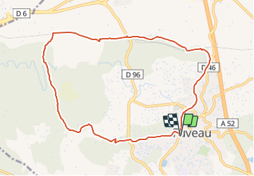
Tour Wandern von 10,1 km verfügbar auf Provence-Alpes-Côte d'Azur, Bouches-du-Rhône, Fuveau. Diese Tour wird von ericberlin vorgeschlagen.
Beschreibung
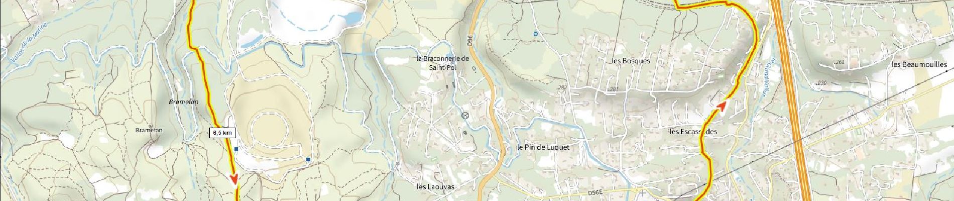
Départ halte routière de Fuveau. Passer l’école Roque Martine. Suivre l'ancienne voie ferrée Aubagne-Gardanne jusqu’au musée des transports, traverser la D96, longer la voie ferrée Trets-Gardanne suivre par le chemin de Bramefan le GR jusqu’au départ.
Pour info ce tour commence par l'ancienne gare de Fuveau détruite et devenue aujourd'hui la halte routière. Il emprunte plus ou moins l'ancienne voie ferrée qui allait de Aubagne à Gardanne. (partiellement convertie en voie verte sous le Moulin des Forges). Il passe par la gare désaffectée de la Barque où siège le musée des transports. Il revient par le GR Provence Energie qui passe par la centrale photovoltaïque de Bramefan.
sources:
Carte IGN 1950 https://remonterletemps.ign.fr/
https://urbasolar.com/references/terril-de-bramefan/https://fr.wikipedia.org/wiki/Ligne_d'Aubagne_à_La_Barque
https://fr.wikipedia.org/wiki/Ligne_de_Carnoules_à_Gardanne
http://jf-ber.roubaud.pagesperso-orange.fr/
https://www.mongr.fr/trouver-prochaine-randonnee/parcours/gr-de-pays-sentier-provence-mines-d-energies-petale-sud
Ort
Kommentare
Touren in der Umgebung
![Mountainbike Mountainbike](https://static1.geolcdn.com/sitytour/trail-icons/202.png)
Mountainbike
![](/images/other/stat-length.png)
![](https://static1.geolcdn.com/siteimages/upload/files/16400158638029165_repeat_loop_refresh_sync_direction_icon.png)
![Wandern Wandern](https://static1.geolcdn.com/sitytour/trail-icons/101.png)
Wandern
![](/images/other/stat-length.png)
![](https://static1.geolcdn.com/siteimages/upload/files/16400158638029165_repeat_loop_refresh_sync_direction_icon.png)
![Mountainbike Mountainbike](https://static1.geolcdn.com/sitytour/trail-icons/202.png)
Mountainbike
![](/images/other/stat-length.png)
![](https://static1.geolcdn.com/siteimages/upload/files/16400158638029165_repeat_loop_refresh_sync_direction_icon.png)
![Rennrad Rennrad](https://static1.geolcdn.com/sitytour/trail-icons/201.png)
Rennrad
![](/images/other/stat-length.png)
![](https://static1.geolcdn.com/siteimages/upload/files/16400158638029165_repeat_loop_refresh_sync_direction_icon.png)
![Rennrad Rennrad](https://static1.geolcdn.com/sitytour/trail-icons/201.png)
Rennrad
![](/images/other/stat-length.png)
![](https://static1.geolcdn.com/siteimages/upload/files/16400158638029165_repeat_loop_refresh_sync_direction_icon.png)