![](/images/other/stat-length.png)
![Tour Wandern Donges - Chemin de la Butte - Photo](https://media.geolcdn.com/t/1900/400/ext.pjpeg?maxdim=2&url=https%3A%2F%2Fstatic1.geolcdn.com%2Fsiteimages%2Fupload%2Ffiles%2F1553511878bg_sport_marche.png)
Chemin de la Butte
gegele44
Benutzer
![Länge](/images/other/stat-length.png)
Länge
12,4 km
![Maximale Höhe](https://static1.geolcdn.com/siteimages/upload/files/1508320355ic_sort_altitude_max_24dp.png)
Maximale Höhe
31 m
![Positive Höhendifferenz](https://static1.geolcdn.com/siteimages/upload/files/1508320355ic_sort_den_pos_24dp.png)
Positive Höhendifferenz
83 m
![Km-Effort](/images/other/stat-length.png)
Km-Effort
13,5 km
![Min. Höhe](https://static1.geolcdn.com/siteimages/upload/files/1508320355ic_sort_altitude_min_24dp.png)
Min. Höhe
-4 m
![Negative Höhendifferenz](https://static1.geolcdn.com/siteimages/upload/files/1508320355ic_sort_den_neg_24dp.png)
Negative Höhendifferenz
83 m
![Boucle](https://static1.geolcdn.com/siteimages/upload/files/16400158638029165_repeat_loop_refresh_sync_direction_icon.png)
Boucle
Ja
Erstellungsdatum :
2015-09-16 00:00:00.0
Letzte Änderung :
2015-09-16 00:00:00.0
![Wandern](https://static1.geolcdn.com/sitytour/trail-icons/101.png)
3h00
Schwierigkeit : Einfach
![Scannen Sie diesen QR-Code, um die Tour in der SityTrail-Anwendung zu öffnen](https://capi.geolives.com/qq0zvz2zws4bq2lad0pu/sitytour/trails/307152/qr.png?size=200)
Kostenlosegpshiking-Anwendung
Über SityTrail
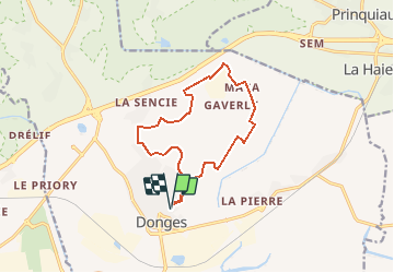
Tour Wandern von 12,4 km verfügbar auf Pays de la Loire, Loire-Atlantique, Donges. Diese Tour wird von gegele44 vorgeschlagen.
Beschreibung
Parking à la salle de sports. Depuis les jardins familiaux, longez le marais et grimpez sur la butte de la Grée pour apercevoir la vallée de la Loire. Revenez par les marais d'Errun.
Ort
Land:
France
Region :
Pays de la Loire
Abteilung/Provinz :
Loire-Atlantique
Kommune :
Donges
Standort:
Unknown
Gehen Sie:(Dec)
Gehen Sie:(UTM)
570176 ; 5241299 (30T) N.
Kommentare
Touren in der Umgebung
![Tour Wandern Corsept - Corsept_Digue de l'Estuaire - Photo](https://media.geolcdn.com/t/375/260/ext.jpg?maxdim=2&url=https%3A%2F%2Fservices.sitytrail.com%2FGeolivesWS%2FDownloadMedia.ashx%3FTrailID%3D477283%26Media%3Db7ba6cd1-1cc2-4ac5-a1ab-681dd095b16c.JPG)
![Wandern Wandern](https://static1.geolcdn.com/sitytour/trail-icons/101.png)
Corsept_Digue de l'Estuaire
Wandern
Medium
Corsept,
Pays de la Loire,
Loire-Atlantique,
France
![](/images/other/stat-length.png)
17,5 km | 18,6 km-effort
4h 10min
![](https://static1.geolcdn.com/siteimages/upload/files/16400158638029165_repeat_loop_refresh_sync_direction_icon.png)
Ja
![Tour Mountainbike Paimbœuf - Paimboeuf juin 23 - Photo](https://media.geolcdn.com/t/375/260/ext.jpg?maxdim=2&url=https%3A%2F%2Fstatic1.geolcdn.com%2Fsiteimages%2Fupload%2Ffiles%2F1524743154velo.jpg)
![Mountainbike Mountainbike](https://static1.geolcdn.com/sitytour/trail-icons/202.png)
Paimboeuf juin 23
Mountainbike
Medium
Paimbœuf,
Pays de la Loire,
Loire-Atlantique,
France
![](/images/other/stat-length.png)
26 km | 29 km-effort
2h 0min
![](https://static1.geolcdn.com/siteimages/upload/files/16400158638029165_repeat_loop_refresh_sync_direction_icon.png)
Ja
![Tour Wandern Corsept - CORSEPT - 2014-10-26 12km - Photo](https://media.geolcdn.com/t/375/260/ext.jpg?maxdim=2&url=https%3A%2F%2Fstatic1.geolcdn.com%2Fsiteimages%2Fupload%2Ffiles%2F1553511878bg_sport_marche.png)
![Wandern Wandern](https://static1.geolcdn.com/sitytour/trail-icons/101.png)
CORSEPT - 2014-10-26 12km
Wandern
Schwierig
Corsept,
Pays de la Loire,
Loire-Atlantique,
France
![](/images/other/stat-length.png)
12,5 km | 13,3 km-effort
3h 1min
![](https://static1.geolcdn.com/siteimages/upload/files/16400158638029165_repeat_loop_refresh_sync_direction_icon.png)
Ja
![Tour Mountainbike Paimbœuf - sôrtie vtt 20 janv 22 - Photo](https://media.geolcdn.com/t/375/260/ext.jpg?maxdim=2&url=https%3A%2F%2Fstatic1.geolcdn.com%2Fsiteimages%2Fupload%2Ffiles%2F1524743154velo.jpg)
![Mountainbike Mountainbike](https://static1.geolcdn.com/sitytour/trail-icons/202.png)
sôrtie vtt 20 janv 22
Mountainbike
Einfach
Paimbœuf,
Pays de la Loire,
Loire-Atlantique,
France
![](/images/other/stat-length.png)
47 km | 51 km-effort
3h 53min
![](https://static1.geolcdn.com/siteimages/upload/files/16400158638029165_repeat_loop_refresh_sync_direction_icon.png)
Ja
![Tour Wandern Corsept - Circuit de la digue à corset - Photo](https://media.geolcdn.com/t/375/260/ext.jpg?maxdim=2&url=https%3A%2F%2Fstatic1.geolcdn.com%2Fsiteimages%2Fupload%2Ffiles%2F1553511878bg_sport_marche.png)
![Wandern Wandern](https://static1.geolcdn.com/sitytour/trail-icons/101.png)
Circuit de la digue à corset
Wandern
Einfach
Corsept,
Pays de la Loire,
Loire-Atlantique,
France
![](/images/other/stat-length.png)
16,7 km | 17,7 km-effort
4h 50min
![](https://static1.geolcdn.com/siteimages/upload/files/16400158638029165_repeat_loop_refresh_sync_direction_icon.png)
Nein
![Tour Wandern Paimbœuf - Paimboeuf - Photo](https://media.geolcdn.com/t/375/260/ext.jpg?maxdim=2&url=https%3A%2F%2Fstatic1.geolcdn.com%2Fsiteimages%2Fupload%2Ffiles%2F1553511878bg_sport_marche.png)
![Wandern Wandern](https://static1.geolcdn.com/sitytour/trail-icons/101.png)
Paimboeuf
Wandern
Einfach
Paimbœuf,
Pays de la Loire,
Loire-Atlantique,
France
![](/images/other/stat-length.png)
12,4 km | 13,4 km-effort
3h 1min
![](https://static1.geolcdn.com/siteimages/upload/files/16400158638029165_repeat_loop_refresh_sync_direction_icon.png)
Ja
![Tour Wandern Corsept - Circuit des Menhirs - CORSEPT - Photo](https://media.geolcdn.com/t/375/260/ext.jpg?maxdim=2&url=https%3A%2F%2Fstatic1.geolcdn.com%2Fsiteimages%2Fupload%2Ffiles%2F1553511878bg_sport_marche.png)
![Wandern Wandern](https://static1.geolcdn.com/sitytour/trail-icons/101.png)
Circuit des Menhirs - CORSEPT
Wandern
Einfach
Corsept,
Pays de la Loire,
Loire-Atlantique,
France
![](/images/other/stat-length.png)
12,7 km | 13,6 km-effort
3h 1min
![](https://static1.geolcdn.com/siteimages/upload/files/16400158638029165_repeat_loop_refresh_sync_direction_icon.png)
Ja
![Tour Wandern Corsept - Circuit des Marais - CORSEPT - Photo](https://media.geolcdn.com/t/375/260/ext.jpg?maxdim=2&url=https%3A%2F%2Fstatic1.geolcdn.com%2Fsiteimages%2Fupload%2Ffiles%2F1553511878bg_sport_marche.png)
![Wandern Wandern](https://static1.geolcdn.com/sitytour/trail-icons/101.png)
Circuit des Marais - CORSEPT
Wandern
Einfach
Corsept,
Pays de la Loire,
Loire-Atlantique,
France
![](/images/other/stat-length.png)
10,8 km | 11,6 km-effort
2h 35min
![](https://static1.geolcdn.com/siteimages/upload/files/16400158638029165_repeat_loop_refresh_sync_direction_icon.png)
Ja
![Tour Wandern Donges - Chemin de la Butte - Photo](https://media.geolcdn.com/t/375/260/ext.jpg?maxdim=2&url=https%3A%2F%2Fstatic1.geolcdn.com%2Fsiteimages%2Fupload%2Ffiles%2F1553511878bg_sport_marche.png)
![Wandern Wandern](https://static1.geolcdn.com/sitytour/trail-icons/101.png)
Chemin de la Butte
Wandern
Einfach
(1)
Donges,
Pays de la Loire,
Loire-Atlantique,
France
![](/images/other/stat-length.png)
12,4 km | 13,5 km-effort
3h 0min
![](https://static1.geolcdn.com/siteimages/upload/files/16400158638029165_repeat_loop_refresh_sync_direction_icon.png)
Ja