![](/images/other/stat-length.png)
![Tour Wandern Cizay-la-Madeleine - Autour de l’Abbaye d’Asnières - Photo](https://media.geolcdn.com/t/1900/400/ext.pjpeg?maxdim=2&url=https%3A%2F%2Fstatic1.geolcdn.com%2Fsiteimages%2Fupload%2Ffiles%2F1553511878bg_sport_marche.png)
Autour de l’Abbaye d’Asnières
neoroll44
Benutzer
![Länge](/images/other/stat-length.png)
![Maximale Höhe](https://static1.geolcdn.com/siteimages/upload/files/1508320355ic_sort_altitude_max_24dp.png)
![Positive Höhendifferenz](https://static1.geolcdn.com/siteimages/upload/files/1508320355ic_sort_den_pos_24dp.png)
![Km-Effort](/images/other/stat-length.png)
![Min. Höhe](https://static1.geolcdn.com/siteimages/upload/files/1508320355ic_sort_altitude_min_24dp.png)
![Negative Höhendifferenz](https://static1.geolcdn.com/siteimages/upload/files/1508320355ic_sort_den_neg_24dp.png)
![Boucle](https://static1.geolcdn.com/siteimages/upload/files/16400158638029165_repeat_loop_refresh_sync_direction_icon.png)
![Wandern](https://static1.geolcdn.com/sitytour/trail-icons/101.png)
2h50
Schwierigkeit : Medium
![Scannen Sie diesen QR-Code, um die Tour in der SityTrail-Anwendung zu öffnen](https://capi.geolives.com/qq0zvz2zws4bq2lad0pu/sitytour/trails/3071170/qr.png?size=200)
Kostenlosegpshiking-Anwendung
Über SityTrail
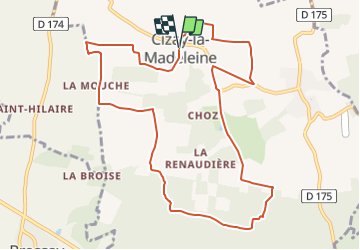
Tour Wandern von 11,1 km verfügbar auf Pays de la Loire, Maine-et-Loire, Cizay-la-Madeleine. Diese Tour wird von neoroll44 vorgeschlagen.
Beschreibung
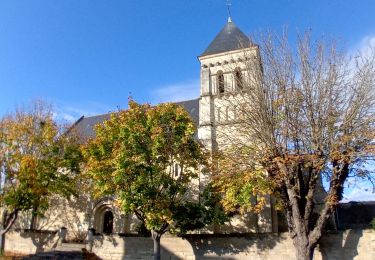
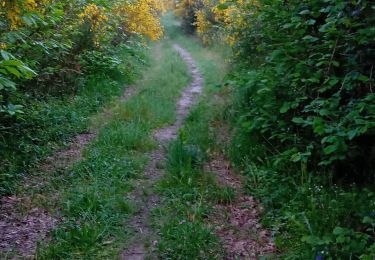
Départ : Place de l'église - Balisage : Jaune - Praticable en VTT/VTC
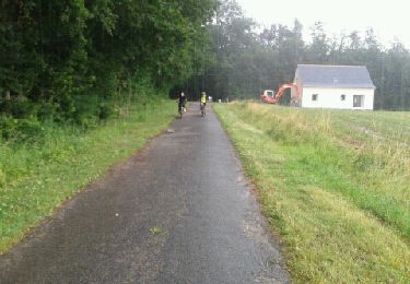
(D/A) De la place, prenez à gauche rue de l'Abbaye, puis prenez la deuxième à gauche sur le chemin. allez jusqu'au bout puis tournez à gauche. Au bout, tournez de nouveau à gauche. Continuez tout droit, puis prenez le chemin à votre gauche après La Mouche. Continuez tout droit, passez sous les fils électriques, et rejoignez la route.
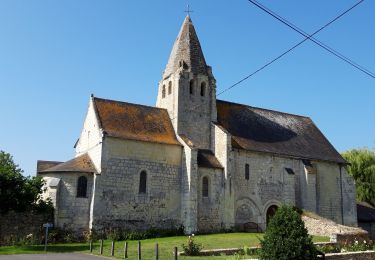
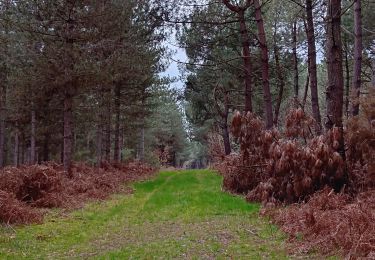
(1) Tournez à droite, continuez sur la route. Au carrefour allez tout droit, puis prenez le chemin jouxtant l'entrée de l'Abbaye d'Asnières. Pénétrez dans la forêt. Continuez tout droit jusqu'au carrefour de la Brèche aux Moines.
(2) Prenez le deuxième chemin à gauche. Continuez tout droit, en laissant deux fois les chemins à droite, et allez jusqu'à l'intersection.
(3) Tournez à gauche et au premier carrefour continuez tout droit jusqu'à la fourche.
(4) Bifurquez à gauche et continuez toujours tout droit. Passez devant le Château de Chozé et allez jusqu'au carrefour de la D163.
(5) Tournez à gauche puis prenez le premier chemin à droite. Retrouvez la route.
(6) Prenez à gauche puis à nouveau à gauche. Au bout, tournez à droite puis à gauche. Continuez jusqu'à l' intersection.
(7) Tournez à gauche puis rejoignez la route. Viré à gauche et au carrefour allez tout droit pour retrouvez votre point de départ. (D/A).
Ort
Kommentare
Touren in der Umgebung
![Tour Wandern Les Ulmes - Les Ulmes 24102024 - Photo](https://media.geolcdn.com/t/375/260/576f8cb1-c403-4cde-afde-d34f95501f4a.jpg&format=jpg&maxdim=2)
![Wandern Wandern](https://static1.geolcdn.com/sitytour/trail-icons/101.png)
Wandern
![](/images/other/stat-length.png)
![](https://static1.geolcdn.com/siteimages/upload/files/16400158638029165_repeat_loop_refresh_sync_direction_icon.png)
![Tour Wandern Les Ulmes - les ulmes 38 km - Photo](https://media.geolcdn.com/t/375/260/82c0202e-d02a-413c-ade0-e6b319c12be4.jpg&format=jpg&maxdim=2)
![Wandern Wandern](https://static1.geolcdn.com/sitytour/trail-icons/101.png)
Wandern
![](/images/other/stat-length.png)
![](https://static1.geolcdn.com/siteimages/upload/files/16400158638029165_repeat_loop_refresh_sync_direction_icon.png)
![Tour Mountainbike Montreuil-Bellay - 2012-07-14 13h35m46 - Photo](https://media.geolcdn.com/t/375/260/ext.jpg?maxdim=2&url=https%3A%2F%2Fservices.sitytrail.com%2FGeolivesWS%2FDownloadMedia.ashx%3FTrailID%3D139064%26Media%3D20120714103208.jpeg)
![Mountainbike Mountainbike](https://static1.geolcdn.com/sitytour/trail-icons/202.png)
Mountainbike
![](/images/other/stat-length.png)
![](https://static1.geolcdn.com/siteimages/upload/files/16400158638029165_repeat_loop_refresh_sync_direction_icon.png)
![Tour Wandern Cizay-la-Madeleine - cizay la madeleine - Photo](https://media.geolcdn.com/t/375/260/ext.jpg?maxdim=2&url=https%3A%2F%2Fstatic1.geolcdn.com%2Fsiteimages%2Fupload%2Ffiles%2F1553511878bg_sport_marche.png)
![Wandern Wandern](https://static1.geolcdn.com/sitytour/trail-icons/101.png)
Wandern
![](/images/other/stat-length.png)
![](https://static1.geolcdn.com/siteimages/upload/files/16400158638029165_repeat_loop_refresh_sync_direction_icon.png)
![Tour Wandern Les Ulmes - les ulmes 09052024 - Photo](https://media.geolcdn.com/t/375/260/0fd0f7a1-ce02-4759-a31d-266031cfdffd.jpg&format=jpg&maxdim=2)
![Wandern Wandern](https://static1.geolcdn.com/sitytour/trail-icons/101.png)
Wandern
![](/images/other/stat-length.png)
![](https://static1.geolcdn.com/siteimages/upload/files/16400158638029165_repeat_loop_refresh_sync_direction_icon.png)
![Tour Wandern Les Ulmes - les ulmes fh 22032024 - Photo](https://media.geolcdn.com/t/375/260/5bbb9f5a-b7a1-4431-a887-dd5bc8412579.jpg&format=jpg&maxdim=2)
![Wandern Wandern](https://static1.geolcdn.com/sitytour/trail-icons/101.png)
Wandern
![](/images/other/stat-length.png)
![](https://static1.geolcdn.com/siteimages/upload/files/16400158638029165_repeat_loop_refresh_sync_direction_icon.png)
![Tour Wandern Les Ulmes - les ulmes fh 24022024 - Photo](https://media.geolcdn.com/t/375/260/6f13b9d9-c377-48e6-8a3a-931a033dc0d7.jpg&format=jpg&maxdim=2)
![Wandern Wandern](https://static1.geolcdn.com/sitytour/trail-icons/101.png)
Wandern
![](/images/other/stat-length.png)
![](https://static1.geolcdn.com/siteimages/upload/files/16400158638029165_repeat_loop_refresh_sync_direction_icon.png)
![Tour Wandern Les Ulmes - les ulmes fast hiking 15022024 - Photo](https://media.geolcdn.com/t/375/260/10b64439-5696-4c85-b7c3-acd0209fa023.jpg&format=jpg&maxdim=2)
![Wandern Wandern](https://static1.geolcdn.com/sitytour/trail-icons/101.png)
Wandern
![](/images/other/stat-length.png)
![](https://static1.geolcdn.com/siteimages/upload/files/16400158638029165_repeat_loop_refresh_sync_direction_icon.png)
![Tour Wandern Les Ulmes - les ulmes 11022024 - Photo](https://media.geolcdn.com/t/375/260/95d7152d-7e1b-4f71-ae8c-a96f6c7ab3a8.jpg&format=jpg&maxdim=2)
![Wandern Wandern](https://static1.geolcdn.com/sitytour/trail-icons/101.png)
Wandern
![](/images/other/stat-length.png)
![](https://static1.geolcdn.com/siteimages/upload/files/16400158638029165_repeat_loop_refresh_sync_direction_icon.png)