![](/images/other/stat-length.png)
![Tour Schneeschuhwandern Susville - Pierre Plantée et Serre de l'Horizon en circuit - Photo](https://media.geolcdn.com/t/1900/400/1a4cc75c-12c8-4d11-bfe5-deaaacee3d47.jpg&format=pjpeg&maxdim=2)
Pierre Plantée et Serre de l'Horizon en circuit
Emelle
Benutzer
![Länge](/images/other/stat-length.png)
Länge
10,8 km
![Maximale Höhe](https://static1.geolcdn.com/siteimages/upload/files/1508320355ic_sort_altitude_max_24dp.png)
Maximale Höhe
1594 m
![Positive Höhendifferenz](https://static1.geolcdn.com/siteimages/upload/files/1508320355ic_sort_den_pos_24dp.png)
Positive Höhendifferenz
463 m
![Km-Effort](/images/other/stat-length.png)
Km-Effort
16,9 km
![Min. Höhe](https://static1.geolcdn.com/siteimages/upload/files/1508320355ic_sort_altitude_min_24dp.png)
Min. Höhe
1210 m
![Negative Höhendifferenz](https://static1.geolcdn.com/siteimages/upload/files/1508320355ic_sort_den_neg_24dp.png)
Negative Höhendifferenz
464 m
![Boucle](https://static1.geolcdn.com/siteimages/upload/files/16400158638029165_repeat_loop_refresh_sync_direction_icon.png)
Boucle
Ja
Erstellungsdatum :
2022-01-27 08:47:42.058
Letzte Änderung :
2022-01-29 16:56:44.724
![Schneeschuhwandern](https://static1.geolcdn.com/sitytour/trail-icons/504.png)
5h24
Schwierigkeit : Einfach
![Scannen Sie diesen QR-Code, um die Tour in der SityTrail-Anwendung zu öffnen](https://capi.geolives.com/qq0zvz2zws4bq2lad0pu/sitytour/trails/3066131/qr.png?size=200)
Kostenlosegpshiking-Anwendung
Über SityTrail
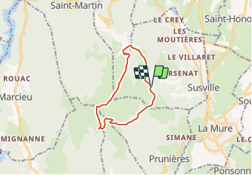
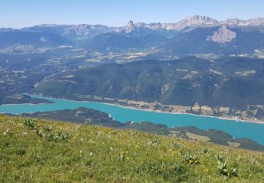
Tour Schneeschuhwandern von 10,8 km verfügbar auf Auvergne-Rhone-Alpen, Isère, Susville. Diese Tour wird von Emelle vorgeschlagen.
Beschreibung
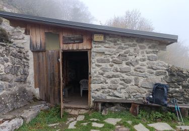
A u départ des Merlins.
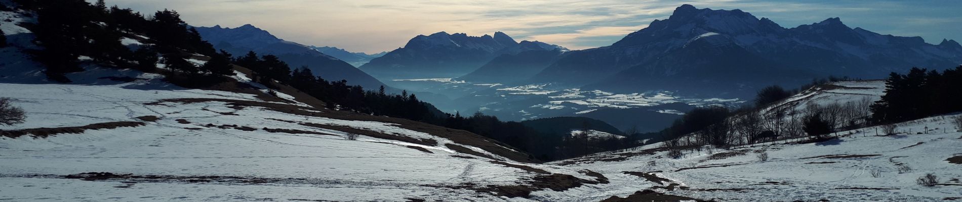
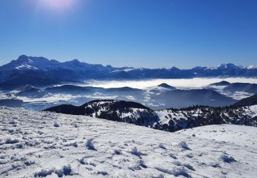
Utilisation uniquement des crampons et pas des raquettes, on s'enfonçait un peu sur le retour, mais cela était gérable.
Ort
Land:
France
Region :
Auvergne-Rhone-Alpen
Abteilung/Provinz :
Isère
Kommune :
Susville
Standort:
Unknown
Gehen Sie:(Dec)
Gehen Sie:(UTM)
717500 ; 4977513 (31T) N.
Kommentare
Touren in der Umgebung
![Tour Rennrad La Mure - La Mure les 4 lacs - Photo](https://media.geolcdn.com/t/375/260/ext.jpg?maxdim=2&url=https%3A%2F%2Fstatic1.geolcdn.com%2Fsiteimages%2Fupload%2Ffiles%2F1524743154velo.jpg)
![Rennrad Rennrad](https://static1.geolcdn.com/sitytour/trail-icons/201.png)
La Mure les 4 lacs
Rennrad
Medium
(1)
La Mure,
Auvergne-Rhone-Alpen,
Isère,
France
![](/images/other/stat-length.png)
58 km | 72 km-effort
4h 22min
![](https://static1.geolcdn.com/siteimages/upload/files/16400158638029165_repeat_loop_refresh_sync_direction_icon.png)
Ja
![Wandern Wandern](https://static1.geolcdn.com/sitytour/trail-icons/101.png)
PF-Pierre-Châtel - La Pierre Percée
Wandern
Schwierig
Pierre-Châtel,
Auvergne-Rhone-Alpen,
Isère,
France
![](/images/other/stat-length.png)
8,4 km | 12,9 km-effort
3h 46min
![](https://static1.geolcdn.com/siteimages/upload/files/16400158638029165_repeat_loop_refresh_sync_direction_icon.png)
Ja
![Tour Wandern La Motte-d'Aveillans - petite balade - Photo](https://media.geolcdn.com/t/375/260/c8ab192f-feb7-4747-af86-e7381ac953ed.jpg&format=jpg&maxdim=2)
![Wandern Wandern](https://static1.geolcdn.com/sitytour/trail-icons/101.png)
petite balade
Wandern
Medium
La Motte-d'Aveillans,
Auvergne-Rhone-Alpen,
Isère,
France
![](/images/other/stat-length.png)
5,1 km | 9,3 km-effort
3h 38min
![](https://static1.geolcdn.com/siteimages/upload/files/16400158638029165_repeat_loop_refresh_sync_direction_icon.png)
Ja
![Tour Wandern Mayres-Savel - Passerelles Hymalayene Mayres + 250 - Photo](https://media.geolcdn.com/t/375/260/e79ec6b2-c62a-43e0-95ca-91baa034bf5d.jpg&format=jpg&maxdim=2)
![Wandern Wandern](https://static1.geolcdn.com/sitytour/trail-icons/101.png)
Passerelles Hymalayene Mayres + 250
Wandern
Medium
Mayres-Savel,
Auvergne-Rhone-Alpen,
Isère,
France
![](/images/other/stat-length.png)
4,9 km | 8,2 km-effort
1h 59min
![](https://static1.geolcdn.com/siteimages/upload/files/16400158638029165_repeat_loop_refresh_sync_direction_icon.png)
Ja
![Tour Wandern Susville - Susville les Merlins boucle par le col du Sénépiy - Photo](https://media.geolcdn.com/t/375/260/e34bcbf0-51cf-49b5-a532-234a88d268fc.jpg&format=jpg&maxdim=2)
![Wandern Wandern](https://static1.geolcdn.com/sitytour/trail-icons/101.png)
Susville les Merlins boucle par le col du Sénépiy
Wandern
Medium
Susville,
Auvergne-Rhone-Alpen,
Isère,
France
![](/images/other/stat-length.png)
10,1 km | 16,3 km-effort
3h 30min
![](https://static1.geolcdn.com/siteimages/upload/files/16400158638029165_repeat_loop_refresh_sync_direction_icon.png)
Ja
![Tour Wandern Mayres-Savel - Randonnée des passerelles - Photo](https://media.geolcdn.com/t/375/260/f81885ad-9d99-466e-990d-175fbd3a925e.jpg&format=jpg&maxdim=2)
![Wandern Wandern](https://static1.geolcdn.com/sitytour/trail-icons/101.png)
Randonnée des passerelles
Wandern
Einfach
Mayres-Savel,
Auvergne-Rhone-Alpen,
Isère,
France
![](/images/other/stat-length.png)
11,9 km | 17,9 km-effort
4h 51min
![](https://static1.geolcdn.com/siteimages/upload/files/16400158638029165_repeat_loop_refresh_sync_direction_icon.png)
Nein
![Tour Wandern La Motte-Saint-Martin - Sinepi - Photo](https://media.geolcdn.com/t/375/260/ext.jpg?maxdim=2&url=https%3A%2F%2Fstatic1.geolcdn.com%2Fsiteimages%2Fupload%2Ffiles%2F1553511878bg_sport_marche.png)
![Wandern Wandern](https://static1.geolcdn.com/sitytour/trail-icons/101.png)
Sinepi
Wandern
(1)
La Motte-Saint-Martin,
Auvergne-Rhone-Alpen,
Isère,
France
![](/images/other/stat-length.png)
24 km | 40 km-effort
6h 0min
![](https://static1.geolcdn.com/siteimages/upload/files/16400158638029165_repeat_loop_refresh_sync_direction_icon.png)
Nein
![Tour Mountainbike La Motte-d'Aveillans - Le Sénépy depuis Les Signaraux - Photo](https://media.geolcdn.com/t/375/260/48b7fa7e-1a2a-4b01-b381-61d2b963f1f0.jpg&format=jpg&maxdim=2)
![Mountainbike Mountainbike](https://static1.geolcdn.com/sitytour/trail-icons/202.png)
Le Sénépy depuis Les Signaraux
Mountainbike
Medium
La Motte-d'Aveillans,
Auvergne-Rhone-Alpen,
Isère,
France
![](/images/other/stat-length.png)
20 km | 32 km-effort
3h 39min
![](https://static1.geolcdn.com/siteimages/upload/files/16400158638029165_repeat_loop_refresh_sync_direction_icon.png)
Ja
![Tour Wandern La Motte-d'Aveillans - Col du Sénépy et Pierre Plantée depuis les Signaraux - Photo](https://media.geolcdn.com/t/375/260/cfea585a-9c0d-41ae-ace9-cab390a4faa0.jpg&format=jpg&maxdim=2)
![Wandern Wandern](https://static1.geolcdn.com/sitytour/trail-icons/101.png)
Col du Sénépy et Pierre Plantée depuis les Signaraux
Wandern
Medium
La Motte-d'Aveillans,
Auvergne-Rhone-Alpen,
Isère,
France
![](/images/other/stat-length.png)
10,2 km | 15,8 km-effort
5h 39min
![](https://static1.geolcdn.com/siteimages/upload/files/16400158638029165_repeat_loop_refresh_sync_direction_icon.png)
Ja