![](/images/other/stat-length.png)
![Tour Schneeschuhwandern Avrieux - Maps3D 2022-01-26 15-43pm - Photo](https://media.geolcdn.com/t/1900/400/ext.pjpeg?maxdim=2&url=https%3A%2F%2Fstatic1.geolcdn.com%2Fsiteimages%2Fupload%2Ffiles%2F1524743153raquette.jpg)
Maps3D 2022-01-26 15-43pm
GGsavoie
Benutzer
![Länge](/images/other/stat-length.png)
Länge
9,6 km
![Maximale Höhe](https://static1.geolcdn.com/siteimages/upload/files/1508320355ic_sort_altitude_max_24dp.png)
Maximale Höhe
1810 m
![Positive Höhendifferenz](https://static1.geolcdn.com/siteimages/upload/files/1508320355ic_sort_den_pos_24dp.png)
Positive Höhendifferenz
607 m
![Km-Effort](/images/other/stat-length.png)
Km-Effort
17,3 km
![Min. Höhe](https://static1.geolcdn.com/siteimages/upload/files/1508320355ic_sort_altitude_min_24dp.png)
Min. Höhe
1259 m
![Negative Höhendifferenz](https://static1.geolcdn.com/siteimages/upload/files/1508320355ic_sort_den_neg_24dp.png)
Negative Höhendifferenz
482 m
![Boucle](https://static1.geolcdn.com/siteimages/upload/files/16400158638029165_repeat_loop_refresh_sync_direction_icon.png)
Boucle
Nein
Erstellungsdatum :
2022-01-26 17:38:44.0
Letzte Änderung :
2022-01-27 16:38:27.925
![Schneeschuhwandern](https://static1.geolcdn.com/sitytour/trail-icons/504.png)
5h00
Schwierigkeit : Schwierig
![Scannen Sie diesen QR-Code, um die Tour in der SityTrail-Anwendung zu öffnen](https://capi.geolives.com/qq0zvz2zws4bq2lad0pu/sitytour/trails/3065433/qr.png?size=200)
Kostenlosegpshiking-Anwendung
Über SityTrail
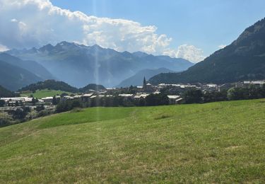
Tour Schneeschuhwandern von 9,6 km verfügbar auf Auvergne-Rhone-Alpen, Savoyen, Avrieux. Diese Tour wird von GGsavoie vorgeschlagen.
Beschreibung
Randonnée raquette en partant du pont du Nant (commune d'Avrieux) et pour aller sur le front de neige de La Repose (station de La Norma).
Ort
Land:
France
Region :
Auvergne-Rhone-Alpen
Abteilung/Provinz :
Savoyen
Kommune :
Avrieux
Standort:
Unknown
Gehen Sie:(Dec)
Gehen Sie:(UTM)
322161 ; 5008372 (32T) N.
Kommentare
Touren in der Umgebung
![Tour Laufen Aussois - Aussois Sardières par le Monolithe - Photo](https://media.geolcdn.com/t/375/260/ext.jpg?maxdim=2&url=https%3A%2F%2Fservices.sitytrail.com%2FGeolivesWS%2FDownloadMedia.ashx%3FTrailID%3D107068%26Media%3D11887_1.jpg)
![Laufen Laufen](https://static1.geolcdn.com/sitytour/trail-icons/103.png)
Aussois Sardières par le Monolithe
Laufen
Medium
(1)
Aussois,
Auvergne-Rhone-Alpen,
Savoyen,
France
![](/images/other/stat-length.png)
8,7 km | 12,4 km-effort
49min
![](https://static1.geolcdn.com/siteimages/upload/files/16400158638029165_repeat_loop_refresh_sync_direction_icon.png)
Ja
![Tour Wandern Avrieux - Lac de Pelouse - La Norma - Photo](https://media.geolcdn.com/t/375/260/ext.jpg?maxdim=2&url=https%3A%2F%2Fservices.sitytrail.com%2FGeolivesWS%2FDownloadMedia.ashx%3FTrailID%3D103703%26Media%3D6198_1.jpg)
![Wandern Wandern](https://static1.geolcdn.com/sitytour/trail-icons/101.png)
Lac de Pelouse - La Norma
Wandern
Medium
(1)
Avrieux,
Auvergne-Rhone-Alpen,
Savoyen,
France
![](/images/other/stat-length.png)
4,1 km | 11,1 km-effort
3h 0min
![](https://static1.geolcdn.com/siteimages/upload/files/16400158638029165_repeat_loop_refresh_sync_direction_icon.png)
Nein
![Tour Wandern Aussois - Aussois 250202 - Photo](https://media.geolcdn.com/t/375/260/d38662d9-9435-45eb-952c-43ded1766002.jpg&format=jpg&maxdim=2)
![Wandern Wandern](https://static1.geolcdn.com/sitytour/trail-icons/101.png)
Aussois 250202
Wandern
Sehr leicht
Aussois,
Auvergne-Rhone-Alpen,
Savoyen,
France
![](/images/other/stat-length.png)
5 km | 6,8 km-effort
1h 16min
![](https://static1.geolcdn.com/siteimages/upload/files/16400158638029165_repeat_loop_refresh_sync_direction_icon.png)
Nein
![Tour Wandern Avrieux - Col du Barbier et télégraphe - Photo](https://media.geolcdn.com/t/375/260/6ccb7b01-5841-4073-984c-e7b3df5e0f0f.jpg&format=jpg&maxdim=2)
![Wandern Wandern](https://static1.geolcdn.com/sitytour/trail-icons/101.png)
Col du Barbier et télégraphe
Wandern
Medium
Avrieux,
Auvergne-Rhone-Alpen,
Savoyen,
France
![](/images/other/stat-length.png)
13,4 km | 31 km-effort
4h 37min
![](https://static1.geolcdn.com/siteimages/upload/files/16400158638029165_repeat_loop_refresh_sync_direction_icon.png)
Ja
![Tour Skiwanderen Villarodin-Bourget - passage de la belle Plinier Nord - Photo](https://media.geolcdn.com/t/375/260/24fce6f9-d37e-4224-8f2c-4b95f0071df0.jpg&format=jpg&maxdim=2)
![Skiwanderen Skiwanderen](https://static1.geolcdn.com/sitytour/trail-icons/503.png)
passage de la belle Plinier Nord
Skiwanderen
Medium
Villarodin-Bourget,
Auvergne-Rhone-Alpen,
Savoyen,
France
![](/images/other/stat-length.png)
16 km | 37 km-effort
6h 1min
![](https://static1.geolcdn.com/siteimages/upload/files/16400158638029165_repeat_loop_refresh_sync_direction_icon.png)
Ja
![Tour Zu Fuß Aussois - Sentier Balcon de la Turra à la Loza - Photo](https://media.geolcdn.com/t/375/260/3e5c2531-30aa-4f0c-9b13-d787d4d53cef.jpeg&format=jpg&maxdim=2)
![Zu Fuß Zu Fuß](https://static1.geolcdn.com/sitytour/trail-icons/100.png)
Sentier Balcon de la Turra à la Loza
Zu Fuß
Medium
Aussois,
Auvergne-Rhone-Alpen,
Savoyen,
France
![](/images/other/stat-length.png)
13,2 km | 26 km-effort
5h 57min
![](https://static1.geolcdn.com/siteimages/upload/files/16400158638029165_repeat_loop_refresh_sync_direction_icon.png)
Ja
![Tour Zu Fuß Villarodin-Bourget - Vallon de l'Orgère - Photo](https://media.geolcdn.com/t/375/260/7808cf41-72f7-4322-acd1-b2150517cd1e.jpeg&format=jpg&maxdim=2)
![Zu Fuß Zu Fuß](https://static1.geolcdn.com/sitytour/trail-icons/100.png)
Vallon de l'Orgère
Zu Fuß
Einfach
Villarodin-Bourget,
Auvergne-Rhone-Alpen,
Savoyen,
France
![](/images/other/stat-length.png)
4 km | 5,9 km-effort
1h 19min
![](https://static1.geolcdn.com/siteimages/upload/files/16400158638029165_repeat_loop_refresh_sync_direction_icon.png)
Nein
![Tour Wandern Villarodin-Bourget - La Norma / Télécabine Melezet / Valfréjus - Photo](https://media.geolcdn.com/t/375/260/588a4be4-ac90-41f5-b3fb-9c859be949e5.jpg&format=jpg&maxdim=2)
![Wandern Wandern](https://static1.geolcdn.com/sitytour/trail-icons/101.png)
La Norma / Télécabine Melezet / Valfréjus
Wandern
Schwierig
Villarodin-Bourget,
Auvergne-Rhone-Alpen,
Savoyen,
France
![](/images/other/stat-length.png)
9,8 km | 22 km-effort
3h 56min
![](https://static1.geolcdn.com/siteimages/upload/files/16400158638029165_repeat_loop_refresh_sync_direction_icon.png)
Nein
![Tour Wandern Aussois - Parc archéologique d'Aussoi - Photo](https://media.geolcdn.com/t/375/260/959301aa-8f5a-40f2-ab23-d6e806eeb698.jpg&format=jpg&maxdim=2)
![Wandern Wandern](https://static1.geolcdn.com/sitytour/trail-icons/101.png)
Parc archéologique d'Aussoi
Wandern
Sehr leicht
Aussois,
Auvergne-Rhone-Alpen,
Savoyen,
France
![](/images/other/stat-length.png)
5 km | 7 km-effort
2h 9min
![](https://static1.geolcdn.com/siteimages/upload/files/16400158638029165_repeat_loop_refresh_sync_direction_icon.png)
Ja