![](/images/other/stat-length.png)
![Tour Mountainbike Soudeilles - Rando cool - Photo](https://media.geolcdn.com/t/1900/400/ext.pjpeg?maxdim=2&url=https%3A%2F%2Fstatic1.geolcdn.com%2Fsiteimages%2Fupload%2Ffiles%2F1524743154velo.jpg)
Rando cool
luclemoing
Benutzer
![Länge](/images/other/stat-length.png)
Länge
14,2 km
![Maximale Höhe](https://static1.geolcdn.com/siteimages/upload/files/1508320355ic_sort_altitude_max_24dp.png)
Maximale Höhe
630 m
![Positive Höhendifferenz](https://static1.geolcdn.com/siteimages/upload/files/1508320355ic_sort_den_pos_24dp.png)
Positive Höhendifferenz
269 m
![Km-Effort](/images/other/stat-length.png)
Km-Effort
17,7 km
![Min. Höhe](https://static1.geolcdn.com/siteimages/upload/files/1508320355ic_sort_altitude_min_24dp.png)
Min. Höhe
524 m
![Negative Höhendifferenz](https://static1.geolcdn.com/siteimages/upload/files/1508320355ic_sort_den_neg_24dp.png)
Negative Höhendifferenz
261 m
![Boucle](https://static1.geolcdn.com/siteimages/upload/files/16400158638029165_repeat_loop_refresh_sync_direction_icon.png)
Boucle
Ja
Erstellungsdatum :
2014-12-10 00:00:00.0
Letzte Änderung :
2014-12-10 00:00:00.0
![Mountainbike](https://static1.geolcdn.com/sitytour/trail-icons/202.png)
1h12
Schwierigkeit : Einfach
![Scannen Sie diesen QR-Code, um die Tour in der SityTrail-Anwendung zu öffnen](https://capi.geolives.com/qq0zvz2zws4bq2lad0pu/sitytour/trails/304955/qr.png?size=200)
Kostenlosegpshiking-Anwendung
Über SityTrail
Tour Mountainbike von 14,2 km verfügbar auf Neu-Aquitanien, Corrèze, Soudeilles. Diese Tour wird von luclemoing vorgeschlagen.
Beschreibung
Au départ du Vv le lac,cet itinéraire de 14kms vous fera traverser quelques chemins sympathique,notamment l'arrivée sur le Vv Cap France et le lac.
Ort
Land:
France
Region :
Neu-Aquitanien
Abteilung/Provinz :
Corrèze
Kommune :
Soudeilles
Standort:
Unknown
Gehen Sie:(Dec)
Gehen Sie:(UTM)
426488 ; 5030248 (31T) N.
Kommentare
Touren in der Umgebung
![Tour Wandern Darnets - boucle des Troubadours - Photo](https://media.geolcdn.com/t/375/260/ext.jpg?maxdim=2&url=https%3A%2F%2Fmedia.geolcdn.com%2Ff%2F1a6934bf-a452-46e4-b656-94f59b0625b4.jpg)
![Wandern Wandern](https://static1.geolcdn.com/sitytour/trail-icons/101.png)
boucle des Troubadours
Wandern
Medium
(2)
Darnets,
Neu-Aquitanien,
Corrèze,
France
![](/images/other/stat-length.png)
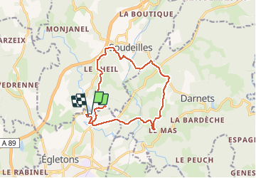
16 km | 21 km-effort
5h 26min
![](https://static1.geolcdn.com/siteimages/upload/files/16400158638029165_repeat_loop_refresh_sync_direction_icon.png)
Ja
![Tour Mountainbike Égletons - le tour d'egletons - Photo](https://media.geolcdn.com/t/375/260/ext.jpg?maxdim=2&url=https%3A%2F%2Fservices.sitytrail.com%2FGeolivesWS%2FDownloadMedia.ashx%3FTrailID%3D302065%26Media%3D20140504184613.jpg)
![Mountainbike Mountainbike](https://static1.geolcdn.com/sitytour/trail-icons/202.png)
le tour d'egletons
Mountainbike
Einfach
(1)
Égletons,
Neu-Aquitanien,
Corrèze,
France
![](/images/other/stat-length.png)
27 km | 34 km-effort
1h 16min
![](https://static1.geolcdn.com/siteimages/upload/files/16400158638029165_repeat_loop_refresh_sync_direction_icon.png)
Ja
![Tour Wandern Moustier-Ventadour - Découverte de Moustier Ventadour - Pays d'Egletons - Photo](https://media.geolcdn.com/t/375/260/ext.jpg?maxdim=2&url=https%3A%2F%2Fservices.sitytrail.com%2FGeolivesWS%2FDownloadMedia.ashx%3FTrailID%3D112285%26Media%3D10293_1.jpg)
![Wandern Wandern](https://static1.geolcdn.com/sitytour/trail-icons/101.png)
Découverte de Moustier Ventadour - Pays d'Egletons
Wandern
Medium
(1)
Moustier-Ventadour,
Neu-Aquitanien,
Corrèze,
France
![](/images/other/stat-length.png)
8,3 km | 12,2 km-effort
3h 0min
![](https://static1.geolcdn.com/siteimages/upload/files/16400158638029165_repeat_loop_refresh_sync_direction_icon.png)
Ja
![Tour Wandern Soudeilles - Soudeillette - Photo](https://media.geolcdn.com/t/375/260/ext.jpg?maxdim=2&url=https%3A%2F%2Fmedia.geolcdn.com%2Ff%2Fb08bb52f-45ad-4232-897a-87776904af4d.jpg)
![Wandern Wandern](https://static1.geolcdn.com/sitytour/trail-icons/101.png)
Soudeillette
Wandern
Schwierig
Soudeilles,
Neu-Aquitanien,
Corrèze,
France
![](/images/other/stat-length.png)
13,6 km | 17,3 km-effort
3h 40min
![](https://static1.geolcdn.com/siteimages/upload/files/16400158638029165_repeat_loop_refresh_sync_direction_icon.png)
Ja
![Tour Zu Fuß Rosiers-d'Égletons - Le Puy des Places - Photo](https://media.geolcdn.com/t/375/260/ext.jpg?maxdim=2&url=https%3A%2F%2Fmedia.geolcdn.com%2Ff%2F276f2976-67c7-4b61-81b4-6fa50409346e.jpg)
![Zu Fuß Zu Fuß](https://static1.geolcdn.com/sitytour/trail-icons/100.png)
Le Puy des Places
Zu Fuß
Einfach
Rosiers-d'Égletons,
Neu-Aquitanien,
Corrèze,
France
![](/images/other/stat-length.png)
13,2 km | 17,2 km-effort
3h 56min
![](https://static1.geolcdn.com/siteimages/upload/files/16400158638029165_repeat_loop_refresh_sync_direction_icon.png)
Ja
![Tour Wandern Moustier-Ventadour - Fred moutier ventadour - Photo](https://media.geolcdn.com/t/375/260/ext.jpg?maxdim=2&url=https%3A%2F%2Fmedia.geolcdn.com%2Ff%2F1e0a23f1-f7d2-422d-b518-af52e46c17f0.jpg)
![Wandern Wandern](https://static1.geolcdn.com/sitytour/trail-icons/101.png)
Fred moutier ventadour
Wandern
Sehr leicht
Moustier-Ventadour,
Neu-Aquitanien,
Corrèze,
France
![](/images/other/stat-length.png)
8,3 km | 12,3 km-effort
2h 53min
![](https://static1.geolcdn.com/siteimages/upload/files/16400158638029165_repeat_loop_refresh_sync_direction_icon.png)
Nein
![Tour Wandern Égletons - Entre Vedrenne et la Brette - variante courte - Égletons - Pays d'Égletons - Photo](https://media.geolcdn.com/t/375/260/ext.jpg?maxdim=2&url=https%3A%2F%2Fservices.sitytrail.com%2FGeolivesWS%2FDownloadMedia.ashx%3FTrailID%3D112292%26Media%3D10302_1.jpg)
![Wandern Wandern](https://static1.geolcdn.com/sitytour/trail-icons/101.png)
Entre Vedrenne et la Brette - variante courte - Égletons - Pays d'Égletons
Wandern
Medium
Égletons,
Neu-Aquitanien,
Corrèze,
France
![](/images/other/stat-length.png)
8,7 km | 11,5 km-effort
2h 0min
![](https://static1.geolcdn.com/siteimages/upload/files/16400158638029165_repeat_loop_refresh_sync_direction_icon.png)
Ja
![Tour Pferd Égletons - Entre Vedrenne et la Brette - Egletons - Pays d'Egletons - Photo](https://media.geolcdn.com/t/375/260/ext.jpg?maxdim=2&url=https%3A%2F%2Fservices.sitytrail.com%2FGeolivesWS%2FDownloadMedia.ashx%3FTrailID%3D112289%26Media%3D10299_1.jpg)
![Pferd Pferd](https://static1.geolcdn.com/sitytour/trail-icons/300.png)
Entre Vedrenne et la Brette - Egletons - Pays d'Egletons
Pferd
Medium
(1)
Égletons,
Neu-Aquitanien,
Corrèze,
France
![](/images/other/stat-length.png)
11,7 km | 15,6 km-effort
2h 0min
![](https://static1.geolcdn.com/siteimages/upload/files/16400158638029165_repeat_loop_refresh_sync_direction_icon.png)
Ja
![Tour Mountainbike Égletons - Entre Vedrenne et la Brette - Egletons - Pays d'Egletons - Photo](https://media.geolcdn.com/t/375/260/ext.jpg?maxdim=2&url=https%3A%2F%2Fservices.sitytrail.com%2FGeolivesWS%2FDownloadMedia.ashx%3FTrailID%3D112288%26Media%3D10299_1.jpg)
![Mountainbike Mountainbike](https://static1.geolcdn.com/sitytour/trail-icons/202.png)
Entre Vedrenne et la Brette - Egletons - Pays d'Egletons
Mountainbike
Medium
Égletons,
Neu-Aquitanien,
Corrèze,
France
![](/images/other/stat-length.png)
11,7 km | 15,6 km-effort
1h 0min
![](https://static1.geolcdn.com/siteimages/upload/files/16400158638029165_repeat_loop_refresh_sync_direction_icon.png)
Ja