![](/images/other/stat-length.png)
![Tour Wandern Saint-Donat - St_Donat_Bertinet - Photo](https://media.geolcdn.com/t/1900/400/dddf4646-242b-4b5a-a535-11869b301df6.jpg&format=pjpeg&maxdim=2)
St_Donat_Bertinet
jagarnier
Benutzer GUIDE
![Länge](/images/other/stat-length.png)
Länge
9,3 km
![Maximale Höhe](https://static1.geolcdn.com/siteimages/upload/files/1508320355ic_sort_altitude_max_24dp.png)
Maximale Höhe
1088 m
![Positive Höhendifferenz](https://static1.geolcdn.com/siteimages/upload/files/1508320355ic_sort_den_pos_24dp.png)
Positive Höhendifferenz
205 m
![Km-Effort](/images/other/stat-length.png)
Km-Effort
12,1 km
![Min. Höhe](https://static1.geolcdn.com/siteimages/upload/files/1508320355ic_sort_altitude_min_24dp.png)
Min. Höhe
992 m
![Negative Höhendifferenz](https://static1.geolcdn.com/siteimages/upload/files/1508320355ic_sort_den_neg_24dp.png)
Negative Höhendifferenz
205 m
![Boucle](https://static1.geolcdn.com/siteimages/upload/files/16400158638029165_repeat_loop_refresh_sync_direction_icon.png)
Boucle
Ja
Erstellungsdatum :
2022-01-12 13:58:36.904
Letzte Änderung :
2023-12-14 08:10:32.691
![Wandern](https://static1.geolcdn.com/sitytour/trail-icons/101.png)
2h45
Schwierigkeit : Einfach
![Scannen Sie diesen QR-Code, um die Tour in der SityTrail-Anwendung zu öffnen](https://capi.geolives.com/qq0zvz2zws4bq2lad0pu/sitytour/trails/3049094/qr.png?size=200)
Kostenlosegpshiking-Anwendung
Über SityTrail
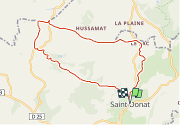
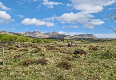
Tour Wandern von 9,3 km verfügbar auf Auvergne-Rhone-Alpen, Puy-de-Dôme, Saint-Donat. Diese Tour wird von jagarnier vorgeschlagen.
Beschreibung
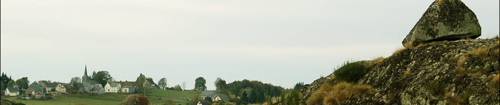
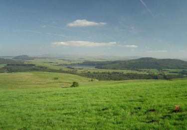
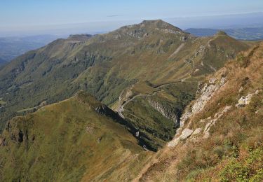
Le plateau de Saint-Donat offre des panoramas sur le Sancy et l’Artense parmi les plus beaux de la région. Les glaciers ont façonné des paysages de landes, fougères et de tourbières. Une curiosité à voir : le rocher en équilibre de «La Roche Juchée».
Ort
Land:
France
Region :
Auvergne-Rhone-Alpen
Abteilung/Provinz :
Puy-de-Dôme
Kommune :
Saint-Donat
Standort:
Unknown
Gehen Sie:(Dec)
Gehen Sie:(UTM)
477990 ; 5035111 (31T) N.
Kommentare
Touren in der Umgebung
![Tour Wandern Chastreix - Chastreix. cascades et tourbières - Photo](https://media.geolcdn.com/t/375/260/ext.jpg?maxdim=2&url=https%3A%2F%2Fservices.sitytrail.com%2FGeolivesWS%2FDownloadMedia.ashx%3FTrailID%3D449099%26Media%3Dfix__20150723174649.jpg)
![Wandern Wandern](https://static1.geolcdn.com/sitytour/trail-icons/101.png)
Chastreix. cascades et tourbières
Wandern
Einfach
(1)
Chastreix,
Auvergne-Rhone-Alpen,
Puy-de-Dôme,
France
![](/images/other/stat-length.png)
13,8 km | 18,3 km-effort
4h 5min
![](https://static1.geolcdn.com/siteimages/upload/files/16400158638029165_repeat_loop_refresh_sync_direction_icon.png)
Ja
![Tour Mountainbike Picherande - Espace VTT FFC du Sancy - Circuit n°10 - L'Escudor - Secteur Picherande - Photo](https://media.geolcdn.com/t/375/260/ext.jpg?maxdim=2&url=https%3A%2F%2Fservices.sitytrail.com%2FGeolivesWS%2FDownloadMedia.ashx%3FTrailID%3D106754%26Media%3D11421_2.jpg)
![Mountainbike Mountainbike](https://static1.geolcdn.com/sitytour/trail-icons/202.png)
Espace VTT FFC du Sancy - Circuit n°10 - L'Escudor - Secteur Picherande
Mountainbike
Schwierig
(1)
Picherande,
Auvergne-Rhone-Alpen,
Puy-de-Dôme,
France
![](/images/other/stat-length.png)
14,9 km | 19,8 km-effort
1h 10min
![](https://static1.geolcdn.com/siteimages/upload/files/16400158638029165_repeat_loop_refresh_sync_direction_icon.png)
Ja
![Tour Zu Fuß Saint-Genès-Champespe - Le Lac de la Crégut - Photo](https://media.geolcdn.com/t/375/260/cdd8ac38-82d5-454a-9f9d-2766fd79d9d7.jpeg&format=jpg&maxdim=2)
![Zu Fuß Zu Fuß](https://static1.geolcdn.com/sitytour/trail-icons/100.png)
Le Lac de la Crégut
Zu Fuß
Einfach
Saint-Genès-Champespe,
Auvergne-Rhone-Alpen,
Puy-de-Dôme,
France
![](/images/other/stat-length.png)
14 km | 17,7 km-effort
4h 1min
![](https://static1.geolcdn.com/siteimages/upload/files/16400158638029165_repeat_loop_refresh_sync_direction_icon.png)
Ja
![Tour Zu Fuß Saint-Donat - Bertinet - Photo](https://media.geolcdn.com/t/375/260/e84670f2-609d-4896-af9a-491ca9beaa74.jpeg&format=jpg&maxdim=2)
![Zu Fuß Zu Fuß](https://static1.geolcdn.com/sitytour/trail-icons/100.png)
Bertinet
Zu Fuß
Einfach
Saint-Donat,
Auvergne-Rhone-Alpen,
Puy-de-Dôme,
France
![](/images/other/stat-length.png)
7,9 km | 10 km-effort
2h 15min
![](https://static1.geolcdn.com/siteimages/upload/files/16400158638029165_repeat_loop_refresh_sync_direction_icon.png)
Ja
![Tour Zu Fuß Chastreix - Bois de la Masse - Photo](https://media.geolcdn.com/t/375/260/e7e44e0f-5c3a-45fa-ad81-e2da1af49124.jpeg&format=jpg&maxdim=2)
![Zu Fuß Zu Fuß](https://static1.geolcdn.com/sitytour/trail-icons/100.png)
Bois de la Masse
Zu Fuß
Einfach
Chastreix,
Auvergne-Rhone-Alpen,
Puy-de-Dôme,
France
![](/images/other/stat-length.png)
12,2 km | 16,2 km-effort
3h 40min
![](https://static1.geolcdn.com/siteimages/upload/files/16400158638029165_repeat_loop_refresh_sync_direction_icon.png)
Ja
![Tour Zu Fuß Picherande - La Fontaine Salée - Photo](https://media.geolcdn.com/t/375/260/6bb9750a-cfda-4ba6-aad3-02a83bb6e73a.jpeg&format=jpg&maxdim=2)
![Zu Fuß Zu Fuß](https://static1.geolcdn.com/sitytour/trail-icons/100.png)
La Fontaine Salée
Zu Fuß
Medium
Picherande,
Auvergne-Rhone-Alpen,
Puy-de-Dôme,
France
![](/images/other/stat-length.png)
20 km | 29 km-effort
6h 41min
![](https://static1.geolcdn.com/siteimages/upload/files/16400158638029165_repeat_loop_refresh_sync_direction_icon.png)
Ja
![Tour Zu Fuß Chastreix - Chastreix+la réserve_Bois_dela_Masse - Photo](https://media.geolcdn.com/t/375/260/ext.jpg?maxdim=2&url=https%3A%2F%2Fstatic1.geolcdn.com%2Fsiteimages%2Fupload%2Ffiles%2F1545311037marcheuse_200dpi.jpg)
![Zu Fuß Zu Fuß](https://static1.geolcdn.com/sitytour/trail-icons/100.png)
Chastreix+la réserve_Bois_dela_Masse
Zu Fuß
Einfach
(1)
Chastreix,
Auvergne-Rhone-Alpen,
Puy-de-Dôme,
France
![](/images/other/stat-length.png)
9 km | 12,4 km-effort
2h 48min
![](https://static1.geolcdn.com/siteimages/upload/files/16400158638029165_repeat_loop_refresh_sync_direction_icon.png)
Ja
![Tour Wandern Picherande - Picherande - Photo](https://media.geolcdn.com/t/375/260/3cb6325e-0604-4dca-8d4c-904f68d7fe48.jpg&format=jpg&maxdim=2)
![Wandern Wandern](https://static1.geolcdn.com/sitytour/trail-icons/101.png)
Picherande
Wandern
Sehr leicht
Picherande,
Auvergne-Rhone-Alpen,
Puy-de-Dôme,
France
![](/images/other/stat-length.png)
9,4 km | 12,3 km-effort
2h 19min
![](https://static1.geolcdn.com/siteimages/upload/files/16400158638029165_repeat_loop_refresh_sync_direction_icon.png)
Ja
![Tour Wandern Chastreix - Chastreix - Photo](https://media.geolcdn.com/t/375/260/5c9fdc40-e2cf-4745-88c9-c82962365e2d.jpg&format=jpg&maxdim=2)
![Wandern Wandern](https://static1.geolcdn.com/sitytour/trail-icons/101.png)
Chastreix
Wandern
Schwierig
Chastreix,
Auvergne-Rhone-Alpen,
Puy-de-Dôme,
France
![](/images/other/stat-length.png)
12,9 km | 16,8 km-effort
3h 49min
![](https://static1.geolcdn.com/siteimages/upload/files/16400158638029165_repeat_loop_refresh_sync_direction_icon.png)
Ja