![](/images/other/stat-length.png)
![Tour Fahrrad Grimaud - sortie vélo route dans le var - Photo](https://media.geolcdn.com/t/1900/400/ext.pjpeg?maxdim=2&url=https%3A%2F%2Fstatic1.geolcdn.com%2Fsiteimages%2Fupload%2Ffiles%2F1524743154velo.jpg)
sortie vélo route dans le var
olivier26
Benutzer
![Länge](/images/other/stat-length.png)
Länge
68 km
![Maximale Höhe](https://static1.geolcdn.com/siteimages/upload/files/1508320355ic_sort_altitude_max_24dp.png)
Maximale Höhe
354 m
![Positive Höhendifferenz](https://static1.geolcdn.com/siteimages/upload/files/1508320355ic_sort_den_pos_24dp.png)
Positive Höhendifferenz
898 m
![Km-Effort](/images/other/stat-length.png)
Km-Effort
80 km
![Min. Höhe](https://static1.geolcdn.com/siteimages/upload/files/1508320355ic_sort_altitude_min_24dp.png)
Min. Höhe
0 m
![Negative Höhendifferenz](https://static1.geolcdn.com/siteimages/upload/files/1508320355ic_sort_den_neg_24dp.png)
Negative Höhendifferenz
898 m
![Boucle](https://static1.geolcdn.com/siteimages/upload/files/16400158638029165_repeat_loop_refresh_sync_direction_icon.png)
Boucle
Ja
Erstellungsdatum :
2014-12-10 00:00:00.0
Letzte Änderung :
2014-12-10 00:00:00.0
![Fahrrad](https://static1.geolcdn.com/sitytour/trail-icons/200.png)
3h17
Schwierigkeit : Medium
![Scannen Sie diesen QR-Code, um die Tour in der SityTrail-Anwendung zu öffnen](https://capi.geolives.com/qq0zvz2zws4bq2lad0pu/sitytour/trails/304550/qr.png?size=200)
Kostenlosegpshiking-Anwendung
Über SityTrail
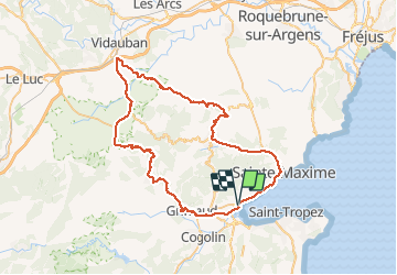
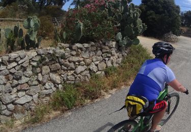
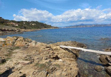
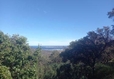
Tour Fahrrad von 68 km verfügbar auf Provence-Alpes-Côte d'Azur, Var, Grimaud. Diese Tour wird von olivier26 vorgeschlagen.
Beschreibung
boucle dans le massif des maures, par grimaud, garde frenet, vidauban, plan de la tour, st maxime, port grimaud
Ort
Land:
France
Region :
Provence-Alpes-Côte d'Azur
Abteilung/Provinz :
Var
Kommune :
Grimaud
Standort:
Unknown
Gehen Sie:(Dec)
Gehen Sie:(UTM)
303664 ; 4794607 (32T) N.
Kommentare
Touren in der Umgebung
![Tour Mountainbike Cogolin - peinier - Photo](https://media.geolcdn.com/t/375/260/ext.jpg?maxdim=2&url=https%3A%2F%2Fservices.sitytrail.com%2FGeolivesWS%2FDownloadMedia.ashx%3FTrailID%3D137318%26Media%3D20120704191905.jpeg)
![Mountainbike Mountainbike](https://static1.geolcdn.com/sitytour/trail-icons/202.png)
peinier
Mountainbike
Medium
(1)
Cogolin,
Provence-Alpes-Côte d'Azur,
Var,
France
![](/images/other/stat-length.png)
30 km | 40 km-effort
1h 57min
![](https://static1.geolcdn.com/siteimages/upload/files/16400158638029165_repeat_loop_refresh_sync_direction_icon.png)
Ja
![Tour Wandern Saint-Tropez - Golfe de St Tropez - Photo](https://media.geolcdn.com/t/375/260/ext.jpg?maxdim=2&url=https%3A%2F%2Fservices.sitytrail.com%2FGeolivesWS%2FDownloadMedia.ashx%3FTrailID%3D107154%26Media%3D11997_5.jpg)
![Wandern Wandern](https://static1.geolcdn.com/sitytour/trail-icons/101.png)
Golfe de St Tropez
Wandern
Schwierig
(2)
Saint-Tropez,
Provence-Alpes-Côte d'Azur,
Var,
France
![](/images/other/stat-length.png)
15,1 km | 17,6 km-effort
4h 30min
![](https://static1.geolcdn.com/siteimages/upload/files/16400158638029165_repeat_loop_refresh_sync_direction_icon.png)
Ja
![Tour Wandern Cogolin - val d\'Astier,St Ferreol, Pradels,val d\'Astier - Photo](https://media.geolcdn.com/t/375/260/ext.jpg?maxdim=2&url=https%3A%2F%2Fstatic1.geolcdn.com%2Fsiteimages%2Fupload%2Ffiles%2F1553511878bg_sport_marche.png)
![Wandern Wandern](https://static1.geolcdn.com/sitytour/trail-icons/101.png)
val d\'Astier,St Ferreol, Pradels,val d\'Astier
Wandern
Schwierig
(1)
Cogolin,
Provence-Alpes-Côte d'Azur,
Var,
France
![](/images/other/stat-length.png)
12 km | 17,3 km-effort
5h 0min
![](https://static1.geolcdn.com/siteimages/upload/files/16400158638029165_repeat_loop_refresh_sync_direction_icon.png)
Ja
![Tour Mountainbike Grimaud - VTT de Port -Grimaud - Photo](https://media.geolcdn.com/t/375/260/ext.jpg?maxdim=2&url=https%3A%2F%2Fservices.sitytrail.com%2FGeolivesWS%2FDownloadMedia.ashx%3FTrailID%3D795928%26Media%3Dd1a4096c-7e26-4780-acbc-fe0cf30ee0df.JPG)
![Mountainbike Mountainbike](https://static1.geolcdn.com/sitytour/trail-icons/202.png)
VTT de Port -Grimaud
Mountainbike
Medium
Grimaud,
Provence-Alpes-Côte d'Azur,
Var,
France
![](/images/other/stat-length.png)
21 km | 26 km-effort
1h 45min
![](https://static1.geolcdn.com/siteimages/upload/files/16400158638029165_repeat_loop_refresh_sync_direction_icon.png)
Ja
![Tour Mountainbike Grimaud - VTT du Plan de la Tour - Photo](https://media.geolcdn.com/t/375/260/ext.jpg?maxdim=2&url=https%3A%2F%2Fservices.sitytrail.com%2FGeolivesWS%2FDownloadMedia.ashx%3FTrailID%3D787323%26Media%3D86ee6b79-1220-4d35-8e8c-b77bb4ae8c68.JPG)
![Mountainbike Mountainbike](https://static1.geolcdn.com/sitytour/trail-icons/202.png)
VTT du Plan de la Tour
Mountainbike
Schwierig
(1)
Grimaud,
Provence-Alpes-Côte d'Azur,
Var,
France
![](/images/other/stat-length.png)
35 km | 46 km-effort
2h 59min
![](https://static1.geolcdn.com/siteimages/upload/files/16400158638029165_repeat_loop_refresh_sync_direction_icon.png)
Ja
![Tour Mountainbike Gassin - La Nartelle- depart Bourrian - Photo](https://media.geolcdn.com/t/375/260/ext.jpg?maxdim=2&url=https%3A%2F%2Fstatic1.geolcdn.com%2Fsiteimages%2Fupload%2Ffiles%2F1524743154velo.jpg)
![Mountainbike Mountainbike](https://static1.geolcdn.com/sitytour/trail-icons/202.png)
La Nartelle- depart Bourrian
Mountainbike
Medium
(1)
Gassin,
Provence-Alpes-Côte d'Azur,
Var,
France
![](/images/other/stat-length.png)
24 km | 31 km-effort
3h 11min
![](https://static1.geolcdn.com/siteimages/upload/files/16400158638029165_repeat_loop_refresh_sync_direction_icon.png)
Ja
![Tour Mountainbike Gassin - Patapan - Photo](https://media.geolcdn.com/t/375/260/ext.jpg?maxdim=2&url=https%3A%2F%2Fstatic1.geolcdn.com%2Fsiteimages%2Fupload%2Ffiles%2F1524743154velo.jpg)
![Mountainbike Mountainbike](https://static1.geolcdn.com/sitytour/trail-icons/202.png)
Patapan
Mountainbike
Medium
(1)
Gassin,
Provence-Alpes-Côte d'Azur,
Var,
France
![](/images/other/stat-length.png)
37 km | 47 km-effort
2h 24min
![](https://static1.geolcdn.com/siteimages/upload/files/16400158638029165_repeat_loop_refresh_sync_direction_icon.png)
Nein
![Tour Wandern Saint-Tropez - St Tropez littoral - Photo](https://media.geolcdn.com/t/375/260/072b31b2-52f6-4dca-a49f-5baffe5c7dc9.jpg&format=jpg&maxdim=2)
![Wandern Wandern](https://static1.geolcdn.com/sitytour/trail-icons/101.png)
St Tropez littoral
Wandern
Medium
Saint-Tropez,
Provence-Alpes-Côte d'Azur,
Var,
France
![](/images/other/stat-length.png)
18,3 km | 22 km-effort
6h 3min
![](https://static1.geolcdn.com/siteimages/upload/files/16400158638029165_repeat_loop_refresh_sync_direction_icon.png)
Ja
![Tour Wandern Grimaud - Grimaud - le pont des fées - Mont Roux 11.3.23 - Photo](https://media.geolcdn.com/t/375/260/b931d4cf-3c48-45c3-9286-94f622997895.jpg&format=jpg&maxdim=2)
![Wandern Wandern](https://static1.geolcdn.com/sitytour/trail-icons/101.png)
Grimaud - le pont des fées - Mont Roux 11.3.23
Wandern
Medium
Grimaud,
Provence-Alpes-Côte d'Azur,
Var,
France
![](/images/other/stat-length.png)
8,6 km | 13,7 km-effort
3h 15min
![](https://static1.geolcdn.com/siteimages/upload/files/16400158638029165_repeat_loop_refresh_sync_direction_icon.png)
Ja