![](/images/other/stat-length.png)
Haut Chenois - Edouard - Mortehan - Cimetière classé
ed1769
Benutzer
![Länge](/images/other/stat-length.png)
Länge
3,5 km
![Maximale Höhe](https://static1.geolcdn.com/siteimages/upload/files/1508320355ic_sort_altitude_max_24dp.png)
Maximale Höhe
319 m
![Positive Höhendifferenz](https://static1.geolcdn.com/siteimages/upload/files/1508320355ic_sort_den_pos_24dp.png)
Positive Höhendifferenz
89 m
![Km-Effort](/images/other/stat-length.png)
Km-Effort
4,7 km
![Min. Höhe](https://static1.geolcdn.com/siteimages/upload/files/1508320355ic_sort_altitude_min_24dp.png)
Min. Höhe
240 m
![Negative Höhendifferenz](https://static1.geolcdn.com/siteimages/upload/files/1508320355ic_sort_den_neg_24dp.png)
Negative Höhendifferenz
86 m
![Boucle](https://static1.geolcdn.com/siteimages/upload/files/16400158638029165_repeat_loop_refresh_sync_direction_icon.png)
Boucle
Ja
Erstellungsdatum :
2022-01-03 14:23:55.092
Letzte Änderung :
2022-01-05 14:12:22.353
![Zu Fuß](https://static1.geolcdn.com/sitytour/trail-icons/100.png)
1h04
Schwierigkeit : Einfach
![Scannen Sie diesen QR-Code, um die Tour in der SityTrail-Anwendung zu öffnen](https://capi.geolives.com/qq0zvz2zws4bq2lad0pu/sitytour/trails/3040552/qr.png?size=200)
Kostenlosegpshiking-Anwendung
Über SityTrail
Tour Zu Fuß von 3,5 km verfügbar auf Wallonien, Luxemburg, Bertrix. Diese Tour wird von ed1769 vorgeschlagen.
Beschreibung
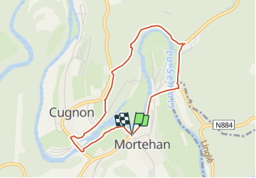
Parking at the church of Mortehan ( 4 km from Herbeumont )
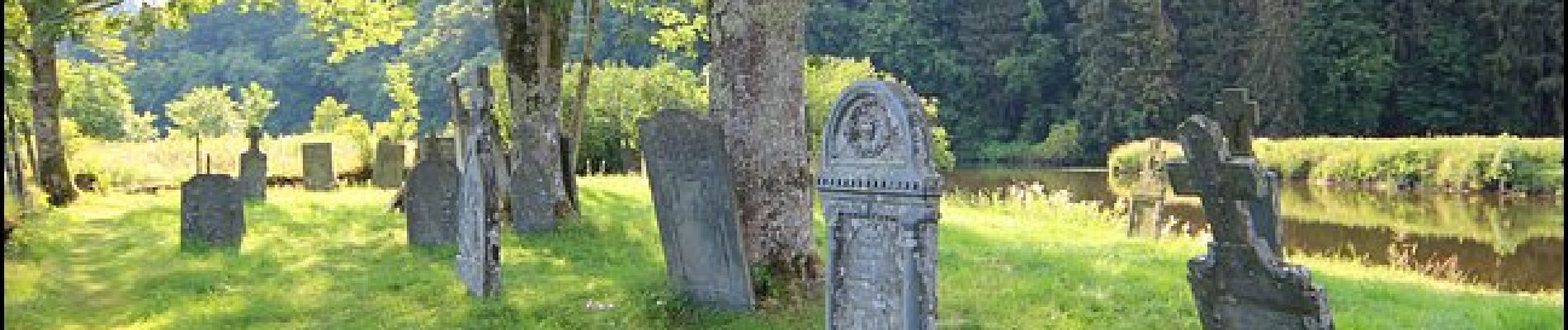
A visit to another world with its shale tombstones from the 16th and 17th centuries, then a fabulous steep path above the semois which is worth walking
Ort
Land:
Belgium
Region :
Wallonien
Abteilung/Provinz :
Luxemburg
Kommune :
Bertrix
Standort:
Unknown
Gehen Sie:(Dec)
Gehen Sie:(UTM)
659078 ; 5518767 (31U) N.
Kommentare
Touren in der Umgebung
![Tour Andere Aktivitäten Bertrix - BX08 - Photo](https://media.geolcdn.com/t/375/260/ext.jpg?maxdim=2&url=https%3A%2F%2Fstatic1.geolcdn.com%2Fsiteimages%2Fupload%2Ffiles%2F1545311037marcheuse_200dpi.jpg)
![Andere Aktivitäten Andere Aktivitäten](https://static1.geolcdn.com/sitytour/trail-icons/900.png)
BX08
Andere Aktivitäten
Sehr leicht
(9)
Bertrix,
Wallonien,
Luxemburg,
Belgium
![](/images/other/stat-length.png)
7,3 km | 10 km-effort
2h 30min
![](https://static1.geolcdn.com/siteimages/upload/files/16400158638029165_repeat_loop_refresh_sync_direction_icon.png)
Ja
![Tour Andere Aktivitäten Bertrix - BX12 - Photo](https://media.geolcdn.com/t/375/260/ext.jpg?maxdim=2&url=https%3A%2F%2Fstatic1.geolcdn.com%2Fsiteimages%2Fupload%2Ffiles%2F1545311037marcheuse_200dpi.jpg)
![Andere Aktivitäten Andere Aktivitäten](https://static1.geolcdn.com/sitytour/trail-icons/900.png)
BX12
Andere Aktivitäten
Einfach
(16)
Bertrix,
Wallonien,
Luxemburg,
Belgium
![](/images/other/stat-length.png)
6,2 km | 7,9 km-effort
2h 0min
![](https://static1.geolcdn.com/siteimages/upload/files/16400158638029165_repeat_loop_refresh_sync_direction_icon.png)
Ja
![Wandern Wandern](https://static1.geolcdn.com/sitytour/trail-icons/101.png)
RB-Lu-23_Herbeumont_via-racc-1-et-var
Wandern
Sehr schwierig
(4)
Herbeumont,
Wallonien,
Luxemburg,
Belgium
![](/images/other/stat-length.png)
18,6 km | 25 km-effort
5h 44min
![](https://static1.geolcdn.com/siteimages/upload/files/16400158638029165_repeat_loop_refresh_sync_direction_icon.png)
Ja
![Wandern Wandern](https://static1.geolcdn.com/sitytour/trail-icons/101.png)
RB-Lu-23_Herbeumont
Wandern
Schwierig
(2)
Herbeumont,
Wallonien,
Luxemburg,
Belgium
![](/images/other/stat-length.png)
26 km | 35 km-effort
7h 26min
![](https://static1.geolcdn.com/siteimages/upload/files/16400158638029165_repeat_loop_refresh_sync_direction_icon.png)
Ja
![Tour Wandern Bertrix - Bertrix arboretum - Photo](https://media.geolcdn.com/t/375/260/aec43457-0ac5-47ef-8414-fdada4cc2fd7.jpg&format=jpg&maxdim=2)
![Wandern Wandern](https://static1.geolcdn.com/sitytour/trail-icons/101.png)
Bertrix arboretum
Wandern
Sehr schwierig
(1)
Bertrix,
Wallonien,
Luxemburg,
Belgium
![](/images/other/stat-length.png)
16,3 km | 22 km-effort
3h 10min
![](https://static1.geolcdn.com/siteimages/upload/files/16400158638029165_repeat_loop_refresh_sync_direction_icon.png)
Ja
![Wandern Wandern](https://static1.geolcdn.com/sitytour/trail-icons/101.png)
Marche Adeps 10 km
Wandern
Schwierig
(6)
Herbeumont,
Wallonien,
Luxemburg,
Belgium
![](/images/other/stat-length.png)
9,1 km | 12,6 km-effort
2h 51min
![](https://static1.geolcdn.com/siteimages/upload/files/16400158638029165_repeat_loop_refresh_sync_direction_icon.png)
Ja
![Tour Wandern Herbeumont - RSIH - Herbeumont - Les Épioux - Photo](https://media.geolcdn.com/t/375/260/ca0e741e-0f45-4c3d-9414-5f2e5834b9ce.jpg&format=jpg&maxdim=2)
![Wandern Wandern](https://static1.geolcdn.com/sitytour/trail-icons/101.png)
RSIH - Herbeumont - Les Épioux
Wandern
Schwierig
(1)
Herbeumont,
Wallonien,
Luxemburg,
Belgium
![](/images/other/stat-length.png)
14,8 km | 19,2 km-effort
4h 21min
![](https://static1.geolcdn.com/siteimages/upload/files/16400158638029165_repeat_loop_refresh_sync_direction_icon.png)
Ja
![Tour Wandern Herbeumont - Les Burzais - départ du gite Le bout des bois - Photo](https://media.geolcdn.com/t/375/260/ext.jpg?maxdim=2&url=https%3A%2F%2Fservices.sitytrail.com%2FGeolivesWS%2FDownloadMedia.ashx%3FTrailID%3D419104%26Media%3Dfix__20140609121902.jpg)
![Wandern Wandern](https://static1.geolcdn.com/sitytour/trail-icons/101.png)
Les Burzais - départ du gite Le bout des bois
Wandern
Medium
(3)
Herbeumont,
Wallonien,
Luxemburg,
Belgium
![](/images/other/stat-length.png)
4,2 km | 5,9 km-effort
1h 30min
![](https://static1.geolcdn.com/siteimages/upload/files/16400158638029165_repeat_loop_refresh_sync_direction_icon.png)
Ja
![Tour Laufen Herbeumont - herbeumont libaipire - Photo](https://media.geolcdn.com/t/375/260/ext.jpg?maxdim=2&url=https%3A%2F%2Fservices.sitytrail.com%2FGeolivesWS%2FDownloadMedia.ashx%3FTrailID%3D356345%26Media%3Dfix__20141022103733.jpg)
![Laufen Laufen](https://static1.geolcdn.com/sitytour/trail-icons/103.png)
herbeumont libaipire
Laufen
Medium
(1)
Herbeumont,
Wallonien,
Luxemburg,
Belgium
![](/images/other/stat-length.png)
15,5 km | 22 km-effort
1h 46min
![](https://static1.geolcdn.com/siteimages/upload/files/16400158638029165_repeat_loop_refresh_sync_direction_icon.png)
Nein
Prachtige wandeling, niet moeilijk met een paar klimmetjes