![](/images/other/stat-length.png)
![Tour Wandern Lommel - Le Sahara de Lommel - Photo](https://media.geolcdn.com/t/1900/400/ea13291b-f754-4a29-808e-8508b027564c.jpg&format=pjpeg&maxdim=2)
Le Sahara de Lommel
Au fil de nos découvertes
« L’heure de la fin des découvertes ne sonne jamais. » Colette GUIDE+
![Länge](/images/other/stat-length.png)
![Maximale Höhe](https://static1.geolcdn.com/siteimages/upload/files/1508320355ic_sort_altitude_max_24dp.png)
![Positive Höhendifferenz](https://static1.geolcdn.com/siteimages/upload/files/1508320355ic_sort_den_pos_24dp.png)
![Km-Effort](/images/other/stat-length.png)
![Min. Höhe](https://static1.geolcdn.com/siteimages/upload/files/1508320355ic_sort_altitude_min_24dp.png)
![Negative Höhendifferenz](https://static1.geolcdn.com/siteimages/upload/files/1508320355ic_sort_den_neg_24dp.png)
![Boucle](https://static1.geolcdn.com/siteimages/upload/files/16400158638029165_repeat_loop_refresh_sync_direction_icon.png)
![Wandern](https://static1.geolcdn.com/sitytour/trail-icons/101.png)
1h49
Schwierigkeit : Medium
![Scannen Sie diesen QR-Code, um die Tour in der SityTrail-Anwendung zu öffnen](https://capi.geolives.com/qq0zvz2zws4bq2lad0pu/sitytour/trails/3036475/qr.png?size=200)
Kostenlosegpshiking-Anwendung
Über SityTrail
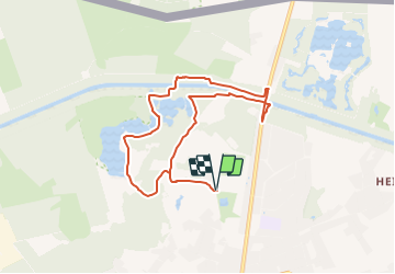
Tour Wandern von 7,3 km verfügbar auf Flandern, Limburg, Lommel. Diese Tour wird von Au fil de nos découvertes vorgeschlagen.
Beschreibung
🅿️ Départ et Parking: Le Soeverein, Sportveldenstraat 10 à 3920 Lommel
Le panneau des promenades se trouve en face du parking. Là où se trouvent des bancs.
⚠️ Petit conseil : prenez une photo des plans, car au 30/07, les circuits ont été modifiés en raison du covid 19.
Suivre la balise « rond jaune » 🟡
Pour rejoindre cette balise, il faut suivre la balise rouge 🔺 au départ du panneau regroupant toutes les promenades. Et lorsque vous arriverez sur la balise jaune, c’est de cet endroit que la boucle commence.
D’autres promenades sont possibles (voir photo du panneau)
😱 De la tour d’observation, vous aurez une magnifique vue à 360 degrés. Il faudra gravir 140 marches pour profiter de ce beau spectacle ! 🎉🎉
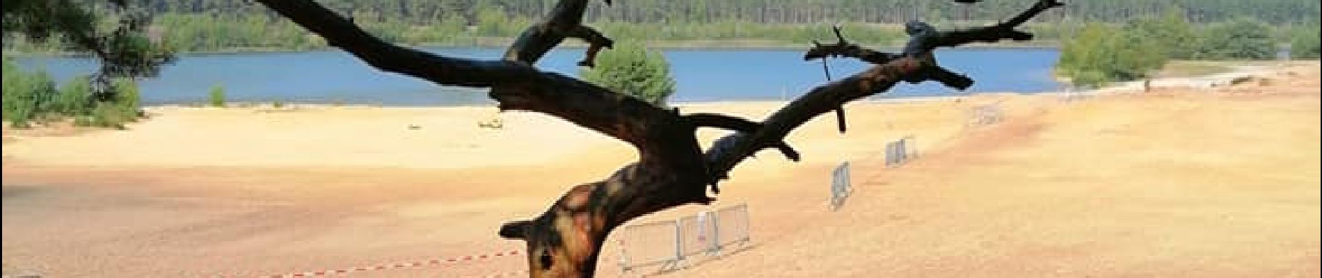
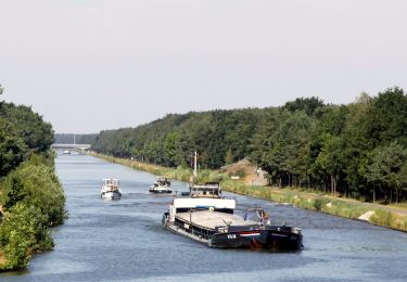
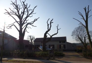
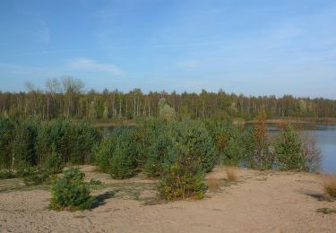
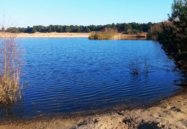
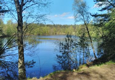
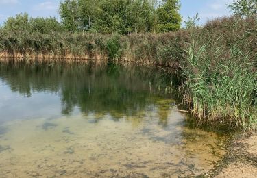
Vous passerez par de nombreux décors, les dunes de sable, les lacs, la forêt, le canal.. 😍
Cet endroit est très calme, très vaste et peu fréquenté (nous n’avons croisé quasiment personne !)
La baignade y est interdite. 🚫
Très grande plaine de jeux à proximité du parking. (derrière la piscine)
Plusieurs endroits pour pic-niquer sur la promenade. 🍴🥪
Chiens autorisés en laisse. 🐩🐶🐕
Convient pour les enfants. (il y a une promenade spéciale pour eux) 👱👱♂️
Ne convient pas pour les poussettes car il faut rouler dans du sable par moment. 👶
Il y a de nombreuses possibilités de ballades à vélo.
Ort
Kommentare
Touren in der Umgebung
![Tour Zu Fuß Lommel - Heuvelse Heide Groene rechthoek - Photo](https://media.geolcdn.com/t/375/260/b69f1859-9567-4db0-9bc6-29a1f9baf513.jpeg&format=jpg&maxdim=2)
![Zu Fuß Zu Fuß](https://static1.geolcdn.com/sitytour/trail-icons/100.png)
Zu Fuß
![](/images/other/stat-length.png)
![](https://static1.geolcdn.com/siteimages/upload/files/16400158638029165_repeat_loop_refresh_sync_direction_icon.png)
![Tour Zu Fuß Lommel - Heuvelse Heide Oranje bol - Photo](https://media.geolcdn.com/t/375/260/d619256e-abf9-4225-a41a-a8b43d797f6a.jpeg&format=jpg&maxdim=2)
![Zu Fuß Zu Fuß](https://static1.geolcdn.com/sitytour/trail-icons/100.png)
Zu Fuß
![](/images/other/stat-length.png)
![](https://static1.geolcdn.com/siteimages/upload/files/16400158638029165_repeat_loop_refresh_sync_direction_icon.png)
![Tour Zu Fuß Lommel - Heuvelse Heide Rode driehoek - Photo](https://media.geolcdn.com/t/375/260/d619256e-abf9-4225-a41a-a8b43d797f6a.jpeg&format=jpg&maxdim=2)
![Zu Fuß Zu Fuß](https://static1.geolcdn.com/sitytour/trail-icons/100.png)
Zu Fuß
![](/images/other/stat-length.png)
![](https://static1.geolcdn.com/siteimages/upload/files/16400158638029165_repeat_loop_refresh_sync_direction_icon.png)
![Tour Zu Fuß Lommel - Sahara Oranje bol - Photo](https://media.geolcdn.com/t/375/260/989458f3-9af0-4931-91a5-73604efbda81.jpeg&format=jpg&maxdim=2)
![Zu Fuß Zu Fuß](https://static1.geolcdn.com/sitytour/trail-icons/100.png)
Zu Fuß
![](/images/other/stat-length.png)
![](https://static1.geolcdn.com/siteimages/upload/files/16400158638029165_repeat_loop_refresh_sync_direction_icon.png)
![Tour Zu Fuß Lommel - Sahara Rode driehoek - Photo](https://media.geolcdn.com/t/375/260/989458f3-9af0-4931-91a5-73604efbda81.jpeg&format=jpg&maxdim=2)
![Zu Fuß Zu Fuß](https://static1.geolcdn.com/sitytour/trail-icons/100.png)
Zu Fuß
![](/images/other/stat-length.png)
![](https://static1.geolcdn.com/siteimages/upload/files/16400158638029165_repeat_loop_refresh_sync_direction_icon.png)
![Tour Wandern Lommel - Sahara de lommel - Photo](https://media.geolcdn.com/t/375/260/6272e3ab-7eb4-4e95-a097-0f43838a2ba5.jpg&format=jpg&maxdim=2)
![Wandern Wandern](https://static1.geolcdn.com/sitytour/trail-icons/101.png)
Wandern
![](/images/other/stat-length.png)
![](https://static1.geolcdn.com/siteimages/upload/files/16400158638029165_repeat_loop_refresh_sync_direction_icon.png)
![Tour Wandern Lommel - CANI-RADO TOUR (boucle Sahara de Lommel) - Photo](https://media.geolcdn.com/t/375/260/43b4dfdb-84e4-4b6f-a04b-0e30221a2424.jpg&format=jpg&maxdim=2)
![Wandern Wandern](https://static1.geolcdn.com/sitytour/trail-icons/101.png)
Wandern
![](/images/other/stat-length.png)
![](https://static1.geolcdn.com/siteimages/upload/files/16400158638029165_repeat_loop_refresh_sync_direction_icon.png)
![Tour Wandern Lommel - Oranje route Lommelse Sahara - Photo](https://media.geolcdn.com/t/375/260/ext.jpg?maxdim=2&url=https%3A%2F%2Fstatic1.geolcdn.com%2Fsiteimages%2Fupload%2Ffiles%2F1553511878bg_sport_marche.png)
![Wandern Wandern](https://static1.geolcdn.com/sitytour/trail-icons/101.png)
Wandern
![](/images/other/stat-length.png)
![](https://static1.geolcdn.com/siteimages/upload/files/16400158638029165_repeat_loop_refresh_sync_direction_icon.png)
![Tour Wandern Lommel - Le Sahara de Lommel - Photo](https://media.geolcdn.com/t/375/260/4a3d6b33-5a98-48a1-99c1-c8e88d9d7e04.jpeg&format=jpg&maxdim=2)
![Wandern Wandern](https://static1.geolcdn.com/sitytour/trail-icons/101.png)
Wandern
![](/images/other/stat-length.png)
![](https://static1.geolcdn.com/siteimages/upload/files/16400158638029165_repeat_loop_refresh_sync_direction_icon.png)