![](/images/other/stat-length.png)
![Tour Wandern Lecci - Vallée del'Osu - Ospedale 2021 - Photo](https://media.geolcdn.com/t/1900/400/ext.pjpeg?maxdim=2&url=https%3A%2F%2Fstatic1.geolcdn.com%2Fsiteimages%2Fupload%2Ffiles%2F1553511878bg_sport_marche.png)
Vallée del'Osu - Ospedale 2021
philippenl
Benutzer
![Länge](/images/other/stat-length.png)
![Maximale Höhe](https://static1.geolcdn.com/siteimages/upload/files/1508320355ic_sort_altitude_max_24dp.png)
![Positive Höhendifferenz](https://static1.geolcdn.com/siteimages/upload/files/1508320355ic_sort_den_pos_24dp.png)
![Km-Effort](/images/other/stat-length.png)
![Min. Höhe](https://static1.geolcdn.com/siteimages/upload/files/1508320355ic_sort_altitude_min_24dp.png)
![Negative Höhendifferenz](https://static1.geolcdn.com/siteimages/upload/files/1508320355ic_sort_den_neg_24dp.png)
![Boucle](https://static1.geolcdn.com/siteimages/upload/files/16400158638029165_repeat_loop_refresh_sync_direction_icon.png)
![Wandern](https://static1.geolcdn.com/sitytour/trail-icons/101.png)
3h20
Schwierigkeit : Sehr schwierig
![Scannen Sie diesen QR-Code, um die Tour in der SityTrail-Anwendung zu öffnen](https://capi.geolives.com/qq0zvz2zws4bq2lad0pu/sitytour/trails/3031439/qr.png?size=200)
Kostenlosegpshiking-Anwendung
Über SityTrail
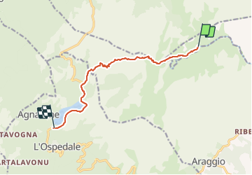
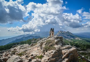
Tour Wandern von 10,6 km verfügbar auf Korsika, Südkorsika, Lecci. Diese Tour wird von philippenl vorgeschlagen.
Beschreibung
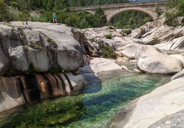
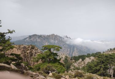
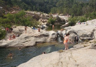
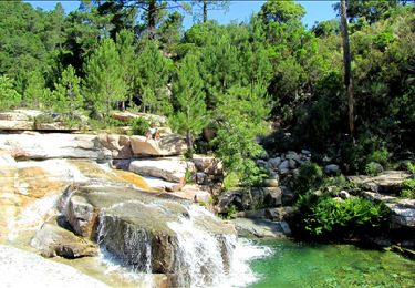
Sentier historique entre la vallée de l'Osu et le barrage de l'Ospedale via la Piscia di Gallu. Il date de plusieurs siècles. Merci à ceux qui l'ont récemment ré-ouvert et balisé ! Précisions :
1- Zone blanche sur la quasi totalité du parcours : aucun réseau GSM
2- L'arrivée à la hauteur de la cascade est particulièrement raide même si le sentier fait vaillamment des s. La carte IGN est fausse car le sentier de l'Osu débouche plus en amont de la piste de la cascade.
3- L'accès direct au réservoir Veolia en voiture (bonne piste forestière) n'est pas possible en saison chaude en raison d'une interdiction de circulation due aux risques d'incendie. Il permet de gagner 1h environ de marche à pied.
Ort
Kommentare
Touren in der Umgebung
![Tour Wandern Zonza - 2023-06-23 Balade Les trois piscines de Cavu - Photo](https://media.geolcdn.com/t/375/260/80ff9d7c-1f74-4902-8c44-ddec7e5d12ae.jpg&format=jpg&maxdim=2)
![Wandern Wandern](https://static1.geolcdn.com/sitytour/trail-icons/101.png)
Wandern
![](/images/other/stat-length.png)
![](https://static1.geolcdn.com/siteimages/upload/files/16400158638029165_repeat_loop_refresh_sync_direction_icon.png)
![Tour Wandern Zonza - Bocca d'Illarata vers bergerie de Luviu - Photo](https://media.geolcdn.com/t/375/260/b001c4ce-49f7-4ec0-a130-e18b6a6b6d79.jpg&format=jpg&maxdim=2)
![Wandern Wandern](https://static1.geolcdn.com/sitytour/trail-icons/101.png)
Wandern
![](/images/other/stat-length.png)
![](https://static1.geolcdn.com/siteimages/upload/files/16400158638029165_repeat_loop_refresh_sync_direction_icon.png)
![Tour Wandern Zonza - balade qui monte beaucoup mais belle - Photo](https://media.geolcdn.com/t/375/260/79322bd2-e860-4301-91ab-9ce75398a470.jpg&format=jpg&maxdim=2)
![Wandern Wandern](https://static1.geolcdn.com/sitytour/trail-icons/101.png)
Wandern
![](/images/other/stat-length.png)
![](https://static1.geolcdn.com/siteimages/upload/files/16400158638029165_repeat_loop_refresh_sync_direction_icon.png)
![Tour Andere Aktivitäten Zonza - monte calva bergerie de liviu - Photo](https://media.geolcdn.com/t/375/260/f6f8c06f-0b0d-44e2-b464-31146dceb503.jpg&format=jpg&maxdim=2)
![Andere Aktivitäten Andere Aktivitäten](https://static1.geolcdn.com/sitytour/trail-icons/900.png)
Andere Aktivitäten
![](/images/other/stat-length.png)
![](https://static1.geolcdn.com/siteimages/upload/files/16400158638029165_repeat_loop_refresh_sync_direction_icon.png)
![Tour Wandern Zonza - Les baignoires naturelles - Photo](https://media.geolcdn.com/t/375/260/ext.jpg?maxdim=2&url=https%3A%2F%2Fstatic1.geolcdn.com%2Fsiteimages%2Fupload%2Ffiles%2F1553511878bg_sport_marche.png)
![Wandern Wandern](https://static1.geolcdn.com/sitytour/trail-icons/101.png)
Wandern
![](/images/other/stat-length.png)
![](https://static1.geolcdn.com/siteimages/upload/files/16400158638029165_repeat_loop_refresh_sync_direction_icon.png)
![Tour Wandern Zonza - la rivière du Cavu - Photo](https://media.geolcdn.com/t/375/260/ext.jpg?maxdim=2&url=https%3A%2F%2Fservices.sitytrail.com%2FGeolivesWS%2FDownloadMedia.ashx%3FTrailID%3D199050%26Media%3D4dd712c9-7b8e-4c6d-b767-cea357b59154.jpg)
![Wandern Wandern](https://static1.geolcdn.com/sitytour/trail-icons/101.png)
Wandern
![](/images/other/stat-length.png)
![](https://static1.geolcdn.com/siteimages/upload/files/16400158638029165_repeat_loop_refresh_sync_direction_icon.png)
![Tour sport San-Gavino-di-Carbini - T - Photo](https://media.geolcdn.com/t/375/260/11e5f66b-f0cf-4650-a443-eb5bad93484a.jpg&format=jpg&maxdim=2)
sport
![](/images/other/stat-length.png)
![](https://static1.geolcdn.com/siteimages/upload/files/16400158638029165_repeat_loop_refresh_sync_direction_icon.png)
![Tour Wandern Zonza - Les trois fontaines - Photo](https://media.geolcdn.com/t/375/260/d2895e60-6206-4b20-a2c8-ac05013dde8b.jpg&format=jpg&maxdim=2)
![Wandern Wandern](https://static1.geolcdn.com/sitytour/trail-icons/101.png)
Wandern
![](/images/other/stat-length.png)
![](https://static1.geolcdn.com/siteimages/upload/files/16400158638029165_repeat_loop_refresh_sync_direction_icon.png)
![Tour Wandern Zonza - Monte Calva - Photo](https://media.geolcdn.com/t/375/260/90924935-0312-45a4-b7a1-fe799375ae5b.jpg&format=jpg&maxdim=2)
![Wandern Wandern](https://static1.geolcdn.com/sitytour/trail-icons/101.png)
Wandern
![](/images/other/stat-length.png)
![](https://static1.geolcdn.com/siteimages/upload/files/16400158638029165_repeat_loop_refresh_sync_direction_icon.png)