![](/images/other/stat-length.png)
![Tour Wandern Saint-Marcel-de-Félines - St Marcel de Felines - Photo](https://media.geolcdn.com/t/1900/400/ext.pjpeg?maxdim=2&url=https%3A%2F%2Fstatic1.geolcdn.com%2Fsiteimages%2Fupload%2Ffiles%2F1553511878bg_sport_marche.png)
St Marcel de Felines
mimi69670
Benutzer
![Länge](/images/other/stat-length.png)
Länge
9,2 km
![Maximale Höhe](https://static1.geolcdn.com/siteimages/upload/files/1508320355ic_sort_altitude_max_24dp.png)
Maximale Höhe
503 m
![Positive Höhendifferenz](https://static1.geolcdn.com/siteimages/upload/files/1508320355ic_sort_den_pos_24dp.png)
Positive Höhendifferenz
229 m
![Km-Effort](/images/other/stat-length.png)
Km-Effort
12,3 km
![Min. Höhe](https://static1.geolcdn.com/siteimages/upload/files/1508320355ic_sort_altitude_min_24dp.png)
Min. Höhe
405 m
![Negative Höhendifferenz](https://static1.geolcdn.com/siteimages/upload/files/1508320355ic_sort_den_neg_24dp.png)
Negative Höhendifferenz
230 m
![Boucle](https://static1.geolcdn.com/siteimages/upload/files/16400158638029165_repeat_loop_refresh_sync_direction_icon.png)
Boucle
Ja
Erstellungsdatum :
2021-12-08 13:04:42.214
Letzte Änderung :
2021-12-08 15:37:40.203
![Wandern](https://static1.geolcdn.com/sitytour/trail-icons/101.png)
2h32
Schwierigkeit : Einfach
![Scannen Sie diesen QR-Code, um die Tour in der SityTrail-Anwendung zu öffnen](https://capi.geolives.com/qq0zvz2zws4bq2lad0pu/sitytour/trails/3021679/qr.png?size=200)
Kostenlosegpshiking-Anwendung
Über SityTrail
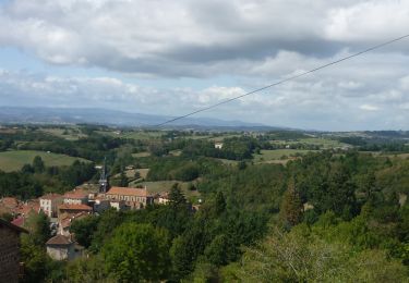
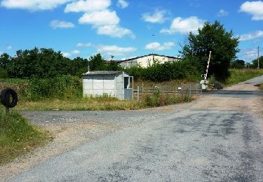
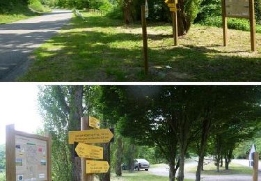
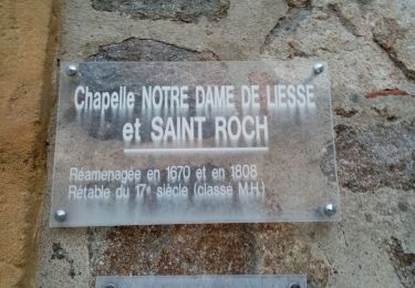
Tour Wandern von 9,2 km verfügbar auf Auvergne-Rhone-Alpen, Loire, Saint-Marcel-de-Félines. Diese Tour wird von mimi69670 vorgeschlagen.
Beschreibung
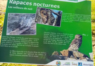
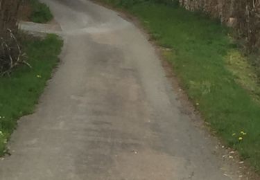
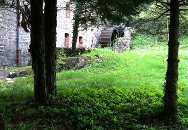
Départ devant l'église de St Marcel de Félines, rando autour de St Marcel de Félines, la grotte de Félines
Ort
Land:
France
Region :
Auvergne-Rhone-Alpen
Abteilung/Provinz :
Loire
Kommune :
Saint-Marcel-de-Félines
Standort:
Unknown
Gehen Sie:(Dec)
Gehen Sie:(UTM)
592475 ; 5080166 (31T) N.
Kommentare
Touren in der Umgebung
![Wandern Wandern](https://static1.geolcdn.com/sitytour/trail-icons/101.png)
Néronde
Wandern
Medium
(1)
Néronde,
Auvergne-Rhone-Alpen,
Loire,
France
![](/images/other/stat-length.png)
11,4 km | 15,3 km-effort
4h 12min
![](https://static1.geolcdn.com/siteimages/upload/files/16400158638029165_repeat_loop_refresh_sync_direction_icon.png)
Ja
![Tour Wandern Balbigny - Autour des Gorges de la Loire - PR N° 2 : Le Funiculaire de Biesse - Les Chessieux - Photo](https://media.geolcdn.com/t/375/260/ext.jpg?maxdim=2&url=https%3A%2F%2Fservices.sitytrail.com%2FGeolivesWS%2FDownloadMedia.ashx%3FTrailID%3D215160%26Media%3D15762_6.jpg)
![Wandern Wandern](https://static1.geolcdn.com/sitytour/trail-icons/101.png)
Autour des Gorges de la Loire - PR N° 2 : Le Funiculaire de Biesse - Les Ches...
Wandern
Medium
(1)
Balbigny,
Auvergne-Rhone-Alpen,
Loire,
France
![](/images/other/stat-length.png)
8,7 km | 11 km-effort
3h 0min
![](https://static1.geolcdn.com/siteimages/upload/files/16400158638029165_repeat_loop_refresh_sync_direction_icon.png)
Ja
![Tour Wandern Pinay - Autour des Gorges de la Loire - GR Pays N° 5 : De la Digue à La Vourdiat - La Digue de Pinay - Photo](https://media.geolcdn.com/t/375/260/ext.jpg?maxdim=2&url=https%3A%2F%2Fservices.sitytrail.com%2FGeolivesWS%2FDownloadMedia.ashx%3FTrailID%3D215012%26Media%3D15578_6.jpg)
![Wandern Wandern](https://static1.geolcdn.com/sitytour/trail-icons/101.png)
Autour des Gorges de la Loire - GR Pays N° 5 : De la Digue à La Vourdiat - La...
Wandern
Schwierig
(1)
Pinay,
Auvergne-Rhone-Alpen,
Loire,
France
![](/images/other/stat-length.png)
18 km | 24 km-effort
4h 0min
![](https://static1.geolcdn.com/siteimages/upload/files/16400158638029165_repeat_loop_refresh_sync_direction_icon.png)
Ja
![Tour Wandern Néronde - Néronde - Pouilly les Feurs - Photo](https://media.geolcdn.com/t/375/260/ext.jpg?maxdim=2&url=https%3A%2F%2Fstatic1.geolcdn.com%2Fsiteimages%2Fupload%2Ffiles%2F1553511878bg_sport_marche.png)
![Wandern Wandern](https://static1.geolcdn.com/sitytour/trail-icons/101.png)
Néronde - Pouilly les Feurs
Wandern
Sehr schwierig
(1)
Néronde,
Auvergne-Rhone-Alpen,
Loire,
France
![](/images/other/stat-length.png)
18,4 km | 25 km-effort
5h 46min
![](https://static1.geolcdn.com/siteimages/upload/files/16400158638029165_repeat_loop_refresh_sync_direction_icon.png)
Ja
![Tour Wandern Saint-Just-la-Pendue - St Just la Pendue, départ à la chapelle - Photo](https://media.geolcdn.com/t/375/260/d9e557db-285e-474a-a80e-c32ca6be6af3.jpg&format=jpg&maxdim=2)
![Wandern Wandern](https://static1.geolcdn.com/sitytour/trail-icons/101.png)
St Just la Pendue, départ à la chapelle
Wandern
Einfach
Saint-Just-la-Pendue,
Auvergne-Rhone-Alpen,
Loire,
France
![](/images/other/stat-length.png)
10,1 km | 13,1 km-effort
2h 43min
![](https://static1.geolcdn.com/siteimages/upload/files/16400158638029165_repeat_loop_refresh_sync_direction_icon.png)
Ja
![Tour Wandern Saint-Marcel-de-Félines - rando à partir de St Marcel les Felines - Photo](https://media.geolcdn.com/t/375/260/25de8710-609c-4277-bb5d-14bd81d5616d.jpg&format=jpg&maxdim=2)
![Wandern Wandern](https://static1.geolcdn.com/sitytour/trail-icons/101.png)
rando à partir de St Marcel les Felines
Wandern
Medium
Saint-Marcel-de-Félines,
Auvergne-Rhone-Alpen,
Loire,
France
![](/images/other/stat-length.png)
12,7 km | 16,6 km-effort
3h 46min
![](https://static1.geolcdn.com/siteimages/upload/files/16400158638029165_repeat_loop_refresh_sync_direction_icon.png)
Ja
![Tour Wandern Balbigny - Départ de Chessieu, PR2. funiculaire - Photo](https://media.geolcdn.com/t/375/260/57b0fbfe-9088-4ef9-b2c4-fddcd14b4b5d.jpg&format=jpg&maxdim=2)
![Wandern Wandern](https://static1.geolcdn.com/sitytour/trail-icons/101.png)
Départ de Chessieu, PR2. funiculaire
Wandern
Medium
Balbigny,
Auvergne-Rhone-Alpen,
Loire,
France
![](/images/other/stat-length.png)
8,8 km | 11,2 km-effort
2h 25min
![](https://static1.geolcdn.com/siteimages/upload/files/16400158638029165_repeat_loop_refresh_sync_direction_icon.png)
Ja
![Tour Wandern Néronde - Neronde vers Chapelle Notre Damem - Photo](https://media.geolcdn.com/t/375/260/1736485a-ae7b-45e4-b3f7-5e95bea0e1e5.jpg&format=jpg&maxdim=2)
![Wandern Wandern](https://static1.geolcdn.com/sitytour/trail-icons/101.png)
Neronde vers Chapelle Notre Damem
Wandern
Medium
Néronde,
Auvergne-Rhone-Alpen,
Loire,
France
![](/images/other/stat-length.png)
6,4 km | 8,6 km-effort
2h 38min
![](https://static1.geolcdn.com/siteimages/upload/files/16400158638029165_repeat_loop_refresh_sync_direction_icon.png)
Nein
![Tour Wandern Saint-Marcel-de-Félines - St Marcel de Félines - Photo](https://media.geolcdn.com/t/375/260/ext.jpg?maxdim=2&url=https%3A%2F%2Fservices.sitytrail.com%2FGeolivesWS%2FDownloadMedia.ashx%3FTrailID%3D369342%26Media%3D20141007152007.jpg)
![Wandern Wandern](https://static1.geolcdn.com/sitytour/trail-icons/101.png)
St Marcel de Félines
Wandern
Medium
Saint-Marcel-de-Félines,
Auvergne-Rhone-Alpen,
Loire,
France
![](/images/other/stat-length.png)
10,5 km | 14,3 km-effort
3h 1min
![](https://static1.geolcdn.com/siteimages/upload/files/16400158638029165_repeat_loop_refresh_sync_direction_icon.png)
Ja