![](/images/other/stat-length.png)
![Tour Zu Fuß Houyet - HOUYET 3 BOUCLES - Photo](https://media.geolcdn.com/t/1900/400/ext.pjpeg?maxdim=2&url=https%3A%2F%2Fstatic1.geolcdn.com%2Fsiteimages%2Fupload%2Ffiles%2F1545311037marcheuse_200dpi.jpg)
HOUYET 3 BOUCLES
cobut.jp@gmail.com
Benutzer
![Länge](/images/other/stat-length.png)
Länge
20 km
![Maximale Höhe](https://static1.geolcdn.com/siteimages/upload/files/1508320355ic_sort_altitude_max_24dp.png)
Maximale Höhe
279 m
![Positive Höhendifferenz](https://static1.geolcdn.com/siteimages/upload/files/1508320355ic_sort_den_pos_24dp.png)
Positive Höhendifferenz
510 m
![Km-Effort](/images/other/stat-length.png)
Km-Effort
27 km
![Min. Höhe](https://static1.geolcdn.com/siteimages/upload/files/1508320355ic_sort_altitude_min_24dp.png)
Min. Höhe
116 m
![Negative Höhendifferenz](https://static1.geolcdn.com/siteimages/upload/files/1508320355ic_sort_den_neg_24dp.png)
Negative Höhendifferenz
519 m
![Boucle](https://static1.geolcdn.com/siteimages/upload/files/16400158638029165_repeat_loop_refresh_sync_direction_icon.png)
Boucle
Ja
Erstellungsdatum :
2021-12-02 11:10:20.347
Letzte Änderung :
2021-12-02 11:18:52.995
![Zu Fuß](https://static1.geolcdn.com/sitytour/trail-icons/100.png)
6h05
Schwierigkeit : Medium
![Scannen Sie diesen QR-Code, um die Tour in der SityTrail-Anwendung zu öffnen](https://capi.geolives.com/qq0zvz2zws4bq2lad0pu/sitytour/trails/3017368/qr.png?size=200)
Kostenlosegpshiking-Anwendung
Über SityTrail
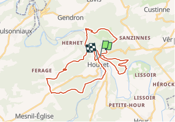
Tour Zu Fuß von 20 km verfügbar auf Wallonien, Namur, Houyet. Diese Tour wird von cobut.jp@gmail.com vorgeschlagen.
Beschreibung
3 BOUCLES AUTOUR DE HOUYET 1 PARC D'ARDENNE LOSANGE BLEU . 2 BOIS DU TCHERO LOSANGE ROUGE . 3 FOND D'IROU TRIANGLE VERT . TRES BELLES RANDONNEES.
Ort
Land:
Belgium
Region :
Wallonien
Abteilung/Provinz :
Namur
Kommune :
Houyet
Standort:
Unknown
Gehen Sie:(Dec)
Gehen Sie:(UTM)
643342 ; 5561743 (31U) N.
Kommentare
Touren in der Umgebung
![Tour Wandern Houyet - Nature - The Payenne trail (Houyet) - Photo](https://media.geolcdn.com/t/375/260/ext.jpg?maxdim=2&url=https%3A%2F%2Fservices.sitytrail.com%2FGeolivesWS%2FDownloadMedia.ashx%3FTrailID%3D247221%26Media%3D4a1116e4-3cc3-4f81-a279-87cb261b0cef.jpg)
![Wandern Wandern](https://static1.geolcdn.com/sitytour/trail-icons/101.png)
Nature - The Payenne trail (Houyet)
Wandern
Schwierig
(5)
Houyet,
Wallonien,
Namur,
Belgium
![](/images/other/stat-length.png)
14,3 km | 19 km-effort
4h 18min
![](https://static1.geolcdn.com/siteimages/upload/files/16400158638029165_repeat_loop_refresh_sync_direction_icon.png)
Ja
![Tour Wandern Houyet - Nature - Royal Park walk - Houyet - Photo](https://media.geolcdn.com/t/375/260/ext.jpg?maxdim=2&url=https%3A%2F%2Fservices.sitytrail.com%2FGeolivesWS%2FDownloadMedia.ashx%3FTrailID%3D193546%26Media%3D0a2a8593-cf69-475f-a9b0-b2a4af4f959b.jpg)
![Wandern Wandern](https://static1.geolcdn.com/sitytour/trail-icons/101.png)
Nature - Royal Park walk - Houyet
Wandern
Schwierig
(14)
Houyet,
Wallonien,
Namur,
Belgium
![](/images/other/stat-length.png)
5,7 km | 7,8 km-effort
1h 47min
![](https://static1.geolcdn.com/siteimages/upload/files/16400158638029165_repeat_loop_refresh_sync_direction_icon.png)
Ja
![Tour Wandern Houyet - Houyet - Pî-sinte po tortos - Walk for everyone - On foot, by bicycle, on horseback, wheelchair accessible - Photo](https://media.geolcdn.com/t/375/260/ext.jpg?maxdim=2&url=https%3A%2F%2Fservices.sitytrail.com%2FGeolivesWS%2FDownloadMedia.ashx%3FTrailID%3D193539%26Media%3D6b85272b-deee-4a79-9526-05b6bf74491c.jpg)
![Wandern Wandern](https://static1.geolcdn.com/sitytour/trail-icons/101.png)
Houyet - Pî-sinte po tortos - Walk for everyone - On foot, by bicycle, on ho...
Wandern
(6)
Houyet,
Wallonien,
Namur,
Belgium
![](/images/other/stat-length.png)
4,3 km | 4,9 km-effort
1h 0min
![](https://static1.geolcdn.com/siteimages/upload/files/16400158638029165_repeat_loop_refresh_sync_direction_icon.png)
Ja
![Tour Wandern Houyet - La Lesse, Natura 2000 - Des sites qui valent le détour, Na07 - Photo](https://media.geolcdn.com/t/375/260/ext.jpg?maxdim=2&url=https%3A%2F%2Fservices.sitytrail.com%2FGeolivesWS%2FDownloadMedia.ashx%3FTrailID%3D188163%26Media%3Df0b29f0e-e19a-4fa8-a869-5ab27b1769d7.JPG)
![Wandern Wandern](https://static1.geolcdn.com/sitytour/trail-icons/101.png)
La Lesse, Natura 2000 - Des sites qui valent le détour, Na07
Wandern
Schwierig
(9)
Houyet,
Wallonien,
Namur,
Belgium
![](/images/other/stat-length.png)
8,8 km | 11,5 km-effort
2h 33min
![](https://static1.geolcdn.com/siteimages/upload/files/16400158638029165_repeat_loop_refresh_sync_direction_icon.png)
Ja
![Tour Wandern Houyet - RB-Na-05 Hauts lieux de la basse Lesse - Photo](https://media.geolcdn.com/t/375/260/ext.jpg?maxdim=2&url=https%3A%2F%2Fservices.sitytrail.com%2FGeolivesWS%2FDownloadMedia.ashx%3FTrailID%3D179631%26Media%3D95d7547e-2b07-4681-8a2a-4a37901ae9c7.jpg)
![Wandern Wandern](https://static1.geolcdn.com/sitytour/trail-icons/101.png)
RB-Na-05 Hauts lieux de la basse Lesse
Wandern
Medium
(9)
Houyet,
Wallonien,
Namur,
Belgium
![](/images/other/stat-length.png)
24 km | 31 km-effort
6h 33min
![](https://static1.geolcdn.com/siteimages/upload/files/16400158638029165_repeat_loop_refresh_sync_direction_icon.png)
Ja
![Tour Wandern Houyet - Nature - Houyet, a royal municipality - Photo](https://media.geolcdn.com/t/375/260/ext.jpg?maxdim=2&url=https%3A%2F%2Fservices.sitytrail.com%2FGeolivesWS%2FDownloadMedia.ashx%3FTrailID%3D166040%26Media%3D0a2a8593-cf69-475f-a9b0-b2a4af4f959b.jpg)
![Wandern Wandern](https://static1.geolcdn.com/sitytour/trail-icons/101.png)
Nature - Houyet, a royal municipality
Wandern
Schwierig
(14)
Houyet,
Wallonien,
Namur,
Belgium
![](/images/other/stat-length.png)
8,3 km | 11,5 km-effort
2h 33min
![](https://static1.geolcdn.com/siteimages/upload/files/16400158638029165_repeat_loop_refresh_sync_direction_icon.png)
Ja
![Tour Wandern Houyet - Nature - Between Hour & Wanlin - Photo](https://media.geolcdn.com/t/375/260/ext.jpg?maxdim=2&url=https%3A%2F%2Fservices.sitytrail.com%2FGeolivesWS%2FDownloadMedia.ashx%3FTrailID%3D166017%26Media%3D2c14efcd-5b67-4689-9c33-da59ccf6bde5.jpg)
![Wandern Wandern](https://static1.geolcdn.com/sitytour/trail-icons/101.png)
Nature - Between Hour & Wanlin
Wandern
Einfach
(6)
Houyet,
Wallonien,
Namur,
Belgium
![](/images/other/stat-length.png)
7,6 km | 9,2 km-effort
2h 4min
![](https://static1.geolcdn.com/siteimages/upload/files/16400158638029165_repeat_loop_refresh_sync_direction_icon.png)
Ja
![Tour Wandern Houyet - RB-Na-05 Raccourci 1 - Hauts lieux de la basse Lesse - Photo](https://media.geolcdn.com/t/375/260/ext.jpg?maxdim=2&url=https%3A%2F%2Fservices.sitytrail.com%2FGeolivesWS%2FDownloadMedia.ashx%3FTrailID%3D213753%26Media%3D8bab1d47-4651-4050-8b88-78bf90d52eb5.jpg)
![Wandern Wandern](https://static1.geolcdn.com/sitytour/trail-icons/101.png)
RB-Na-05 Raccourci 1 - Hauts lieux de la basse Lesse
Wandern
Einfach
(5)
Houyet,
Wallonien,
Namur,
Belgium
![](/images/other/stat-length.png)
21 km | 26 km-effort
5h 37min
![](https://static1.geolcdn.com/siteimages/upload/files/16400158638029165_repeat_loop_refresh_sync_direction_icon.png)
Ja
![Tour Wandern Houyet - Nature & heritage in Celles, one of the Most Beautiful Villages of Wallonia - Photo](https://media.geolcdn.com/t/375/260/ac9d387c-3f8d-401d-bffe-044b71ce3eff.jpg&format=jpg&maxdim=2)
![Wandern Wandern](https://static1.geolcdn.com/sitytour/trail-icons/101.png)
Nature & heritage in Celles, one of the Most Beautiful Villages of Wallonia
Wandern
Medium
(6)
Houyet,
Wallonien,
Namur,
Belgium
![](/images/other/stat-length.png)
9,6 km | 12,7 km-effort
2h 52min
![](https://static1.geolcdn.com/siteimages/upload/files/16400158638029165_repeat_loop_refresh_sync_direction_icon.png)
Ja