![](/images/other/stat-length.png)
![Tour Wandern Chamarande - 2021-11-26_19h35m21_SityTrail - 2278531 - chamarandexlardy - Photo](https://media.geolcdn.com/t/1900/400/ext.pjpeg?maxdim=2&url=https%3A%2F%2Fstatic1.geolcdn.com%2Fsiteimages%2Fupload%2Ffiles%2F1553511878bg_sport_marche.png)
2021-11-26_19h35m21_SityTrail - 2278531 - chamarandexlardy
jpcccb
Benutzer
![Länge](/images/other/stat-length.png)
Länge
14,4 km
![Maximale Höhe](https://static1.geolcdn.com/siteimages/upload/files/1508320355ic_sort_altitude_max_24dp.png)
Maximale Höhe
151 m
![Positive Höhendifferenz](https://static1.geolcdn.com/siteimages/upload/files/1508320355ic_sort_den_pos_24dp.png)
Positive Höhendifferenz
228 m
![Km-Effort](/images/other/stat-length.png)
Km-Effort
17,4 km
![Min. Höhe](https://static1.geolcdn.com/siteimages/upload/files/1508320355ic_sort_altitude_min_24dp.png)
Min. Höhe
58 m
![Negative Höhendifferenz](https://static1.geolcdn.com/siteimages/upload/files/1508320355ic_sort_den_neg_24dp.png)
Negative Höhendifferenz
229 m
![Boucle](https://static1.geolcdn.com/siteimages/upload/files/16400158638029165_repeat_loop_refresh_sync_direction_icon.png)
Boucle
Nein
Erstellungsdatum :
2021-11-26 18:35:21.328
Letzte Änderung :
2023-05-09 13:01:24.797
![Wandern](https://static1.geolcdn.com/sitytour/trail-icons/101.png)
4h10
Schwierigkeit : Schwierig
![Scannen Sie diesen QR-Code, um die Tour in der SityTrail-Anwendung zu öffnen](https://capi.geolives.com/qq0zvz2zws4bq2lad0pu/sitytour/trails/3013302/qr.png?size=200)
Kostenlosegpshiking-Anwendung
Über SityTrail
Tour Wandern von 14,4 km verfügbar auf Île-de-France, Essonne, Chamarande. Diese Tour wird von jpcccb vorgeschlagen.
Beschreibung
Parc de Chamarande, château, belvédère, GR 655, Gillevoisin, bois de Pernaison, pierre levée, château du Mesnil Voisin, la Juine.
Ort
Land:
France
Region :
Île-de-France
Abteilung/Provinz :
Essonne
Kommune :
Chamarande
Standort:
Unknown
Gehen Sie:(Dec)
Gehen Sie:(UTM)
442108 ; 5373768 (31U) N.
Kommentare
Touren in der Umgebung
![Tour Wandern Lardy - Lardy - Chamarande -F - Photo](https://media.geolcdn.com/t/375/260/ext.jpg?maxdim=2&url=https%3A%2F%2Fservices.sitytrail.com%2FGeolivesWS%2FDownloadMedia.ashx%3FTrailID%3D274259%26Media%3Dfix__20140504142726.jpg)
![Wandern Wandern](https://static1.geolcdn.com/sitytour/trail-icons/101.png)
Lardy - Chamarande -F
Wandern
Medium
(2)
Lardy,
Île-de-France,
Essonne,
France
![](/images/other/stat-length.png)
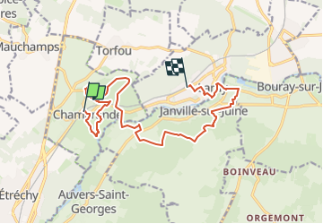
18,3 km | 22 km-effort
4h 44min
![](https://static1.geolcdn.com/siteimages/upload/files/16400158638029165_repeat_loop_refresh_sync_direction_icon.png)
Ja
![Tour Wandern Saint-Sulpice-de-Favières - Les Pétales de Souzy - Photo](https://media.geolcdn.com/t/375/260/ext.jpg?maxdim=2&url=https%3A%2F%2Fservices.sitytrail.com%2FGeolivesWS%2FDownloadMedia.ashx%3FTrailID%3D110217%26Media%3D5477_1.jpg)
![Wandern Wandern](https://static1.geolcdn.com/sitytour/trail-icons/101.png)
Les Pétales de Souzy
Wandern
Schwierig
(1)
Saint-Sulpice-de-Favières,
Île-de-France,
Essonne,
France
![](/images/other/stat-length.png)
23 km | 29 km-effort
4h 49min
![](https://static1.geolcdn.com/siteimages/upload/files/16400158638029165_repeat_loop_refresh_sync_direction_icon.png)
Ja
![Tour Wandern Lardy - Autour de Lardy par la Pierre levée de Janville sur Juine - Photo](https://media.geolcdn.com/t/375/260/ext.jpg?maxdim=2&url=https%3A%2F%2Fservices.sitytrail.com%2FGeolivesWS%2FDownloadMedia.ashx%3FTrailID%3D110136%26Media%3D5334_1.jpg)
![Wandern Wandern](https://static1.geolcdn.com/sitytour/trail-icons/101.png)
Autour de Lardy par la Pierre levée de Janville sur Juine
Wandern
Schwierig
(1)
Lardy,
Île-de-France,
Essonne,
France
![](/images/other/stat-length.png)
24 km | 29 km-effort
4h 49min
![](https://static1.geolcdn.com/siteimages/upload/files/16400158638029165_repeat_loop_refresh_sync_direction_icon.png)
Ja
![Tour Zu Fuß Étréchy - Linéaire Etrechy - Dourdan - Photo](https://media.geolcdn.com/t/375/260/6933a6b2-3858-4fb1-ab0c-7f731489899d.jpg&format=jpg&maxdim=2)
![Zu Fuß Zu Fuß](https://static1.geolcdn.com/sitytour/trail-icons/100.png)
Linéaire Etrechy - Dourdan
Zu Fuß
Medium
Étréchy,
Île-de-France,
Essonne,
France
![](/images/other/stat-length.png)
26 km | 31 km-effort
7h 3min
![](https://static1.geolcdn.com/siteimages/upload/files/16400158638029165_repeat_loop_refresh_sync_direction_icon.png)
Nein
![Tour Zu Fuß Saint-Sulpice-de-Favières - Boucle 18 km St Sulpice de Favières - Photo](https://media.geolcdn.com/t/375/260/d7c57897-6d36-438c-b5b4-66e9a4d71ed2.jpg&format=jpg&maxdim=2)
![Zu Fuß Zu Fuß](https://static1.geolcdn.com/sitytour/trail-icons/100.png)
Boucle 18 km St Sulpice de Favières
Zu Fuß
Medium
Saint-Sulpice-de-Favières,
Île-de-France,
Essonne,
France
![](/images/other/stat-length.png)
18 km | 22 km-effort
4h 59min
![](https://static1.geolcdn.com/siteimages/upload/files/16400158638029165_repeat_loop_refresh_sync_direction_icon.png)
Ja
![Tour Wandern Chamarande - bois de belvedere au depart de chamarande - Photo](https://media.geolcdn.com/t/375/260/ext.jpg?maxdim=2&url=https%3A%2F%2Fstatic1.geolcdn.com%2Fsiteimages%2Fupload%2Ffiles%2F1553511878bg_sport_marche.png)
![Wandern Wandern](https://static1.geolcdn.com/sitytour/trail-icons/101.png)
bois de belvedere au depart de chamarande
Wandern
Schwierig
(1)
Chamarande,
Île-de-France,
Essonne,
France
![](/images/other/stat-length.png)
12,6 km | 17,2 km-effort
3h 54min
![](https://static1.geolcdn.com/siteimages/upload/files/16400158638029165_repeat_loop_refresh_sync_direction_icon.png)
Ja
![Tour Zu Fuß Lardy - Boucle Lardy par Pascale - Photo](https://media.geolcdn.com/t/375/260/fcd0ce26-70c7-4c63-8ed6-22b96bedd69d.jpg&format=jpg&maxdim=2)
![Zu Fuß Zu Fuß](https://static1.geolcdn.com/sitytour/trail-icons/100.png)
Boucle Lardy par Pascale
Zu Fuß
Einfach
Lardy,
Île-de-France,
Essonne,
France
![](/images/other/stat-length.png)
20 km | 25 km-effort
5h 36min
![](https://static1.geolcdn.com/siteimages/upload/files/16400158638029165_repeat_loop_refresh_sync_direction_icon.png)
Ja
![Tour Zu Fuß Auvers-Saint-Georges - Au grès de la Juine - Photo](https://media.geolcdn.com/t/375/260/72c017b2-4cbc-4eae-9d9f-90478ed2d91b.jpeg&format=jpg&maxdim=2)
![Zu Fuß Zu Fuß](https://static1.geolcdn.com/sitytour/trail-icons/100.png)
Au grès de la Juine
Zu Fuß
Medium
Auvers-Saint-Georges,
Île-de-France,
Essonne,
France
![](/images/other/stat-length.png)
22 km | 27 km-effort
6h 10min
![](https://static1.geolcdn.com/siteimages/upload/files/16400158638029165_repeat_loop_refresh_sync_direction_icon.png)
Nein
![Tour Wandern Étréchy - Boucle de 2 jours au départ d'Etréchy via Etampes Chalo St Mars - Photo](https://media.geolcdn.com/t/375/260/ext.jpg?maxdim=2&url=https%3A%2F%2Fstatic1.geolcdn.com%2Fsiteimages%2Fupload%2Ffiles%2F1553511878bg_sport_marche.png)
![Wandern Wandern](https://static1.geolcdn.com/sitytour/trail-icons/101.png)
Boucle de 2 jours au départ d'Etréchy via Etampes Chalo St Mars
Wandern
Sehr schwierig
(1)
Étréchy,
Île-de-France,
Essonne,
France
![](/images/other/stat-length.png)
42 km | 51 km-effort
11h 28min
![](https://static1.geolcdn.com/siteimages/upload/files/16400158638029165_repeat_loop_refresh_sync_direction_icon.png)
Ja