![](/images/other/stat-length.png)
Circuit des villages
houbart
Benutzer
![Länge](/images/other/stat-length.png)
Länge
8,2 km
![Maximale Höhe](https://static1.geolcdn.com/siteimages/upload/files/1508320355ic_sort_altitude_max_24dp.png)
Maximale Höhe
220 m
![Positive Höhendifferenz](https://static1.geolcdn.com/siteimages/upload/files/1508320355ic_sort_den_pos_24dp.png)
Positive Höhendifferenz
180 m
![Km-Effort](/images/other/stat-length.png)
Km-Effort
10,6 km
![Min. Höhe](https://static1.geolcdn.com/siteimages/upload/files/1508320355ic_sort_altitude_min_24dp.png)
Min. Höhe
120 m
![Negative Höhendifferenz](https://static1.geolcdn.com/siteimages/upload/files/1508320355ic_sort_den_neg_24dp.png)
Negative Höhendifferenz
179 m
![Boucle](https://static1.geolcdn.com/siteimages/upload/files/16400158638029165_repeat_loop_refresh_sync_direction_icon.png)
Boucle
Ja
Erstellungsdatum :
2019-03-28 15:47:38.3
Letzte Änderung :
2019-03-28 15:47:38.359
![Wandern](https://static1.geolcdn.com/sitytour/trail-icons/101.png)
2h06
Schwierigkeit : Medium
![Scannen Sie diesen QR-Code, um die Tour in der SityTrail-Anwendung zu öffnen](https://capi.geolives.com/qq0zvz2zws4bq2lad0pu/sitytour/trails/301319/qr.png?size=200)
Kostenlosegpshiking-Anwendung
Über SityTrail
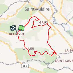
Tour Wandern von 8,2 km verfügbar auf Neu-Aquitanien, Corrèze, Saint-Aulaire. Diese Tour wird von houbart vorgeschlagen.
Beschreibung
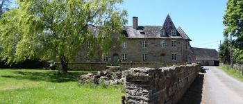
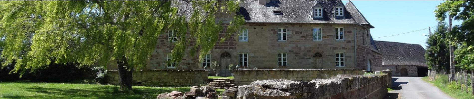
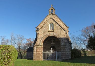
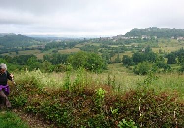
Départ Mairie de Saint-Aulaire. Petits villages pittoresques et jolis points de vue. Au mois de mai, le chemin bordé de cerisiers offre un petit goûter fort sympathique.
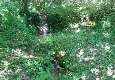
Par temps humide, le chemin qui remonte vers Gorbas est détrempé, prévoir chaussures étanches.
Ort
Land:
France
Region :
Neu-Aquitanien
Abteilung/Provinz :
Corrèze
Kommune :
Saint-Aulaire
Standort:
Unknown
Gehen Sie:(Dec)
Gehen Sie:(UTM)
373272 ; 5010619 (31T) N.
Kommentare
Touren in der Umgebung
![Tour Wandern Ayen - Ayen-160621 - CoteauxAyenSud - Photo](https://media.geolcdn.com/t/375/260/ext.jpg?maxdim=2&url=https%3A%2F%2Fservices.sitytrail.com%2FGeolivesWS%2FDownloadMedia.ashx%3FTrailID%3D587734%26Media%3Dfix__20160621100049.jpg)
![Wandern Wandern](https://static1.geolcdn.com/sitytour/trail-icons/101.png)
Ayen-160621 - CoteauxAyenSud
Wandern
Einfach
(1)
Ayen,
Neu-Aquitanien,
Corrèze,
France
![](/images/other/stat-length.png)
6,4 km | 8,8 km-effort
1h 50min
![](https://static1.geolcdn.com/siteimages/upload/files/16400158638029165_repeat_loop_refresh_sync_direction_icon.png)
Nein
![Tour Wandern Ayen - Ayen - Photo](https://media.geolcdn.com/t/375/260/ext.jpg?maxdim=2&url=https%3A%2F%2Fstatic1.geolcdn.com%2Fsiteimages%2Fupload%2Ffiles%2F1553511878bg_sport_marche.png)
![Wandern Wandern](https://static1.geolcdn.com/sitytour/trail-icons/101.png)
![Tour Wandern Ayen - Ayen-160622 - Ayen-SaintCyprien - Photo](https://media.geolcdn.com/t/375/260/ext.jpg?maxdim=2&url=https%3A%2F%2Fservices.sitytrail.com%2FGeolivesWS%2FDownloadMedia.ashx%3FTrailID%3D587739%26Media%3Dfix__20160622105342.jpg)
![Wandern Wandern](https://static1.geolcdn.com/sitytour/trail-icons/101.png)
Ayen-160622 - Ayen-SaintCyprien
Wandern
Einfach
Ayen,
Neu-Aquitanien,
Corrèze,
France
![](/images/other/stat-length.png)
9,3 km | 12,9 km-effort
2h 40min
![](https://static1.geolcdn.com/siteimages/upload/files/16400158638029165_repeat_loop_refresh_sync_direction_icon.png)
Nein
![Tour Wandern Perpezac-le-Blanc - perpezac_3 - Photo](https://media.geolcdn.com/t/375/260/ext.jpg?maxdim=2&url=https%3A%2F%2Fstatic1.geolcdn.com%2Fsiteimages%2Fupload%2Ffiles%2F1553511878bg_sport_marche.png)
![Wandern Wandern](https://static1.geolcdn.com/sitytour/trail-icons/101.png)
perpezac_3
Wandern
Medium
(1)
Perpezac-le-Blanc,
Neu-Aquitanien,
Corrèze,
France
![](/images/other/stat-length.png)
7,4 km | 10,3 km-effort
2h 13min
![](https://static1.geolcdn.com/siteimages/upload/files/16400158638029165_repeat_loop_refresh_sync_direction_icon.png)
Ja
![Tour Wandern Saint-Cyprien - Ruisseaux et côteaux- Saint-Cyprien - Photo](https://media.geolcdn.com/t/375/260/ext.jpg?maxdim=2&url=https%3A%2F%2Fstatic1.geolcdn.com%2Fsiteimages%2Fupload%2Ffiles%2F1553511878bg_sport_marche.png)
![Wandern Wandern](https://static1.geolcdn.com/sitytour/trail-icons/101.png)
Ruisseaux et côteaux- Saint-Cyprien
Wandern
Einfach
(3)
Saint-Cyprien,
Neu-Aquitanien,
Corrèze,
France
![](/images/other/stat-length.png)
6,4 km | 9,1 km-effort
1h 59min
![](https://static1.geolcdn.com/siteimages/upload/files/16400158638029165_repeat_loop_refresh_sync_direction_icon.png)
Ja
![Tour Wandern Ayen - Ayen, lavoirs, châteaux et puys - Photo](https://media.geolcdn.com/t/375/260/ext.jpg?maxdim=2&url=https%3A%2F%2Fservices.sitytrail.com%2FGeolivesWS%2FDownloadMedia.ashx%3FTrailID%3D329157%26Media%3D552f9bfa-df09-44d9-92ec-820d3a3190ab.JPG)
![Wandern Wandern](https://static1.geolcdn.com/sitytour/trail-icons/101.png)
Ayen, lavoirs, châteaux et puys
Wandern
Einfach
Ayen,
Neu-Aquitanien,
Corrèze,
France
![](/images/other/stat-length.png)
5,5 km | 7,6 km-effort
2h 0min
![](https://static1.geolcdn.com/siteimages/upload/files/16400158638029165_repeat_loop_refresh_sync_direction_icon.png)
Ja
![Tour Wandern Objat - Objat-St Cyr la Roche - Photo](https://media.geolcdn.com/t/375/260/ext.jpg?maxdim=2&url=https%3A%2F%2Fservices.sitytrail.com%2FGeolivesWS%2FDownloadMedia.ashx%3FTrailID%3D666310%26Media%3D23b63755-09da-4d45-b084-38737c07ffb3.JPG)
![Wandern Wandern](https://static1.geolcdn.com/sitytour/trail-icons/101.png)
Objat-St Cyr la Roche
Wandern
Einfach
Objat,
Neu-Aquitanien,
Corrèze,
France
![](/images/other/stat-length.png)
8 km | 10,5 km-effort
2h 12min
![](https://static1.geolcdn.com/siteimages/upload/files/16400158638029165_repeat_loop_refresh_sync_direction_icon.png)
Ja
![Tour Wandern Ayen - Ayen-160620 - CoteauxAyenNord - Photo](https://media.geolcdn.com/t/375/260/ext.jpg?maxdim=2&url=https%3A%2F%2Fservices.sitytrail.com%2FGeolivesWS%2FDownloadMedia.ashx%3FTrailID%3D587725%26Media%3Dfix__20160620101558.jpg)
![Wandern Wandern](https://static1.geolcdn.com/sitytour/trail-icons/101.png)
Ayen-160620 - CoteauxAyenNord
Wandern
Einfach
Ayen,
Neu-Aquitanien,
Corrèze,
France
![](/images/other/stat-length.png)
6,4 km | 8,5 km-effort
2h 0min
![](https://static1.geolcdn.com/siteimages/upload/files/16400158638029165_repeat_loop_refresh_sync_direction_icon.png)
Nein
![Tour Wandern Ayen - Ayen-160619 - TableOrientationAyen - Photo](https://media.geolcdn.com/t/375/260/ext.jpg?maxdim=2&url=https%3A%2F%2Fservices.sitytrail.com%2FGeolivesWS%2FDownloadMedia.ashx%3FTrailID%3D586797%26Media%3Dfix__20160619104205.jpg)
![Wandern Wandern](https://static1.geolcdn.com/sitytour/trail-icons/101.png)
Ayen-160619 - TableOrientationAyen
Wandern
Sehr leicht
Ayen,
Neu-Aquitanien,
Corrèze,
France
![](/images/other/stat-length.png)
8,5 km | 10,8 km-effort
2h 15min
![](https://static1.geolcdn.com/siteimages/upload/files/16400158638029165_repeat_loop_refresh_sync_direction_icon.png)
Ja
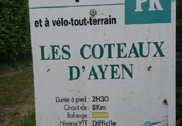
suivre fléchage jaune.