![](/images/other/stat-length.png)
![Tour Wandern Lançon-Provence - Lancon de Provence chapelle St Symphorien - Photo](https://media.geolcdn.com/t/1900/400/38f6fbf8-2d9f-4fce-b130-244396375811.jpg&format=pjpeg&maxdim=2)
Lancon de Provence chapelle St Symphorien
Manoune
Benutzer
![Länge](/images/other/stat-length.png)
Länge
18,7 km
![Maximale Höhe](https://static1.geolcdn.com/siteimages/upload/files/1508320355ic_sort_altitude_max_24dp.png)
Maximale Höhe
191 m
![Positive Höhendifferenz](https://static1.geolcdn.com/siteimages/upload/files/1508320355ic_sort_den_pos_24dp.png)
Positive Höhendifferenz
256 m
![Km-Effort](/images/other/stat-length.png)
Km-Effort
22 km
![Min. Höhe](https://static1.geolcdn.com/siteimages/upload/files/1508320355ic_sort_altitude_min_24dp.png)
Min. Höhe
83 m
![Negative Höhendifferenz](https://static1.geolcdn.com/siteimages/upload/files/1508320355ic_sort_den_neg_24dp.png)
Negative Höhendifferenz
257 m
![Boucle](https://static1.geolcdn.com/siteimages/upload/files/16400158638029165_repeat_loop_refresh_sync_direction_icon.png)
Boucle
Ja
Erstellungsdatum :
2021-11-07 08:00:55.236
Letzte Änderung :
2021-11-09 07:43:43.014
![Wandern](https://static1.geolcdn.com/sitytour/trail-icons/101.png)
6h01
Schwierigkeit : Medium
![Scannen Sie diesen QR-Code, um die Tour in der SityTrail-Anwendung zu öffnen](https://capi.geolives.com/qq0zvz2zws4bq2lad0pu/sitytour/trails/2995506/qr.png?size=200)
Kostenlosegpshiking-Anwendung
Über SityTrail
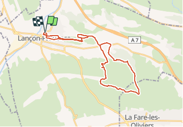
Tour Wandern von 18,7 km verfügbar auf Provence-Alpes-Côte d'Azur, Bouches-du-Rhône, Lançon-Provence. Diese Tour wird von Manoune vorgeschlagen.
Beschreibung
Parking sous le château. Visite du village. Coste Longue. Le Devenset. Bonsoy, GR de pays 2013, Stèle aux pompiers. Le Paty. Les Barriès. Chapelle St Symphorien et retour par la crête de la colline et parking.
Ort
Land:
France
Region :
Provence-Alpes-Côte d'Azur
Abteilung/Provinz :
Bouches-du-Rhône
Kommune :
Lançon-Provence
Standort:
Unknown
Gehen Sie:(Dec)
Gehen Sie:(UTM)
671669 ; 4828963 (31T) N.
Kommentare
Touren in der Umgebung
![Tour Wandern Lançon-Provence - muet - Photo](https://media.geolcdn.com/t/375/260/ext.jpg?maxdim=2&url=https%3A%2F%2Fservices.sitytrail.com%2FGeolivesWS%2FDownloadMedia.ashx%3FTrailID%3D1146327%26Media%3Dfix__20190430150458.jpg)
![Wandern Wandern](https://static1.geolcdn.com/sitytour/trail-icons/101.png)
muet
Wandern
Medium
(1)
Lançon-Provence,
Provence-Alpes-Côte d'Azur,
Bouches-du-Rhône,
France
![](/images/other/stat-length.png)
9,9 km | 11,9 km-effort
2h 18min
![](https://static1.geolcdn.com/siteimages/upload/files/16400158638029165_repeat_loop_refresh_sync_direction_icon.png)
Ja
![Wandern Wandern](https://static1.geolcdn.com/sitytour/trail-icons/101.png)
PF-Grans - Miramas Lac de Saint Sulpi - Grans
Wandern
Medium
Grans,
Provence-Alpes-Côte d'Azur,
Bouches-du-Rhône,
France
![](/images/other/stat-length.png)
20 km | 23 km-effort
5h 44min
![](https://static1.geolcdn.com/siteimages/upload/files/16400158638029165_repeat_loop_refresh_sync_direction_icon.png)
Ja
![Tour Wandern La Barben - La barben canal - Photo](https://media.geolcdn.com/t/375/260/ext.jpg?maxdim=2&url=https%3A%2F%2Fstatic1.geolcdn.com%2Fsiteimages%2Fupload%2Ffiles%2F1553511878bg_sport_marche.png)
![Wandern Wandern](https://static1.geolcdn.com/sitytour/trail-icons/101.png)
La barben canal
Wandern
Sehr leicht
(1)
La Barben,
Provence-Alpes-Côte d'Azur,
Bouches-du-Rhône,
France
![](/images/other/stat-length.png)
11,5 km | 12,7 km-effort
2h 51min
![](https://static1.geolcdn.com/siteimages/upload/files/16400158638029165_repeat_loop_refresh_sync_direction_icon.png)
Ja
![Wandern Wandern](https://static1.geolcdn.com/sitytour/trail-icons/101.png)
PF-Cornillon-Confoux - Le sentier des Bories
Wandern
Sehr leicht
Cornillon-Confoux,
Provence-Alpes-Côte d'Azur,
Bouches-du-Rhône,
France
![](/images/other/stat-length.png)
11,2 km | 12,8 km-effort
2h 50min
![](https://static1.geolcdn.com/siteimages/upload/files/16400158638029165_repeat_loop_refresh_sync_direction_icon.png)
Ja
![Wandern Wandern](https://static1.geolcdn.com/sitytour/trail-icons/101.png)
PF-Grans - Confoux
Wandern
Einfach
Grans,
Provence-Alpes-Côte d'Azur,
Bouches-du-Rhône,
France
![](/images/other/stat-length.png)
8,1 km | 8,8 km-effort
2h 0min
![](https://static1.geolcdn.com/siteimages/upload/files/16400158638029165_repeat_loop_refresh_sync_direction_icon.png)
Ja
![Tour Wandern Lançon-Provence - Autour de LFMY - Photo](https://media.geolcdn.com/t/375/260/a7368e75-f056-447e-9239-1dfb2794c3b2.jpeg&format=jpg&maxdim=2)
![Wandern Wandern](https://static1.geolcdn.com/sitytour/trail-icons/101.png)
Autour de LFMY
Wandern
Medium
Lançon-Provence,
Provence-Alpes-Côte d'Azur,
Bouches-du-Rhône,
France
![](/images/other/stat-length.png)
5,9 km | 6,5 km-effort
1h 37min
![](https://static1.geolcdn.com/siteimages/upload/files/16400158638029165_repeat_loop_refresh_sync_direction_icon.png)
Ja
![Tour Wandern La Barben - La Barben- Vallon de l'Aphoticaire - Photo](https://media.geolcdn.com/t/375/260/ext.jpg?maxdim=2&url=https%3A%2F%2Fstatic1.geolcdn.com%2Fsiteimages%2Fupload%2Ffiles%2F1553511878bg_sport_marche.png)
![Wandern Wandern](https://static1.geolcdn.com/sitytour/trail-icons/101.png)
La Barben- Vallon de l'Aphoticaire
Wandern
Medium
(1)
La Barben,
Provence-Alpes-Côte d'Azur,
Bouches-du-Rhône,
France
![](/images/other/stat-length.png)
9,6 km | 10,9 km-effort
2h 27min
![](https://static1.geolcdn.com/siteimages/upload/files/16400158638029165_repeat_loop_refresh_sync_direction_icon.png)
Ja
![Tour Wandern Lançon-Provence - Lançon-Coste longue/St Symphorien - Photo](https://media.geolcdn.com/t/375/260/ext.jpg?maxdim=2&url=https%3A%2F%2Fstatic1.geolcdn.com%2Fsiteimages%2Fupload%2Ffiles%2F1553511878bg_sport_marche.png)
![Wandern Wandern](https://static1.geolcdn.com/sitytour/trail-icons/101.png)
Lançon-Coste longue/St Symphorien
Wandern
Medium
(1)
Lançon-Provence,
Provence-Alpes-Côte d'Azur,
Bouches-du-Rhône,
France
![](/images/other/stat-length.png)
8,2 km | 9,7 km-effort
2h 11min
![](https://static1.geolcdn.com/siteimages/upload/files/16400158638029165_repeat_loop_refresh_sync_direction_icon.png)
Ja
![Tour Wandern Cornillon-Confoux - Confoux-Mur des abeilles - Photo](https://media.geolcdn.com/t/375/260/ext.jpg?maxdim=2&url=https%3A%2F%2Fstatic1.geolcdn.com%2Fsiteimages%2Fupload%2Ffiles%2F1553511878bg_sport_marche.png)
![Wandern Wandern](https://static1.geolcdn.com/sitytour/trail-icons/101.png)
Confoux-Mur des abeilles
Wandern
Medium
(2)
Cornillon-Confoux,
Provence-Alpes-Côte d'Azur,
Bouches-du-Rhône,
France
![](/images/other/stat-length.png)
7 km | 8,1 km-effort
1h 50min
![](https://static1.geolcdn.com/siteimages/upload/files/16400158638029165_repeat_loop_refresh_sync_direction_icon.png)
Ja